
Execution Rocks Light is a lighthouse in the middle of Long Island Sound on the border between New Rochelle and Sands Point, New York. It stands 55 feet (17 m) tall, with a white light flashing every 10 seconds. The granite tower is painted white with a brown band around the middle. It has an attached stone keeper's house which has not been inhabited since the light was automated in 1979.
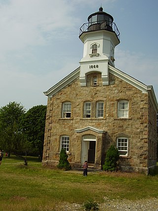
The Sands Point Lighthouse is located in the Incorporated Village of Sands Point in the Town of North Hempstead, in Nassau County, on the North Shore of Long Island, in New York, United States. The fourth lighthouse to be established on Long Island, this 1809 stone tower was built by an American Revolutionary War veteran who stayed on as its first keeper for many years. The Lighthouse is sometimes referred to the Mitchell Lighthouse, after Samuel L. Mitchell, the man who fought for it to be constructed.
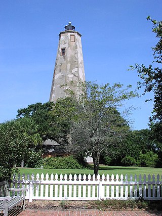
Bald Head Lighthouse, known as Old Baldy, is the oldest lighthouse still standing in North Carolina. It is the second of three lighthouses that have been built on Bald Head Island since the 18th century to help guide ships past the dangerous shoals at the mouth of the Cape Fear river.

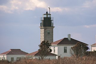
Block Island Southeast Light is a lighthouse located on Mohegan Bluffs at the southeastern corner of Block Island, Rhode Island. It was designated a U.S. National Historic Landmark in 1997 as one of the most architecturally sophisticated lighthouses built in the United States in the 19th century.

Barnegat Lighthouse or Barnegat Light, is a historic lighthouse located in Barnegat Lighthouse State Park on the northern tip of Long Beach Island, in the borough of Barnegat Light, Ocean County, New Jersey on the south side of Barnegat Inlet.
Sheffield Island Light is a historic lighthouse located at the southern end of the Norwalk Islands in Norwalk, Connecticut. It marks the west side of the mouth of the Norwalk River on northern Long Island Sound.
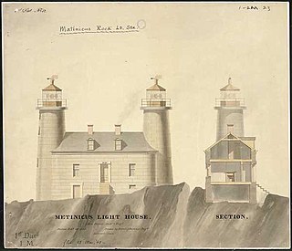
Matinicus Rock Light is a lighthouse on Matinicus Rock, a windswept rock 25 miles (40 km) off the coast of Maine. It is one of eleven seacoast lights off the coast of Maine. First established in 1827, the present surviving structures date to 1857. The lighthouse was added to the National Register of Historic Places as Matinicus Rock Light Station on March 14, 1988.

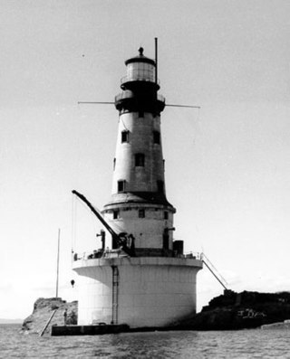
Because it was positioned near the busy shipping lanes of the mid-19th century, a lighthouse was built on Granite Island in 1868 by the U.S. Lighthouse Board and commissioned in 1869.

Great Captain Island Lighthouse is a lighthouse on Great Captain Island in the western Long Island Sound off the coast of Greenwich, Connecticut, United States. Built in 1829, the first lighthouse, made of stone, was of such poor construction that the walls were severely cracked a decade later. In 1868, a new granite dwelling with attached lantern was completed. The lighthouse is of the same design as lighthouses at Sheffield Island in Norwalk; Morgan Point in Noank; Old Field Point Light and Plum Island in New York; and Block Island North in Rhode Island. In 1890, a fog whistle was added, in 1905 a siren was installed. The lighthouse was deactivated in 1970 when a skeletal tower replaced it. The Town of Greenwich acquired the property in 1973 and had full-time caretakers on the site until the lighthouse became too dilapidated in 2003. A successful restoration effort was completed in 2009 and a non-navigational light was activated in 2012. In 2010, a memorial plaque was installed to "honor the 23 people who lived in Greenwich, or had a connection to the town", who died in the September 11, 2001 attacks. In 1991, the Great Captain Island Light was added to the National Register of Historic Places.

Black Rock Harbor Light, also known as Fayerweather Island Light, is a lighthouse in Bridgeport, Connecticut, United States which stands on the south end of Fayerweather Island and marks the entrance to Black Rock Harbor. The first lighthouse at the site, built by Abisha Woodward under contract with the United States government, was a wooden tower that was lit and made operational by 1808. A storm destroyed the tower in 1821 and the current, stone lighthouse was erected in its place in 1823. The Black Rock Harbor Light was an active navigational aid until 1933 when it was replaced by two automatic lights offshore. The beacon was subsequently given to the City of Bridgeport in 1934. Two significant efforts during the 1980s and 1990s served to restore the aging tower and the light was relit as a non-navigational aid in 2000. Black Rock Lighthouse is listed as a contributing property for Bridgeport's Seaside Park historic district.
Beavertail Lighthouse was built in 1856 and is the premier lighthouse in Rhode Island, marking the entrance to Narragansett Bay. The 64-foot (20 m) lighthouse lies on the southernmost point of Conanicut Island in the town of Jamestown, Rhode Island in Beavertail State Park, on a site where beacons have stood since the early 18th century. The light provides navigation for boats and ships entering Narragansett Bay in the East Passage between Conanicut Island and Newport, Rhode Island on Aquidneck Island. Other lighthouses are visible from Beavertail Lighthouse, such as Castle Hill Lighthouse, Point Judith Light, and Rose Island Light.

North Dumpling Light is a lighthouse on North Dumpling Island in Long Island Sound off Fishers Island, New York. It was constructed in 1849, rebuilt in 1871, and deactivated in 1959, with the aid to navigation being moved to an automated metal tower placed nearby. The lighthouse itself and the grounds around it were sold to a private party. Around 1977, a new owner convinced the U. S. Coast Guard to return the light to the lighthouse and remove the skeleton tower.

The Copper Harbor Light is a lighthouse located in the harbor of Copper Harbor, Michigan USA on the Keweenaw Peninsula of Upper Michigan inside Fort Wilkins Historic State Park. It is a Michigan State Historic Site and listed on the National Register of Historic Places.
The Rock of Ages Light is a U.S. Coast Guard lighthouse on a small rock outcropping approximately 2.25 miles (3.62 km) west of Washington Island and 3.5 miles (5.6 km) west of Isle Royale, in Eagle Harbor Township, Keweenaw County, Michigan. It is an active aid to navigation.

Plum Island Light is located on the western end of Plum Island, which lies in the Long Island Sound, east of Orient Point at the end of the North Fork of Long Island, New York. An historic granite lighthouse originally built in 1869 sits at the site, but no longer serves as an active aid to navigation. It was listed on the National Register of Historic Places in 2011.

Point Clark Lighthouse is located on in a beach community, Point Clark, Ontario, near a point that protrudes into Lake Huron. Built between 1855 and 1859 under the instructions of the Board of Works, Canada West, it is one of the few on the Great Lakes to be made primarily from stone. It is one of the Imperial Towers, a group of six nearly identical towers built by contractor John Brown for the "Province of Canada" on Lake Huron and Georgian Bay, all completed by 1859. The location for the Point Clark lighthouse was selected to warn sailors of the shoals (sandbars) 2 miles (3.2 km) off the Lake Huron coast. It is still functioning as an automated light. A restoration that eventually exceeded $2.3 million started in 2011 and the facility reopened for tourism in June 2015.

Bird Island Light is a historic lighthouse at the entrance to Sippican Harbor in Marion, Massachusetts. Built in 1819, its tower is a well-preserved example of an early 19th-century masonry lighthouse. The tower and the island on which it stands were added to the National Register of Historic Places as Bird Island Light on September 28, 1987.

Marshall Point Light Station is a lighthouse at the entrance of Port Clyde Harbor in Port Clyde, Maine. The light station was established in 1832.

Seguin Light is a lighthouse on Seguin Island, in the Gulf of Maine south of the mouth of the Kennebec River, Maine. Established in 1795, it is the second-oldest of Maine's coastal lighthouses, and the only lighthouse in the state housing a first-order Fresnel lens. With its light at 180 feet (55 m) above mean sea-level, the present tower, built in 1857, is its highest of the state's lighthouses. Automated in 1985, the buildings of the light station are now operated as a museum property by a non-profit organization, and are seasonally open to the public via scheduled ferry from Popham Beach in Phippsburg. The light was listed on the National Register of Historic Places as Seguin Island Light Station in 1977.

The Ontonagon Light is a lighthouse located off M-64 near Ontonagon, Michigan. It was listed on the National Register of Historic Places in 1975 and designated a Michigan State Historic Site in 1973.


