Hot Springs, North Carolina

Last updated

Hot Springs, North Carolina
Town of Hot Springs
Hot Springs, NC.jpg
Hot Springs and the French Broad River, as seen from the Appalachian Trail
NCMap-doton-HotSprings.PNG
Location of Hot Springs, North Carolina
Coordinates: 35°53′36″N82°49′49″W / 35.89333°N 82.83028°W / 35.89333; -82.83028
Country United States
State North Carolina
County Madison
Discovered1778 [1]
Founded1800 [1]
Incorporated1889 [1]
Named for Thermal springs in area [1]
Area
[2]
  Total3.13 sq mi (8.12 km2)
  Land2.87 sq mi (7.43 km2)
  Water0.27 sq mi (0.69 km2)
Elevation
[3]
1,378 ft (420 m)
Population
 (2020)
  Total520
  Density181.37/sq mi (70.03/km2)
Time zone UTC-5 (Eastern (EST))
  Summer (DST) UTC-4 (EDT)
ZIP code
28743
Area code 828
FIPS code 37-32840 [4]
GNIS feature ID2405868 [3]
Website hotspringsnc.org

Hot Springs is a town in Madison County, North Carolina, United States. The population was 520 at the 2020 census. It is part of the Asheville metropolitan statistical area. It is situated on the Appalachian Trail and French Broad River near the North Carolina-Tennessee border. Hot Springs is best known for its hiking trails, natural springs, and mountain town atmosphere.

Contents

History

Hot Springs is located at the confluence of the French Broad River and Spring Creek. A natural thermal spring is located there, [5] the only hot spring known in North Carolina and in much of the southeastern United States. Thus, this area has long been a destination for those looking for therapeutic relief from their ailments. Native Americans were the first to discover and use the 108°F (42°C) [6] mineral waters, and European immigrants settled the area over 200 years ago. It is reported that people were visiting the springs by 1778 for the waters' reported healing properties.

It was believed Jasper Dagy was the first owner of Warm Springs, as it was then called, and he sold it to William Neilson in 1791. Neilson built an inn, and Philip Hoodenpile built an estate and a ferry across the French Broad, as well as the toll road Jewel Hill Road. [7] In 1828, a major road was constructed through the town, the Buncombe Turnpike, making the area more accessible.

By 1831, James Patton of Asheville bought the springs and had erected 350 room Warm Springs Hotel with its 13 tall columns representing the Thirteen Colonies in 1837. The dining room of this large hotel could seat 600 people. The railroad reached the village in 1882. The hotel burned in 1884 after 46 years of operation. Another hotel, called the Mountain Park, was built in 1886.

A higher temperature spring was found, prompting the changing of the town's name from Warm Springs to Hot Springs in 1886. Sixteen marble pools were surrounded by landscaped lawns with croquet and tennis courts, and it was known as one of the most lavish resorts in the Southeast. By May 1917, the hotel and grounds were leased to the US Government to be used as an internment camp. Many German and Austro-Hungarian internees, noncombatant aliens, made local friends and stayed in the region after World War I. That hotel burned in 1920, and two more were built—neither as large and opulent, and both later burned as well.

Geography

According to the United States Census Bureau, the town has a total area of 3.5 square miles (9.1 km2), of which 3.2 square miles (8.3 km2) is land and 0.3 square miles (0.78 km2) (8.96%) is water.

Climate

Climate data for Hot Springs, North Carolina, 19912020 normals, extremes 1984present
MonthJanFebMarAprMayJunJulAugSepOctNovDecYear
Record high °F (°C)80
(27)
85
(29)
88
(31)
92
(33)
96
(36)
102
(39)
104
(40)
100
(38)
98
(37)
95
(35)
86
(30)
79
(26)
104
(40)
Mean maximum °F (°C)68.1
(20.1)
72.1
(22.3)
78.9
(26.1)
86.0
(30.0)
88.3
(31.3)
92.4
(33.6)
93.7
(34.3)
92.9
(33.8)
91.5
(33.1)
84.9
(29.4)
77.2
(25.1)
70.2
(21.2)
95.2
(35.1)
Mean daily maximum °F (°C)48.3
(9.1)
52.3
(11.3)
60.4
(15.8)
70.5
(21.4)
77.9
(25.5)
84.3
(29.1)
87.2
(30.7)
86.4
(30.2)
81.9
(27.7)
71.6
(22.0)
60.4
(15.8)
51.5
(10.8)
69.4
(20.8)
Daily mean °F (°C)38.4
(3.6)
41.6
(5.3)
48.6
(9.2)
57.4
(14.1)
65.7
(18.7)
72.9
(22.7)
76.3
(24.6)
75.5
(24.2)
70.3
(21.3)
59.3
(15.2)
48.4
(9.1)
41.5
(5.3)
58.0
(14.4)
Mean daily minimum °F (°C)28.5
(−1.9)
30.8
(−0.7)
36.7
(2.6)
44.2
(6.8)
53.5
(11.9)
61.5
(16.4)
65.4
(18.6)
64.5
(18.1)
58.8
(14.9)
46.9
(8.3)
36.3
(2.4)
31.6
(−0.2)
46.6
(8.1)
Mean minimum °F (°C)10.4
(−12.0)
15.9
(−8.9)
21.3
(−5.9)
28.9
(−1.7)
38.6
(3.7)
50.6
(10.3)
58.0
(14.4)
56.9
(13.8)
45.8
(7.7)
30.9
(−0.6)
21.4
(−5.9)
16.6
(−8.6)
8.1
(−13.3)
Record low °F (°C)−1
(−18)
−2
(−19)
11
(−12)
20
(−7)
32
(0)
35
(2)
48
(9)
45
(7)
37
(3)
25
(−4)
13
(−11)
2
(−17)
−2
(−19)
Average precipitation inches (mm)3.66
(93)
3.34
(85)
3.99
(101)
3.83
(97)
4.50
(114)
5.22
(133)
4.67
(119)
4.93
(125)
3.35
(85)
2.40
(61)
2.86
(73)
3.91
(99)
46.66
(1,185)
Average snowfall inches (cm)1.6
(4.1)
2.6
(6.6)
0.5
(1.3)
0.0
(0.0)
0.0
(0.0)
0.0
(0.0)
0.0
(0.0)
0.0
(0.0)
0.0
(0.0)
0.0
(0.0)
0.2
(0.51)
1.2
(3.0)
6.1
(15.51)
Average precipitation days (≥ 0.01 in)12.112.212.611.112.312.912.610.98.88.09.111.6134.2
Average snowy days (≥ 0.1 in)2.11.50.70.00.00.00.00.00.00.00.21.05.5
Source: NOAA [8] [9]

Demographics

Historical population
CensusPop.Note
1890 695
1900 445−36.0%
1910 443−0.4%
1920 49511.7%
1930 63728.7%
1940 77321.4%
1950 721−6.7%
1960 7230.3%
1970 653−9.7%
1980 6783.8%
1990 478−29.5%
2000 64534.9%
2010 560−13.2%
2020 520−7.1%
U.S. Decennial Census [10]

2020 census

Hot Springs racial composition [11]
RaceNumberPercentage
White (non-Hispanic)46088.46%
Native American 10.19%
Asian 20.38%
Other/Mixed 489.23%
Hispanic or Latino 91.73%

As of the 2020 United States census, there were 520 people, 223 households, and 143 families residing in the town.

Economy

Today, the hot mineral springs are privately owned by a spa and private lodging rental businesses. [12] Water is piped to outdoor tubs beside the river and Spring Creek. The town is a tourist destination, with the springs as well as abundant outdoor recreation. The Appalachian Trail runs along downtown's Bridge Street and climbs the mountains on either side of the river. Rafting and kayaking is popular on the French Broad River. There are numerous other hiking, mountain biking, backpacking, and sightseeing opportunities in the nearby Pisgah National Forest.

Hot Springs Historic District

Hot Springs Historic District was listed on the National Register of Historic Places in 2009. [13] Also listed on the National Register of Historic Places are Dorland Memorial Presbyterian Church, the Henry Ottinger House, and Sunnybank.

Related Research Articles

<span class="mw-page-title-main">Banner Elk, North Carolina</span> Town in North Carolina, United States

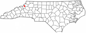
Banner Elk is a town in Avery County, North Carolina, United States. The population was 1,028 at the 2010 census. Banner Elk is home to Lees–McRae College.

<span class="mw-page-title-main">Asheville, North Carolina</span> City in North Carolina, United States

Asheville is a city in and the county seat of Buncombe County, North Carolina, United States. Located at the confluence of the French Broad and Swannanoa rivers, it is the most populous city in Western North Carolina, and the state's 11th-most-populous city. According to the 2020 census, the city's population was 94,589, up from 83,393 in the 2010 census. It is the principal city in the three-county Asheville metropolitan area, which had an estimated population of 417,202 in 2023.

<span class="mw-page-title-main">Black Mountain, North Carolina</span> Town in North Carolina

Black Mountain is a town in Buncombe County, North Carolina, United States. The population was 8,426 at the 2020 United States census. It is part of the Asheville Metropolitan Statistical Area. The town is named for the old train stop at the Black Mountain Depot and is located at the southern end of the Black Mountain range of the Blue Ridge Mountains in the Southern Appalachians.

<span class="mw-page-title-main">Lake Junaluska, North Carolina</span> Census-designated place in North Carolina, United States

Lake Junaluska is a census-designated place (CDP) in Haywood County, North Carolina, United States, and an artificial lake in the Blue Ridge Mountains. It is part of the Asheville Metropolitan Statistical Area.

<span class="mw-page-title-main">Waynesville, North Carolina</span> Town in North Carolina, United States

Waynesville is the county seat of Haywood County, North Carolina. It is the largest town in North Carolina west of Asheville. Waynesville is located about 30 miles (50 km) southwest of Asheville between the Great Smoky and Blue Ridge Mountains.

<span class="mw-page-title-main">Hendersonville, North Carolina</span> City in North Carolina, United States

Hendersonville is a city in and the county seat of Henderson County, North Carolina, United States, located 22 miles (35 km) south of Asheville. Like the county, the city is named for 19th-century North Carolina Supreme Court Chief Justice Leonard Henderson.

<span class="mw-page-title-main">Franklin, North Carolina</span> Town in North Carolina, United States

Franklin is a town in and the county seat of Macon County, North Carolina, United States. It is situated within the Nantahala National Forest. The population was reported to be 4,175 in the 2020 census, an increase from the total of 3,845 tabulated in 2010.

<span class="mw-page-title-main">Spruce Pine, North Carolina</span> Town in North Carolina, United States

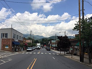
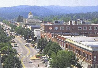
Spruce Pine is the largest town in Mitchell County, North Carolina, United States. The population was 2,175 at the 2010 census.

<span class="mw-page-title-main">Tryon, North Carolina</span> Town in Polk County, North Carolina, United States

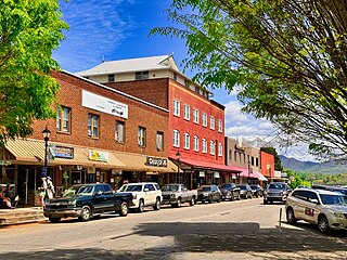
Tryon is a town in Polk County, on the southwestern border of North Carolina, United States. As of the 2020 census, the city population was 1,562. Located in the escarpment of the Blue Ridge Mountains, today the area is affluent and a center for outdoor pursuits, equestrian activity, and fine arts.

<span class="mw-page-title-main">Newport, Tennessee</span> City and county seat of Cocke County, Tennessee, United States

Newport is a city in and the county seat of Cocke County, Tennessee, United States. The population was 6,945 at the 2010 census, down from 7,242 at the 2000 census. The estimated population in 2018 was 6,801. Newport is located along the Pigeon River.

<span class="mw-page-title-main">Clintwood, Virginia</span> Town in Virginia, United States

Clintwood is a town in Dickenson County, Virginia, United States. The population was 1,377 at the 2020 census. It is the county seat of Dickenson County.

<span class="mw-page-title-main">Stuart, Virginia</span> Town in Virginia, United States

Stuart is a town in Patrick County, Virginia, United States, where it is the county seat. The population was 1,408 at the 2010 census. The town of Stuart was named after Confederate Gen. J.E.B. Stuart, of nearby Ararat, Virginia.

<span class="mw-page-title-main">Abingdon, Virginia</span> Town in Virginia, United States

Abingdon is a town in Washington County, Virginia, United States, 133 miles (214 km) southwest of Roanoke. The population was 8,376 at the 2020 census. It is the county seat of Washington County. The town encompasses several historically significant sites and features a fine arts and crafts scene centered on the galleries and museums along Main Street.

<span class="mw-page-title-main">Highlands, North Carolina</span> Town in North Carolina, United States

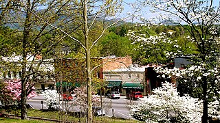
Highlands is an incorporated town in Macon County in the U.S. state of North Carolina. Located on a plateau in the southern Appalachian Mountains, within the Nantahala National Forest, it lies mostly in southeastern Macon County and slightly in southwestern Jackson County, in the Highlands and Cashiers Townships, respectively. The permanent population was 1,014 at the 2020 census.

<span class="mw-page-title-main">French Broad River</span> River in North Carolina and Tennessee, United States

The French Broad River is a river in the U.S. states of North Carolina and Tennessee. It flows 218 miles (351 km) from near the town of Rosman in Transylvania County, North Carolina, into Tennessee, where its confluence with the Holston River at Knoxville forms the beginning of the Tennessee River. The river flows through the counties of Transylvania, Buncombe, Henderson, and Madison in North Carolina, and Cocke, Jefferson, Sevier, and Knox in Tennessee. It drains large portions of the Pisgah National Forest and the Cherokee National Forest.

<span class="mw-page-title-main">Cherokee, North Carolina</span> Census-designated place in North Carolina, United States

Cherokee is a census-designated place (CDP) in Swain and Jackson counties in Western North Carolina, United States, within the Qualla Boundary land trust. Cherokee is located in the Oconaluftee River Valley around the intersection of U.S. Routes 19 and 441. As of the 2020 census, the CDP had a population of 2,195. It is the capital of the federally recognized Eastern Band of Cherokee Indians, one of three recognized Cherokee tribes and the only one in North Carolina.

<span class="mw-page-title-main">Hot Springs, Virginia</span> Census-designated place in Virginia, United States

Hot Springs is a census-designated place (CDP) in Bath County, Virginia, United States. The population as of the 2010 Census was 738. It is located about 5 miles southwest of Warm Springs on U.S. Route 220.

<span class="mw-page-title-main">Pisgah National Forest</span> National forest in North Carolina

Pisgah National Forest is a National Forest in the Appalachian Mountains of western North Carolina. It is administered by the United States Forest Service, part of the United States Department of Agriculture. The Pisgah National Forest is completely contained within the state of North Carolina. The forest is managed together with the other three North Carolina National Forests from common headquarters in Asheville, North Carolina. There are local ranger district offices located in Pisgah Forest, Mars Hill, and Nebo.

<span class="mw-page-title-main">Western North Carolina</span> Geographic region of the U.S. state of North Carolina

Western North Carolina is the region of North Carolina which includes the Appalachian Mountains; it is often known geographically as the state's Mountain Region. It contains the highest mountains in the Eastern United States, with 125 peaks rising to over 5,000 feet in elevation. Mount Mitchell at 6,684 feet, is the highest peak of the Appalachian Mountains and mainland eastern North America. The population of the 23 most commonly associated counties for the region, as measured by the 2020 U.S. Census, is 1,149,405. The region accounts for approximately 11% of North Carolina's total population.

<span class="mw-page-title-main">U.S. Route 25 in North Carolina</span> Segment of American highway

U.S. Highway 25 (US 25) is a north–south United States Numbered Highway that runs for 75.4 miles (121.3 km) from the South Carolina state line, near Tuxedo, to the Tennessee state line, near Hot Springs. It is part of the longer US 25, which runs from Brunswick, Georgia, to Covington, Ohio. It is a major north–south route through Western North Carolina.

References

  1. 1 2 3 4 "North Carolina Gazetteer" . Retrieved December 19, 2022.
  2. "ArcGIS REST Services Directory". United States Census Bureau. Retrieved September 20, 2022.
  3. 1 2 U.S. Geological Survey Geographic Names Information System: Hot Springs, North Carolina
  4. "U.S. Census website". United States Census Bureau . Retrieved January 31, 2008.
  5. NOAA (1980). Thermal Springs List for the United States. Boulder, CO: National Oceanic and Atmospheric Administration.
  6. NOAA. "List of hot springs in the United States". National Oceanic and Aeronautical Association. Retrieved February 21, 2020.
  7. Neufeld, Rob (August 18, 2019). "Visiting Our Past: Roads, orphans, speculation and missing ears occupied first settlers". Asheville Citizen-Times . Retrieved August 18, 2019.
  8. "NOWData - NOAA Online Weather Data". National Oceanic and Atmospheric Administration.
  9. "Summary of Monthly Normals 19912020". National Oceanic and Atmospheric Administration . Retrieved October 15, 2021.
  10. "Census of Population and Housing". Census.gov. Retrieved June 4, 2015.
  11. "Explore Census Data". data.census.gov. Retrieved December 19, 2021.
  12. "Hot Mineral Springs - Hot Springs NC Travel and Visitor Information". Hot Springs Tourism Association. July 23, 2017. Retrieved June 13, 2019.
  13. "National Register Information System". National Register of Historic Places . National Park Service. July 9, 2010.