Howard City, Michigan

Last updated

Howard City, Michigan
Montcalm County Michigan Incorporated and Unincorporated areas Howard City Highlighted.svg
Location in Montcalm County and the state of Michigan
Coordinates: 43°23′41″N85°28′06″W / 43.39472°N 85.46833°W / 43.39472; -85.46833
Country United States
State Michigan
County Montcalm
Townships Reynolds, Pierson
Founded1868
Incorporated1873 (village)
Area
[1]
  Total2.45 sq mi (6.34 km2)
  Land2.42 sq mi (6.25 km2)
  Water0.03 sq mi (0.09 km2)
Elevation
[2]
879 ft (268 m)
Population
 (2020) [3]
  Total1,835
  Density759.83/sq mi (293.41/km2)
Time zone UTC-5 (Eastern (EST))
  Summer (DST) UTC-4 (EDT)
ZIP code
49329
Area code 231
FIPS code 26-39500 [4]
GNIS feature ID2398547 [2]
Website www.howardcity.org

Howard City is a village in Montcalm County in the U.S. state of Michigan. The population was 1,835 at the 2020 census. [3] The village is within Reynolds Township.

Contents

History

Benjamin Ensley owned the land on which he, E. W. Muenscher, and Mr. Shaw began the settlement that Muenscher platted in 1868. It was named for William A. Howard, a Detroit railroad attorney. The Detroit, Grand Rapids and Western Railroad depot opened in 1869. A post office was established on January 12, 1870, with John B. Spencer as the first postmaster. It incorporated as a village in 1873. The post office name was shortened to "Howard" on February 2, 1895, but restored to Howard City on January 19, 1899. [5]

The village's Main Street was initially constructed on Ensley Street, which was named after early settler Benjamin Ensley. In 1883, however, many of the wooden buildings on Ensley Street burned down. Main Street was then shifted over to Edgerton Street, its present location. The Hudson Knife factory and the Skinner and Steenman sideboard factory were two of the earliest businesses. Later, Hudson Knife Co. went through changes and became the Joslin and eventually Olsen Knife Company, which had the somewhat famous jingle, "Fatty Fatty run for your life, here comes Skinny with an Olsen Knife."[ citation needed ] Howard City schools were combined with Sand Lake schools to the south in 1962, and renamed Tri County, because students from Kent, Montcalm, and Newaygo counties all attended. The school still runs under the same moniker.[ citation needed ]

Geography

Howard City is in northwestern Montcalm County, in the southeast corner of Reynolds Township. A small portion of the village extends south into Pierson Township. The U.S. 131 freeway passes 2 miles (3 km) west of the village, with access from Exit 118. U.S. 131 leads south-southwest 34 miles (55 km) to Grand Rapids and north 63 miles (101 km) to Cadillac. Greenville, the largest city in Montcalm County, is 25 miles (40 km) southeast of Howard City.

According to the U.S. Census Bureau, the village has a total area of 2.44 square miles (6.32 km2), of which 0.03 square miles (0.08 km2), or 1.39%, are water. [1] Tamarack Creek, a west-flowing tributary of the Little Muskegon River, passes through the north side of the village.

The Howard City post office, with ZIP code 49329, also serves much of southern Reynolds Township, as well as a large part of Winfield Township to the east, a small area of Maple Valley Township to the southeast, portions of Pierson Township to the south. It also serves parts of Croton Township to the west and Ensley Township to the southwest in Newaygo County. [6]

Demographics

Historical population
CensusPop.Note
1880 924
1890 1,13723.1%
1900 1,39823.0%
1910 1,046−25.2%
1920 913−12.7%
1930 872−4.5%
1940 839−3.8%
1950 791−5.7%
1960 1,00426.9%
1970 1,0605.6%
1980 1,1185.5%
1990 1,35120.8%
2000 1,58517.3%
2010 1,80814.1%
2020 1,8351.5%
U.S. Decennial Census [7]

2010 census

As of the census [8] of 2010, there were 1,808 people, 685 households, and 464 families residing in the village. The population density was 714.6 inhabitants per square mile (275.9/km2). There were 743 housing units at an average density of 293.7 per square mile (113.4/km2). The racial makeup of the village was 96.3% White, 0.6% African American, 0.6% Native American, 0.2% Asian, 0.8% from other races, and 1.5% from two or more races. Hispanic or Latino of any race were 2.4% of the population.

There were 685 households, of which 39.7% had children under the age of 18 living with them, 45.1% were married couples living together, 17.4% had a female householder with no husband present, 5.3% had a male householder with no wife present, and 32.3% were non-families. 26.4% of all households were made up of individuals, and 10.9% had someone living alone who was 65 years of age or older. The average household size was 2.63 and the average family size was 3.13.

The median age in the village was 33.6 years. 29.4% of residents were under the age of 18; 9.1% were between the ages of 18 and 24; 26.9% were from 25 to 44; 21.8% were from 45 to 64; and 12.9% were 65 years of age or older. The gender makeup of the village was 46.6% male and 53.4% female.

2000 census

As of the census [4] of 2000, there were 1,585 people, 576 households, and 410 families residing in the village. The population density was 631.5 inhabitants per square mile (243.8/km2). There were 626 housing units at an average density of 249.4 per square mile (96.3/km2). The racial makeup of the village was 95.90% White, 0.19% African American, 0.57% Native American, 0.13% Asian, 0.95% from other races, and 2.27% from two or more races. Hispanic or Latino of any race were 2.59% of the population.

There were 576 households, out of which 38.7% had children under the age of 18 living with them, 52.4% were married couples living together, 14.1% had a female householder with no husband present, and 28.8% were non-families. 25.2% of all households were made up of individuals, and 13.9% had someone living alone who was 65 years of age or older. The average household size was 2.75 and the average family size was 3.22.

In the village, the population was spread out, with 32.3% under the age of 18, 8.9% from 18 to 24, 27.9% from 25 to 44, 17.7% from 45 to 64, and 13.2% who were 65 years of age or older. The median age was 32 years. For every 100 females, there were 84.9 males. For every 100 females age 18 and over, there were 83.4 males.

The median income for a household in the village was $34,556, and the median income for a family was $41,250. Males had a median income of $32,241 versus $22,917 for females. The per capita income for the village was $14,076. About 5.7% of families and 10.4% of the population were below the poverty line, including 13.4% of those under age 18 and 13.1% of those age 65 or over.

Transportation

Schools

Tri County Area Schools is the main school district in Howard City. Schools include Tri County High School, Tri County Middle School, MacNaughten Elementary, Sand Lake Elementary and Edgerton Upper Elementary. The School mascot is the Viking. Sports include football, basketball, softball, baseball, wrestling, sideline cheer, competitive cheer, golf, track and field, cross country, bowling, poms and soccer. In 2009, the varsity softball team took a District title, but fell short at regionals to Petosky. Neighboring schools include Newaygo, Grant, Morley-Stanwood, Lakeview and Cedar Springs.

The district was a consolidation of the Sand Lake and Howard City school boards. It came into existence on April 3, 1962, the day members of those communities voted in favor of consolidating their schools. The consolidated schools began operation in fall 1962. Prior to the consolidation, Howard City High School served the community. Impetus for consolidation occurred when the State of Michigan adopted new standards for education which required school systems to spend additional funds. A former member of the school board of Sand Lake, Charles Northup, stated, "Howard City was almost in the same predicament as us. We figured we would have a good school system coming together." [10] Sand Lake was a community which sought consolidation due to the financial strain from meeting the new requirements. [10]

Related Research Articles

<span class="mw-page-title-main">Newaygo County, Michigan</span> County in Michigan, United States

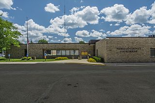
Newaygo County is a county in the U.S. state of Michigan. As of the 2020 United States Census, the population was 49,978. The county seat is White Cloud. The county was created in 1840, and was organized in 1851. It was either named for an Ojibwe leader who signed the Treaty of Saginaw in 1819 or for an Algonquian word meaning "much water".

<span class="mw-page-title-main">Montcalm County, Michigan</span> County in Michigan, United States

Montcalm County is a county in the U.S. state of Michigan. As of the 2020 Census, the population was 66,614. The county is geographically located in the West Michigan region of the Lower Peninsula. The county seat is Stanton, and the largest city is Greenville. The county is named for General Marquis Louis-Joseph de Montcalm, military commander of French troops during the French and Indian War. The county was set off in 1831 and organized in 1850.

<span class="mw-page-title-main">Mecosta County, Michigan</span> County in Michigan, United States

Mecosta County is a county located in the U.S. state of Michigan. As of the 2020 Census, the population was 39,714. The county seat is Big Rapids.

<span class="mw-page-title-main">Ionia County, Michigan</span> County in Michigan, United States

Ionia County is a county located in the U.S. state of Michigan. As of the 2020 census, the population was 66,804. The county seat is Ionia. The Ionia County Courthouse was designed by Claire Allen, a prominent southern Michigan architect.

<span class="mw-page-title-main">Sand Lake, Michigan</span> Village in Michigan, United States

Sand Lake is a village in Kent County in the U.S. state of Michigan. The population was 522 at the 2020 census.

Big Rapids Township is a charter township of Mecosta County in the U.S. state of Michigan. As of the 2020 census, the township population was 3,917.

Green Charter Township is a charter township of Mecosta County in the U.S. state of Michigan. As of the 2020 census, the township population was 3,219. The township was organized in 1858, before Mecosta County was detached from Newaygo County.

<span class="mw-page-title-main">Carson City, Michigan</span> City in Michigan, United States

Carson City is a city in Montcalm County of the U.S. state of Michigan. The population was 1,120 at the 2020 census.

<span class="mw-page-title-main">Greenville, Michigan</span> City in Michigan, United States

Greenville is a city in the Lower Peninsula of the U.S. state of Michigan. With a population 8,816 at the 2020 census, it is the largest city in Montcalm County. The city is the location of the establishment of the Meijer chain of stores.

<span class="mw-page-title-main">Lakeview, Michigan</span> Village in Michigan, United States

Lakeview is a village in Cato Township in Montcalm County of the U.S. state of Michigan. The population was 1,024 at the 2020 census.

Montcalm Township is a civil township of Montcalm County in the U.S. state of Michigan. The population was 3,394 at the 2020 census, up from 3,350 in 2010.

<span class="mw-page-title-main">Pierson, Michigan</span> Village in Michigan, United States

Pierson is a village in Montcalm County of the U.S. state of Michigan. The population was 229 at the 2020 census, up from 172 in 2010. The village is within Pierson Township.

Pierson Township is a civil township of Montcalm County in the U.S. state of Michigan. The population was 3,363 at the 2020 census. The village of Pierson is located within the township.

Reynolds Township is a civil township of Montcalm County in the U.S. state of Michigan. The population was 5,431 at the 2020 census.

<span class="mw-page-title-main">Stanton, Michigan</span> City in Michigan, United States

Stanton is a city in the U.S. state of Michigan. The population was 1,348 at the 2020 census. It is the county seat of Montcalm County.

Ensley Township is a civil township of Newaygo County in the U.S. state of Michigan. The population was 2,603 at the 2020 census.

<span class="mw-page-title-main">Solon Township, Kent County, Michigan</span> Civil township in Michigan, United States

Solon Township is a civil township of Kent County in the U.S. state of Michigan. The population was 6,496 at the 2020 census, a notable increase from 5,974 at the 2010 census.

Aetna Township is a civil township of Mecosta County in the U.S. state of Michigan. As of the 2020 census, the township population was 2,241.

Evergreen Township is a civil township of Montcalm County in the U.S. state of Michigan. The population was 2,941 at the 2020 census.

Tri County Area Schools is a school district headquartered in Sand Lake, Michigan. It serves sections of Kent, Montcalm, and Newaygo counties. It serves Sand Lake, Howard City, and Pierson as well as Pierson Township and Reynolds Township.

References

  1. 1 2 "2023 U.S. Gazetteer Files: Michigan". United States Census Bureau. Retrieved November 15, 2023.
  2. 1 2 U.S. Geological Survey Geographic Names Information System: Howard City, Michigan
  3. 1 2 "P1. Race – Howard City village, Michigan: 2020 DEC Redistricting Data (PL 94-171)". U.S. Census Bureau. Retrieved November 15, 2023.
  4. 1 2 "U.S. Census website". United States Census Bureau . Retrieved January 31, 2008.
  5. Romig, Walter (1986) [1973]. Michigan Place Names. Detroit, Michigan: Wayne State University Press. ISBN   0-8143-1838-X.
  6. ZCTA Reference Map for 49329 Archived February 10, 2020, at archive.today , U.S. Census Bureau, 2000 census
  7. "Census of Population and Housing". Census.gov. Retrieved June 4, 2015.
  8. "U.S. Census website". United States Census Bureau . Retrieved November 25, 2012.
  9. "GRAND RAPIDS-CADILLAC-TRAVERSE CITY-PETOSKEY" (PDF). Indian Trails. January 15, 2013. Retrieved March 9, 2013.[ permanent dead link ]
  10. 1 2 Ransom, Kay. "Tri County Area Schools: Over 50 Years in the Making ." Tri County Area Schools. Retrieved on October 21, 2017.