
Tuscaloosa County is a county in the northwest-central portion of the U.S. state of Alabama and is the center of commerce, education, industry, health care, and entertainment for the region.

Northport is a city in Tuscaloosa County in the west central part of the State of Alabama. Located on the Black Warrior River across from downtown Tuscaloosa, it is currently the 17th largest city in Alabama with an population of 31,125 in the 2020 US Census. It incorporated in 1871. It is part of the Tuscaloosa Metropolitan Statistical Area.

Tuscaloosa is a city in and the seat of Tuscaloosa County in west-central Alabama, United States, on the Black Warrior River where the Gulf Coastal and Piedmont plains meet. Alabama's fifth-most populous city, it had an estimated population of 110,602 in 2023. It was known as Tuskaloosa until the early 20th century. It is also known as "the Druid City" because of the numerous water oaks planted in its downtown streets since the 1840s.
U.S. Route 82 is an east–west United States highway in the Southern United States. Created on July 1, 1931 across central Mississippi and southern Arkansas, US 82 eventually became a 1,625-mile-long (2,615 km) route extending from the White Sands of New Mexico to Georgia's Atlantic coast.
The Black Warrior River is a waterway in west-central Alabama in the southeastern United States. The river rises in the extreme southern edges of the Appalachian Highlands and flows 178 miles (286 km) to the Tombigbee River, of which the Black Warrior is the primary tributary. The river is named after the Mississippian paramount chief Tuskaloosa, whose name was Muskogean for 'Black Warrior'. The Black Warrior is impounded along nearly its entire course by a series of locks and dams to form a chain of reservoirs that not only provide a path for an inland waterway, but also yield hydroelectric power, drinking water, and industrial water.

U.S. Route 43 (US 43) is a 410-mile-long (660 km) north–south United States Highway in the Southern states of Alabama and Tennessee. It travels from Prichard, Alabama, to Columbia, Tennessee. The highway's southern terminus is in Prichard, at an intersection with US 90, and its northern terminus is in Columbia at an intersection with US 31/US 412/US 412 Bus.

A trestle bridge is a bridge composed of a number of short spans supported by closely spaced frames. A trestle is a rigid frame used as a support, historically a tripod used to support a stool or a pair of isosceles triangles joined at their apices by a plank or beam such as the support structure for a trestle table. Each supporting frame is a bent. A trestle differs from a viaduct in that viaducts have towers that support much longer spans and typically have a higher elevation.
The Birmingham District is a geological area in the vicinity of Birmingham, Alabama, where the raw materials for making steel, limestone, iron ore, and coal are found together in abundance. The district includes Red Mountain, Jones Valley, and the Warrior and Cahaba coal fields in Central Alabama.
Robert Jemison Jr. was an American politician, entrepreneur and slave owner who served as a Confederate States Senator from Alabama from 1863 to 1865. He also served in the two houses of the Alabama Legislature from 1837 until 1863.

Area codes 205 and 659 are telephone area codes in the North American Numbering Plan (NANP) for the western and central parts of the U.S. State of Alabama, including the cities of Birmingham and Tuscaloosa.
Wilson's Raid was a cavalry operation through Alabama and Georgia in March–April 1865, late in the American Civil War. U.S. Brig. Gen. James H. Wilson led his U.S. Cavalry Corps to destroy Confederate manufacturing facilities and was opposed unsuccessfully by a much smaller force under Confederate Lt. Gen. Nathan Bedford Forrest.

The D&RG Narrow Gauge Trestle, also known as the Cimarron Canyon trestle, is a narrow-gauge railroad deck truss bridge crossing the Cimarron River near Cimarron, Colorado. Located within the Curecanti National Recreation Area, the trestle is the last remaining railroad bridge along the Denver & Rio Grande Railroad's Black Canyon route, a narrow-gauge passenger and freight line that traversed the famous Black Canyon of the Gunnison between 1882 and the 1940s.

Tuscaloosa National Airport is 3.5 miles northwest of Tuscaloosa, in Tuscaloosa County, Alabama. The airport is owned and operated by the City of Tuscaloosa. The FAA's National Plan of Integrated Airport Systems for 2019–2023 categorized the airport as a general aviation facility. The City of Tuscaloosa changed the name of the airport that had formerly operated under the name Tuscaloosa Regional Airport, in March 2019, to reflect the FAA's official designation as a national airport, one of only 89 in the nation.

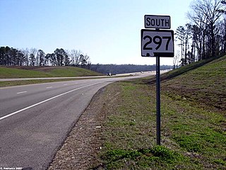
State Route 297 is a short state highway that is just over 1 mile (1.6 km) long highway serving as the fourth Black Warrior River crossing in Tuscaloosa. It acts as a connector between Jack Warner Parkway and Rice Mine Road.
The Paul Bryant Bridge is a four-lane, 150-foot-tall (46 m), $28 million bridge spanning the Black Warrior River along Alabama State Route 297 in Tuscaloosa, Alabama. Construction of the 3,785-foot-long (1,154 m), twin-span bridge commenced in March 2000. Originally slated to open in December 2003, construction delays resulted in its opening on April 23, 2004.
The Woolsey Finnell Bridge is a four-lane, girder bridge spanning the Black Warrior River along U.S. Route 82 in Tuscaloosa, Alabama that opened in 1961. The bridge takes its name from the former state director of highways for Alabama, Woolsey Finnell. This is one of only four vehicular bridges spanning the Black Warrior in Tuscaloosa.

Arcola is a ghost town on the Black Warrior River in what is now Hale County, formerly Marengo County, Alabama. Named to honor the French victory during the Battle of Arcola, it was established in the early 1820s by former French Bonapartists as part of their Vine and Olive Colony, after they were forced to abandon their first town at Demopolis and many found Aigleville unsuitable. The first settler at the site was Frederic Ravesies, who established himself at what later became the Hatch Plantation. Although never more than a village, Arcola became the largest settlement in the colony. Beginning in the 1830s American settlers moved into the area and purchased most of the former French land grants, primarily using Arcola as a river landing. By the 1850s the French settlement had disappeared, replaced by a community of adjoining plantations.
Black Warrior Brewing Company is a craft brewery in Tuscaloosa, Alabama.
DCH Regional Medical Center, originally known as Druid City Hospital and generally referred to as DCH, is a public, not-for-profit hospital and medical complex located in Tuscaloosa, Alabama that serves the West Alabama region. DCH is operated by the DCH Health System, which also runs the Northport Medical Center and the Fayette Medical Center in Northport, Alabama and Fayette, Alabama, respectively. As of 2014, DCH employed 3,481 persons, making it the second highest employer in Tuscaloosa County.
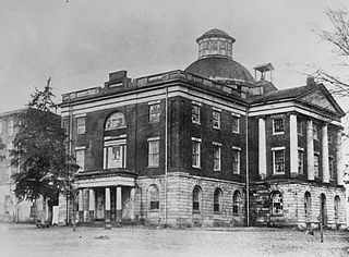
Capitol Park on Childress Hill is a park in Tuscaloosa, Alabama on a bluff above the Black Warrior River. It was the site of the Alabama State Capitol from 1826 to 1846, when the capitol was moved to Montgomery. The capitol building was subsequently used for Alabama Central Female College. It burned in 1923. A historical marker in the park commemorates the school's history. The University of Alabama has a collection of papers related to the school. Classical architecture ruins from the building remain.

