Related Research Articles

Frederick County is located in the Commonwealth of Virginia. As of the 2010 census, the population was 78,305. Its county seat is Winchester. The county was formed in 1743 by the splitting of Orange County. It is Virginia's northernmost county.

Richmond is the capital city of the Commonwealth of Virginia. It is the center of the Richmond Metropolitan Statistical Area (MSA) and the Greater Richmond Region. Richmond was incorporated in 1742 and has been an independent city since 1871. As of the 2010 census, the city's population was 204,214; in 2019, the population was estimated to be 230,436, making Richmond the fourth-most populous city in Virginia. The Richmond Metropolitan Area has a population of 1,260,029, the third-most populous metro in the state.

Powhatan County is a county located in the Commonwealth of Virginia. As of the 2010 census, the population was 28,046. Its county seat is Powhatan.

Goochland County is a county located in the Commonwealth of Virginia. Its southern border is formed by the James River. As of the 2010 census, the population was 21,717. Its county seat is Goochland.

Dinwiddie County is a county located in the Commonwealth of Virginia. As of the 2010 census, the population was 28,001. Its county seat is Dinwiddie.

Chesterfield County is located just south of Richmond in the Commonwealth of Virginia. The county's borders are primarily defined by the James River to the north and the Appomattox River to the south. Its county seat is Chesterfield Court House.

Amelia County is a United States county located just west of Richmond in the Commonwealth of Virginia. The county is included in the Greater Richmond Region, and its county seat is Amelia Courthouse.

Bon Air is a census-designated place (CDP) in Chesterfield County, Virginia, United States. The population was 16,366 at the 2010 census. The community is considered a suburb of the independent city of Richmond in the Richmond-Petersburg region and is a part of the Southside neighborhoods. Originally developed as a resort, a central portion of Bon Air has been designated as a National Historic District with many structures of Victorian design from the late 19th and early 20th centuries. Its name means "good air," reflecting its role as a resort getaway that wealthy Richmonders enjoyed for its fresh air as opposed to the dirty air of Richmond's industrial downtown of the late 19th century.

Chester is a census-designated place (CDP) in Chesterfield County, Virginia, United States. The population was 20,987 at the 2010 census.

Matoaca is a census-designated place (CDP) in Chesterfield County, Virginia, United States. The population was 2,403 at the 2010 census. It is named after the Pamunkey princess Matoaka who was better known by her nickname "Pocahontas". It was near the site of an Appomattoc village Matoka or Matoks, which was reputedly her girlhood home, and the palace town of the weroansqua Oppussoquionuske.

Hamilton is a town in the Loudoun Valley of Loudoun County, Virginia, United States. The population was 506 as of the 2010 census.

The Chesterfield Railroad was located in Chesterfield County, Virginia. It was a 13-mile (21-kilometer) long mule-and-gravity powered line that connected the Midlothian coal mines with wharves that were located at the head of navigation on the James River just below the Fall Line at Manchester. It began operating in 1831 as Virginia's first common carrier railroad.

The Richmond and Danville Railroad (R&D) Company was a railroad that operated independently from 1847 until 1894, first in the U.S. state of Virginia and later on 3,300 miles (5,300 km) of track in nine states.
Midlothian, Virginia is an unincorporated area in Chesterfield County, Virginia, U.S. Settled as a coal town, Midlothian village experienced suburbanization effects and is now part of the western suburbs of Richmond, Virginia south of the James River in the Greater Richmond Region. Because of its unincorporated status, Midlothian has no formal government, and the name is used to represent either the original small Village of Midlothian, located on Midlothian Turnpike (US-60) between Old Buckingham Road and Salisbury Drive, or a vast expanse of Chesterfield County in the northwest portion of Southside Richmond covered by three zip codes served by the Midlothian post office. These zip codes are not coterminous with the Midlothian Magisterial District associated with the Chesterfield County government.

Westham Bridge crossed the James River between Henrico County and Chesterfield County. The bridge was located between Bosher Dam and Williams Island Dam just west of the 7 miles of rapids and falls which constitute the fall line of the James River at Richmond, Virginia.

The Tri-Cities of Virginia is an area in the Greater Richmond Region which includes the three independent cities of Petersburg, Colonial Heights, and Hopewell and portions of the adjoining counties of Chesterfield, Dinwiddie, and Prince George in south-central Virginia. Other unincorporated communities located in the Tri-Cities area include Ettrick, Fort Lee, and City Point, the latter formerly a historic incorporated town which was annexed to become part of the City of Hopewell.
Pony Springs is an unincorporated community in Lincoln County, Nevada, United States. Pony Springs is located along U.S. Route 93.
Glade Springs, West Virginia is an unincorporated community consisting of a gated community and resort located just outside Beckley in Raleigh County, West Virginia.
Chunnenuggee Ridge Public Garden was a botanical garden near Union Springs, Alabama. It was the first public garden in the state. The garden club that established it, Chunnenuggee Ridge Horticultural Society, is the oldest continuously operating garden club in the U.S.
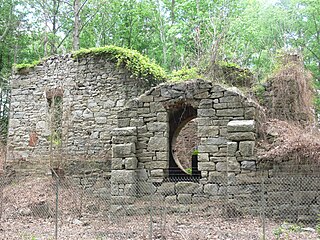
Salisbury was a house and plantation in northwestern Chesterfield County, Virginia in the Southside area of Metro Richmond, Virginia. It was most likely built in the early 1760s by Abraham Salle (c.1732-c.1800), a descendant of Huguenot refugees fleeing persecution in France. Salle's grandfather, also named Abraham (1670-1719), was the immigrant ancestor for most of the Huguenot Salles living in Colonial Virginia. Abraham Salle had "assembled the original 1,500 acre tract between 1760 to 1763" from various parcels of land primarily owned by his uncles William and Robert Wooldridge. The Wooldridge's had inherited the land from their father, John "Blacksmith" Wooldridge (c.1678-1757), himself the immigrant ancestor of all Wooldridges living in the American South.
References
- ↑ Landscape Architecture: An Illustrated History in Timelines, Site Plans and Biography. 1993. p. 355. Retrieved 3 September 2020.
- ↑ Hollywood Cemetery: The History of A Southern Shrine. 1999. p. 13. Retrieved 3 September 2020.
- ↑ Carpenter, Edwin W.; Hamlet, Thomas R. (1988). "Huguenot Springs Cemetery". The United Daughters of the Confederacy Magazine. 51: 41. Retrieved 3 September 2020.
- ↑ Wilkerson, Lyn (2010). Slow Travels-Virginia Edition . Retrieved 3 September 2020.
- ↑ Wilkerson, Lyn (2010). Slow Travels-Virginia Edition . Retrieved 3 September 2020.
Municipalities and communities of Powhatan County, Virginia, United States | ||
|---|---|---|
| CDP |  | |
| Other unincorporated communities | ||
Coordinates: 37°33′32″N77°42′07″W / 37.55889°N 77.70194°W
| This Powhatan County, Virginia state location article is a stub. You can help Wikipedia by expanding it. |