The Gulf of Carpentaria is a sea off the northern coast of Australia. It is enclosed on three sides by northern Australia and bounded on the north by the eastern Arafura Sea, which separates Australia and New Guinea. The northern boundary is generally defined as a line from Slade Point, Queensland in the northeast, to Cape Arnhem on the Gove Peninsula, Northern Territory in the west.

The Torngat Mountains are a mountain range on the Labrador Peninsula at the northern tip of Newfoundland and Labrador and eastern Quebec. They are part of the Arctic Cordillera. The mountains form a peninsula that separates Ungava Bay from the Atlantic Ocean.

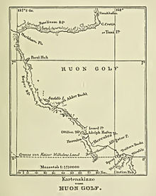
Kaiser-Wilhelmsland formed part of German New Guinea, the South Pacific protectorate of the German Empire. Named in honour of Wilhelm I, who reigned as German Emperor from 1871 to 1888, it included the northern part of present-day Papua New Guinea. From 1884 until 1920 the territory was a protectorate of the German Empire. Kaiser-Wilhelmsland, the Bismarck Archipelago, the northern Solomon Islands, the Caroline Islands, Palau, Nauru, the Northern Mariana Islands, and the Marshall Islands comprised German New Guinea.

Morobe Province is a province on the northern coast of Papua New Guinea. The provincial capital and largest city is Lae. The province covers 33,705 km2, with a population of 674,810, and since the division of Southern Highlands Province in May 2012 it is the most populous province. It includes the Huon Peninsula, the Markham River, and delta, and coastal territories along the Huon Gulf. The province has nine administrative districts. At least 101 languages are spoken, including Kâte and Yabem language. English and Tok Pisin are common languages in the urban areas, and in some areas pidgin forms of German are mixed with the native language.
The Huon Gulf languages are Western Oceanic languages spoken primarily in Morobe Province of Papua New Guinea. They may form a group of the North New Guinea languages, perhaps within the Ngero–Vitiaz branch of that family.
The Markham languages form a family of the Huon Gulf languages. It consists of a dozen languages spoken in the Ramu Valley, Markham Valley and associated valley systems in the lowlands of the Madang and Morobe Provinces of Papua New Guinea. Unlike almost other Western Oceanic languages of New Guinea, which are spoken exclusively in coastal areas, many Markham languages are spoken in the mountainous interior of Morobe Province, Papua New Guinea, where they are in heavy contact with Trans-New Guinea languages.
The Markham Valley is a geographical area in Papua New Guinea. The name "Markham" commemorates Sir Clements Markham, Secretary of the British Royal Geographical Society - Captain John Moresby of the Royal Navy named the Markham River after Sir Clements in the course of his voyage of exploration in HMS Basilisk in 1873. The valley contains two districts of Morobe Province: Huon Gulf district on the east and Markham district on the west. The inhabitants of the valley are of Oceanic (Austronesian) descent and live in large villages under a chieftain political system.

The Markham Valley, Ramu Valley and Finisterre Range campaigns were a series of battles within the broader New Guinea campaign of World War II. The campaigns began with an Allied offensive in the Ramu Valley, from 19 September 1943, and concluded when Allied troops entered Madang on 24 April 1944. During the campaign, Australian forces – supported by Australian and US aircraft – advanced through the Markham Valley and Ramu Valleys during which there were minor clashes with Japanese forces, which withdrew towards their main defensive line in the Finisterre Range.
Bukawa is an Austronesian language of Papua New Guinea.
Kala, also known as Kela, is an Austronesian language spoken by about 2200 people in several villages along the south coast of the Huon Gulf between Salamaua Peninsula and the Paiawa River, Morobe Province, Papua New Guinea.
Aribwatsa, also known as Lae or Lahe, is an extinct member of the Busu subgroup of Lower Markham languages in the area of Lae, Morobe Province, Papua New Guinea. Descendants of the Aribwatsa language community have mostly switched to the Bukawa language, which is spoken all along the north coast of the Huon Gulf and in several villages on the south coast.
The Western Coastal Plains is a strip of coastal plain 50 kilometres in width between the west coast of India and the Western Ghats hills, which starts near the south of the Tapi River. The plains are located between the Western Ghats and the Arabian Sea. The plains begin at Gujarat in the north and end at Kanyakumari in Tamil Nadu, the southern tip of peninsular India. It includes the states of Gujarat, Maharashtra, Goa, Karnataka, Kerala, and a small part of Tamil Nadu. The region consists of three sections: the northern part of the coast is called the Konkan, the central stretch is called the Kanara or the "Karavali", while the southern stretch is referred to as the Malabar Coast. On its northern side there are two gulfs: the Gulf of Khambat and the Gulf of Kutch. The rivers along the coast form estuaries and provide conditions ideal for pisciculture. Because of the presence of less coastal land in this part, it will be affected more by the global warming.
Western Australia has the longest coastline of any state or territory in Australia, at 10,194 km or 12,889 km. It is a significant portion of the coastline of Australia, which is 35,877 km.
On October 31 at 17:53 UTC the island of New Guinea was shaken by an earthquake of magnitude 6.9 that particularly affected the city of Madang on the north coast of Papua New Guinea. Causing between five and eighteen fatalities, it triggered landslides that ran down steep hills into poorly reinforced wooden huts. The area that experienced the most powerful intensity extended 20 kilometers (12 mi) out from the epicenter. Underwater landslides caused minor tsunami over about 100 km of coast and severed underwater cables in several places.
In the Australian state of Tasmania, there are many areas which are commonly known by regional names. Regions are areas that share similar characteristics. These characteristics may be natural such as the Furneaux Islands, the coastline, or the Central Highlands. Alternatively, the characteristics may be cultural, such as a viticulture land use. Tasmania is divided by numerous regional boundaries, based on different characteristics. In many cases boundaries defined by different government agencies are coterminous and are often cited by the Australian and local media that tend to distinguish between North West, West Coast, Southern, and East Coast.

Butibam is a village on the outskirts of Lae, Morobe Province in Papua New Guinea.

The Battle of Madang, fought between early February and late April 1944, was the break-out and pursuit phase of the Markham and Ramu Valley – Finisterre Range and Huon Peninsula campaigns, which were part of the wider New Guinea campaign of World War II. After overcoming the Japanese defences around Shaggy Ridge, the Australian forces descended the steep slopes of the Finisterre Range and pursued the withdrawing Japanese towards Bogadjim and then Madang on the north coast of New Guinea. There they linked up with US and Australian forces that had advanced along the coast from the Huon Peninsula, while the remnants of three Japanese divisions withdrew towards Wewak, where further fighting would take place throughout late 1944 and into 1945.

On September 9, 2002, a magnitude 7.6 earthquake struck off the coast of Wewak, Sandaun Province, Papua New Guinea. The shallow reverse earthquake triggered a local tsunami measuring 5 meters high. The disaster resulted in at least 6 deaths, 70 injuries and building damage.