Hurley, New York

Last updated

Hurley, New York
Town of Hurley
Hurley, NY, town hall.jpg
Hurley Town Hall
Ulster County New York incorporated and unincorporated areas Hurley (town) highlighted.svg
Location in Ulster County and the state of New York.
New York Locator Map with US.PNG
Red pog.svg
Hurley, New York
Coordinates: 41°55′27″N74°03′42″W / 41.92417°N 74.06167°W / 41.92417; -74.06167
CountryUnited States
State New York
County Ulster
Area
[1]
  Total35.97 sq mi (93.15 km2)
  Land29.91 sq mi (77.47 km2)
  Water6.06 sq mi (15.68 km2)  16.74%
Population
 (2020) [2]
  Total6,178
  Density204.91/sq mi (79.12/km2)
Time zone UTC-5 (Eastern (EST))
  Summer (DST) UTC-4 (EDT)
FIPS code 36-111-37143
Website townofhurley.org

Hurley is a town in Ulster County, New York, United States. The population was 6,178 at the 2020 census. [2] The town is in the northeastern part of the county, west of the city of Kingston. Much of the town is inside the Catskill Park. Located within the town is a hamlet and census-designated place, also named Hurley. The Town of Hurley comprises the hamlets of Hurley, West Hurley and Glenford.

Contents

History

In the spring of 1662, Petrus Stuyvesant, Director General of New Netherland, established the village of Niew Dorp on the site of an earlier Native American settlement. On June 7, 1663, during the Esopus Wars the Esopus attacked and destroyed that village, and took captives who were later released. [3] The English acquired the Dutch colony on September 6, 1664. On September 17, 1669, the village, abandoned since the Esopus attack, was resettled and renamed Hurley. It has been stated that the resettled village was named after Francis Lovelace, Baron Hurley of Ireland. [4] However, no such title existed and it is more likely that Lovelace renamed the settlement Hurley somehow in reference to, or solidarity with, his kinsmen and fellow royalists, the Barons Lovelace of Hurley in Berkshire, England (contemporaries as well as modern historians often confuse Francis Lovelace the colonial governor with a son of Richard, 1st Baron Lovelace (1564-1634) of Hurley, Berkshire. This earlier Francis was to be the grandfather of the John Lovelace (1672-1709) a later colonial Governor). In 1708 two large land patents from the New York Colonial government expanded the bounds of Hurley northward to near the present boundary with the Town of Woodstock and southward to the old boundary of the Town of New Paltz. [5]

The southern section was quickly settled by farmers and the villages of Bloomingdale and Wagondale (later Creeklocks) were established. The discovery of limestone suitable for cement made this a valuable economic area and the village of Rosendale became its center. These villages and the surrounding area became the core of the town of Rosendale, established in 1844. [5]

The central part of the town (known sometimes as "Old Hurley") remained an agricultural community of close-knit families. Farming the Esopus Valley, they supplied grain to the growing colony, New England, and the American Revolutionary forces. During October, November, and December 1777, Old Hurley was the military headquarters for General George Clinton's Continental forces and the temporary capital of New York State, moving from Kingston. [5] The town was succeeded by Poughkeepsie as the capital.

Hurley's Main Street Historic homes along Main street, Hurley, New York.jpg
Hurley's Main Street

Old Hurley's Main Street is listed on the National Register of Historic Places due to its well-preserved stone houses which have served as residences for more than 300 years. Some are open to the public once a year in July on Stone House Day, and one contains the Hurley Heritage Society's museum. [6]

Hurley Library Hurley Library and sign, Hurley, New York.jpg
Hurley Library
Hurley Museum Hurley Museum, Hurley, New York.jpg
Hurley Museum

The northern section of the town was a forested wilderness until the discovery, in the 1830s, of a fine quality shale. Known as bluestone, it was used in the construction of road curbing, sidewalks and building facades. West Hurley, Glenford, and Ashton were villages established as a result of the quarry industry. In 1917, New York City's need for a dependable water supply resulted in land condemnation and the flooding of the valley to create the Ashokan Reservoir. The flooded villages of Glenford and West Hurley were resettled on the shores of the reservoir, but Ashton was never relocated. [5]

Parts of Hurley have been used to form the towns of New Paltz (1809), Esopus (1818), Olive (1823), Rosendale (1844), and Woodstock (1853). The southern part of Hurley includes Stony Hollow, New York.

Geography

According to the United States Census Bureau, the town has a total area of 36 square miles (93.2 km2), of which 30 square miles (77.6 km2) is land and 6 square miles (15.6 km2) (16.74%) is water.

Esopus Creek, a tributary of the Hudson River, flows through the town. The eastern part of the Ashokan Reservoir is in the northern part of the town.

U.S. Route 209 passes through the eastern part of the town, and NY 28 crosses it east to west.

Demographics

Historical population
CensusPop.Note
1820 1,352
1830 1,4084.1%
1840 2,20156.3%
1850 2,003−9.0%
1860 2,36418.0%
1870 2,98726.4%
1880 2,521−15.6%
1890 2,135−15.3%
1900 1,903−10.9%
1910 1,734−8.9%
1920 846−51.2%
1930 1,16838.1%
1940 1,53031.0%
1950 1,98029.4%
1960 4,526128.6%
1970 6,49643.5%
1980 6,9927.6%
1990 6,741−3.6%
2000 6,564−2.6%
2010 6,314−3.8%
2020 6,178−2.2%
U.S. Decennial Census [7]

2010 census

As of the 2010 census, there were 6,314 people. The population was 94.5% white, 1.6% black, .1% Native American, 1.4% Asian Asian and .1% Pacific Islander. 2.9% were Latino of any race. [8]

2000 census

As of the census [9] of 2000, there were 6,564 people, 2,694 households, and 1,872 families residing in the town. The population density was 219.2 inhabitants per square mile (84.6/km2). There were 2,946 housing units at an average density of 98.4 per square mile (38.0/km2). The racial makeup of the town was 95.64% white, 1.4% black or African American, .12% Native American, 1.22% Asian, .11% Pacific Islander, .3% from other races, and 1.2% from two or more races. Hispanic or Latino of any race were 1.9% of the population.

There were 2,694 households, out of which 28.9% had children under the age of 18 living with them, 57.8% were married couples living together, 8.0% had a female householder with no husband present, and 30.5% were non-families. 25.0% of all households were made up of individuals, and 11% had someone living alone who was 65 years of age or older. The average household size was 2.41 and the average family size was 2.88.

In the town, the population was spread out, with 22.3% under the age of 18, 4.6% from 18 to 24, 24.5% from 25 to 44, 31.0% from 45 to 64, and 17.6% who were 65 years of age or older. The median age was 44 years. For every 100 females, there were 95.4 males. For every 100 females age 18 and over, there were 89.2 males.

The median income for a household in the town was $51,055, and the median income for a family was $59,487. Males had a median income of $39,565 versus $27,238 for females. The per capita income for the town was $25,864. About 4.4% of families and 6.2% of the population were below the poverty line, including 7.2% of those under age 18 and 5.3% of those age 65 or over.

Notable people

Communities and locations in the Town of Hurley

Related Research Articles

<span class="mw-page-title-main">Ulster County, New York</span> County in New York, United States

Ulster County is a county in the U.S. state of New York. It is situated along the Hudson River. As of the 2020 census, the population was 181,851. The county seat is Kingston. The county is named after the Irish province of Ulster.

<span class="mw-page-title-main">Esopus, New York</span> Town in New York, United States

Esopus is a town in Ulster County, New York, United States. The population was 9,548 at the 2020 census. The town was named after the local indigenous tribe and means "small river" in English. They were one of the Lenape (Delaware) bands, belonging to a people who ranged from western Connecticut through lower New York, western Long Island, and parts of New Jersey and Pennsylvania along the Delaware River. The town is on the west bank of the Hudson River south of the city of Kingston. Its center is in Port Ewen. US Route 9W passes along the eastern side of the town.

<span class="mw-page-title-main">Marbletown, New York</span> Town in New York, United States

Marbletown is a town in Ulster County, New York, United States. The population was 5,658 at the 2020 census. It is located near the center of Ulster County, southwest of the City of Kingston. US 209 and NY 213 pass through the town. It is at the eastern edge of the Catskill Park.

<span class="mw-page-title-main">Olive, New York</span> Town in New York, United States

Olive is a town in Ulster County, New York, United States. The town is west of Kingston, New York and is inside the Catskill Park. The population was 4,226 at the 2020 census.

<span class="mw-page-title-main">Rochester, Ulster County, New York</span> Town in New York, United States

Rochester is a town in Ulster County, New York, United States. The population was 7,272 at the 2020 census. It is an interior town located near the center of Ulster County. The northwestern part of the town is in the Catskill Park.

<span class="mw-page-title-main">Rosendale, New York</span> Town in New York, United States

Rosendale is a town in the center of Ulster County, New York, United States. It once contained a village Rosendale, primarily centered around Main Street, but which was dissolved through vote in 1977. The population was 5,782 at the 2020 census.

<span class="mw-page-title-main">Shandaken, New York</span> Town in New York, United States

Shandaken is a town on the northern border of Ulster County, New York, United States, northwest of Kingston, New York. As of the 2020 census, the town had a total population of 2,866. The name is believed to be from an Esopus phrase for "land of rapid waters."

<span class="mw-page-title-main">Shokan, New York</span> CDP in New York, United States

Shokan is a hamlet located in the town of Olive in Ulster County, New York, United States, within the Catskill Park. The population was 1,075 at the 2020 census.

<span class="mw-page-title-main">Ulster, New York</span> Town in New York, United States

Ulster is a town in Ulster County, New York, United States. The population was 12,660 at the 2020 census.

<span class="mw-page-title-main">West Hurley, New York</span> CDP in New York, United States

West Hurley is a hamlet in Ulster County, New York, United States. The population was 1,917 at the 2020 census.

<span class="mw-page-title-main">Rondout Creek</span> River in New York, United States

Rondout Creek is a 63.3-mile-long (101.9 km) tributary of the Hudson River in Ulster and Sullivan counties, New York, United States. It rises on Rocky Mountain in the eastern Catskills, flows south into Rondout Reservoir, part of New York City's water supply network, then into the valley between the Catskills and the Shawangunk Ridge, where it goes over High Falls and finally out to the Hudson at Kingston, receiving along the way the Wallkill River.

<span class="mw-page-title-main">Ashokan Reservoir</span> New York City reservoir in Catskill Mountains

The Ashokan Reservoir is a reservoir in Ulster County, New York. It is at the eastern end of the Catskill Park, and is one of several in the region created to provide the City of New York with water. It is the city's deepest reservoir at 190 feet (58 m) near the dam at the former site of Bishop Falls.

<span class="mw-page-title-main">Esopus Creek</span> Tributary of the Hudson River in the Catskill region of New York state

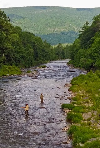
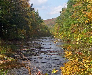
Esopus Creek is a 65.4-mile-long (105.3 km) tributary of the Hudson River that drains the east-central Catskill Mountains in the U.S. state of New York. From its source at Winnisook Lake on the slopes of Slide Mountain, the Catskills' highest peak, it flows across Ulster County to the Hudson at Saugerties. Many tributaries extend its watershed into neighboring Greene County and a small portion of Delaware County. Midway along its length, it is impounded at Olive Bridge to create Ashokan Reservoir, the first of several built in the Catskills as part of New York City's water supply system. Its own flow is supplemented 13 miles (21 km) above the reservoir by the Shandaken Tunnel, which carries water from the city's Schoharie Reservoir into the creek.

<span class="mw-page-title-main">New York State Route 213</span> State highway in Ulster County, New York, US

New York State Route 213 (NY 213) is a state highway located entirely in Ulster County. It runs from the eastern Catskills to downtown Kingston.

<span class="mw-page-title-main">Brown's Station, New York</span> Village in United States of America

Brown's Station was a hamlet in the Esopus Valley of southeastern Ulster County, New York, United States. It was submerged by the waters of the Ashokan Reservoir, an artificial lake built between 1906 and 1915 to supply fresh water to New York City.

The Beaverkill Creek was a former tributary of the Esopus Creek in the Catskill Mountains of New York State. It began in West Hurley, New York, and flowed through the towns of Glenford, Olive Branch and Ashton until it joined the Esopus Creek at Brown's Station, New York. However, the creek was completely submerged when the Ashokan Reservoir was constructed, and its former path is under the east basin. The confluence of the Beaverkill and the Esopus is under the Olivebridge Dam.

<span class="mw-page-title-main">Hurley (CDP), New York</span> CDP in New York, United States

Hurley is a hamlet in the Town of Hurley, Ulster County, New York, United States. The population was 3,346 at the 2020 census.

<span class="mw-page-title-main">Kingston (town), New York</span> Town in Ulster County, New York, US

Kingston is a town in Ulster County, New York, United States. The Town of Kingston is in the northeastern part of Ulster County, north of the City of Kingston. Kingston is inside the Catskill Park. The population was 933 at the 2020 census.

<span class="mw-page-title-main">Saugerties, New York</span> Town in Ulster County, New York, United States

Saugerties is a town in the northeastern corner of Ulster County, New York. The population was 19,038 at the time of the 2020 Census, a decline from 19,482 in 2010. The village of the same name is located entirely within the town.

<span class="mw-page-title-main">Woodstock, New York</span> Town in New York, United States

Woodstock is a town in Ulster County, New York, United States, in the northern part of the county, northwest of Kingston. It lies within the borders of the Catskill Park. The population was 6,287 at the 2020 census, up from 5,884 in 2010.

References

  1. "2016 U.S. Gazetteer Files". United States Census Bureau. Retrieved July 5, 2017.
  2. 1 2 US Census Bureau, Hurley town, Ulster County, New York
  3. Baker, David (April 6, 2005). "A Brief History of Hurley". Archived from the original on August 22, 2007. Retrieved July 5, 2006.
  4. "Profile for Hurley, New York". ePodunk . Retrieved April 27, 2010.
  5. 1 2 3 4 "Town Of Hurley: History: History [Digital Towpath]". Archived from the original on July 4, 2008.
  6. "Stone House Day".
  7. "Census of Population and Housing". Census.gov. Retrieved June 4, 2015.
  8. U.S. Census, 2010, American Factfinder https://factfinder.census.gov/faces/tableservices/jsf/pages/productview.xhtml?src=CF Archived 2011-07-21 at the Wayback Machine Archived 2015-04-11 at the Wayback Machine
  9. "U.S. Census website". United States Census Bureau . Retrieved January 31, 2008.
  10. La Gorce, Tammy (March 24, 2013). "Comic Book Fundamentals". The New York Times . Archived from the original on June 17, 2022.