Palm Beach County is a county located in the southeastern part of Florida and lies directly north of Broward County and Miami-Dade County. The county had a population of 1,492,191 as of the 2020 census, making it the third-most populous county in the state of Florida and the 26th-most populous county in the United States. The largest city and county seat is West Palm Beach. Named after one of its oldest settlements, Palm Beach, the county was established in 1909, after being split from Dade County. The county's modern-day boundaries were established in 1963.

Boynton Beach is a city in Palm Beach County, Florida, United States. It is situated about 57 miles (92 km) north of Miami. The 2020 census recorded a population of 80,380. Boynton Beach is a principal city of the Miami metropolitan area, which was home to 6,138,333 people at the 2020 census. The city is named after Nathan Boynton, a Civil War major and Michigan politician who became one of the first settlers in the area in 1895. Boynton Beach is located north of Delray Beach, south of Hypoluxo and Lantana, and east of Golf, while the municipalities of Briny Breezes, Gulf Stream, Manalapan, and Ocean Ridge are situated to the east across the Intracoastal Waterway.

Canal Point is a census-designated place (CDP) and unincorporated community in Palm Beach County, Florida, United States. Canal Point is located along the eastern shore of Lake Okeechobee, to the northeast of Pahokee and to the northwest of Bryant. The unincorporated community was originally inhabited by the Calusa tribe until almost 400 years ago. Whites began occupying the area in the 1900s decade, establishing an agrarian community. The completion of the West Palm Beach Canal in 1917 allowed crops to be shipped by boat to West Palm Beach and then to other areas of the country, while construction of Conners Highway in 1924 resulted in crops being transported by motor vehicle.

Lake Worth Beach, previously named Lake Worth, is a city in east-central Palm Beach County, Florida, United States, located about 64 miles (103 km) north of Miami. The city's name is derived from the body of water along its eastern border known as the Lake Worth Lagoon, which was named for General William J. Worth, who led United States Army forces during the last part of the Second Seminole War. Lake Worth Beach is situated south of West Palm Beach, southeast of Lake Clarke Shores, east of Palm Springs, and north of Lantana, while a small section of the city also partitions the town of Palm Beach. The 2010 census recorded a population of 34,910, which increased to 42,219 in the 2020 census. Lake Worth Beach is within the Miami metropolitan area, which was home to an estimated 6,138,333 people in 2020.

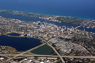
West Palm Beach is a city in and the county seat of Palm Beach County, Florida, United States. It is located immediately to the west of the adjacent Palm Beach, which is situated on a barrier island across the Lake Worth Lagoon. The population was 117,415 at the 2020 census. West Palm Beach is a principal city of the Miami metropolitan area, which was home to 6,138,333 people in 2020. It is the oldest incorporated municipality in the South Florida area, incorporated as a city two years before Miami in November 1894. West Palm Beach is located approximately 68 miles (109 km) north of Downtown Miami.

John Wellborn Martin was an American politician who served as the 24th Governor of Florida, from 1925 to 1929. He also served as Mayor of Jacksonville, Florida, from 1917 to 1923. Born in Plainfield in Marion County, Florida, Martin and his family moved to Jacksonville in 1899. Despite only about four years of formal education, he studied law and was admitted to the Florida Bar in 1914. Three years later, Martin ran for Mayor of Jacksonville and easily defeated incumbent J. E. T. Bowden, becoming the city's youngest mayor at age 32. He was easily re-elected twice in landslide victories and served three consecutive terms.

The Great Miami Hurricane of 1926 was a large and intense tropical cyclone that devastated the Greater Miami area and caused catastrophic damage in the Bahamas and the U.S. Gulf Coast in September of the year 1926, accruing a US$100 million damage toll. As a result of the devastation wrought by the hurricane in Florida, the Land Boom in Florida ended. The hurricane represented an early start to the Great Depression in the aftermath of the state's 1920s land boom. It has been estimated that a similar hurricane would cause about $235 billion in damage if it were to hit Miami in 2018.

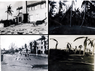
The Okeechobee hurricane of 1928, also known as the San Felipe Segundo hurricane, was one of the deadliest hurricanes in the recorded history of the North Atlantic basin, and the fourth deadliest hurricane in the United States, only behind the 1900 Galveston hurricane, 1899 San Ciriaco hurricane, and Hurricane Maria. The hurricane killed an estimated 2,500 people in the United States; most of the fatalities occurred in the state of Florida, particularly in Lake Okeechobee. It was the fourth tropical cyclone, third hurricane, and only major hurricane of the 1928 Atlantic hurricane season. It developed off the west coast of Africa on September 6 as a tropical depression, but it strengthened into a tropical storm later that day, shortly before passing south of the Cape Verde islands. Further intensification was slow and halted late on September 7. About 48 hours later, the storm strengthened and became a Category 1 hurricane on the Saffir–Simpson hurricane wind scale. Still moving westward, the system reached Category 4 intensity before striking Guadeloupe on September 12, where it brought great destruction and resulted in 1,200 deaths. The islands of Martinique, Montserrat, and Nevis also reported damage and fatalities, but not nearly as severe as in Guadeloupe.

Port Mayaca is a sparsely populated place located in western Martin County, Florida, United States, on the eastern side of Lake Okeechobee.

The 1947 Fort Lauderdale hurricane was a long-lived and an intense tropical cyclone that affected the Bahamas, southernmost Florida, and the Gulf Coast of the United States in September 1947. The fourth Atlantic tropical cyclone of the year, it formed in the eastern Atlantic Ocean on September 4, becoming a hurricane, the third of the 1947 Atlantic hurricane season, less than a day later. After moving south by west for the next four days, it turned to the northwest and rapidly attained strength beginning on September 9. It reached a peak intensity of 145 mph (233 km/h) on September 15 while approaching the Bahamas. In spite of contemporaneous forecasts that predicted a strike farther north, the storm then turned to the west and poised to strike South Florida, crossing first the northern Bahamas at peak intensity. In the Bahamas, the storm produced a large storm surge and heavy damage, but with no reported fatalities.
The 1929 Bahamas hurricane was a high-end Category 4 tropical cyclone whose intensity and slow forward speed led to catastrophic damage in the Bahamas in September 1929, particularly on Andros and New Providence islands. Its erratic path and a lack of nearby weather observations made the hurricane difficult to locate and forecast. The storm later made two landfalls in Florida, killing eleven but causing comparatively light damage. Moisture from the storm led to extensive flooding over the Southeastern United States, particularly along the Savannah River. Across its path from the Bahamas to the mouth of the Saint Lawrence River, the hurricane killed 155 people.

The effects of Hurricane Wilma in Florida resulted in the storm becoming one of the costliest tropical cyclones in Florida history. Wilma developed in the Caribbean Sea just southwest of Jamaica on October 15 from a large area of disturbed weather. After reaching tropical storm intensity on October 17 and then hurricane status on October 18, the system explosively deepened, peaking as the strongest tropical cyclone ever recorded in the Atlantic basin. Wilma then slowly weakened while trekking to the northwest and fell to Category 4 intensity by the time it struck the Yucatán Peninsula on October 22. Thereafter, a strong cold front swept the storm northeastward into Florida on October 24, with landfall occurring near Cape Romano as a Category 3 hurricane with winds of 120 mph (190 km/h). Wilma continued rapidly northeastward into the Atlantic Ocean and became extratropical on October 26.
The 1947 Fort Lauderdale hurricane had widespread impacts in Florida. It produced significant flooding, damage to vegetation, and beach erosion in the Miami metropolitan area. After forming off West Africa on September 2, the storm moved on a parabolic path that brought it through The Bahamas as a Category 3 hurricane on September 16, eventually striking the city of Fort Lauderdale in South Florida as a powerful Category 4 hurricane on the following day. The hurricane later crossed the state, entered the Gulf of Mexico near Naples less than 24 hours later, and went on to strike Louisiana before dissipating on September 21.

The 1949 Florida hurricane, also known as the Delray Beach hurricane, caused significant damage in the southern portions of the state late in the month of August. The second recorded tropical cyclone of the annual hurricane season, the system originated from a tropical wave near the northern Leeward Islands on August 23. Already a tropical storm upon initial observations, the cyclone curved west-northwestward and intensified, becoming a hurricane on August 25. Rapid intensification ensued as the storm approached the central Bahamas early on August 26, with the storm reaching Category 4 hurricane strength later that day and peaking with maximum sustained winds of 130 mph (210 km/h) shortly after striking Andros. Late on August 26, the storm made landfall near Lake Worth, Florida, at the same intensity. The cyclone initially weakened quickly after moving inland, falling to Category 1 status early the next day. Shortly thereafter, the system curved northward over the Nature Coast and entered Georgia on August 28, where it weakened to a tropical storm. The storm then accelerated northeastward and became extratropical over New England by August 29. The remnants traversed Atlantic Canada and much of the Atlantic Ocean before dissipating near Ireland on September 1.

The 1933 Treasure Coast hurricane was the second-most intense tropical cyclone to strike the United States during the active 1933 Atlantic hurricane season. The eleventh tropical storm, fifth hurricane, and the third major hurricane of the season, it formed east-northeast of the Leeward Islands on August 31. The tropical storm moved rapidly west-northwestward, steadily intensifying to a hurricane. It acquired peak winds of 140 mph (220 km/h) and passed over portions of the Bahamas on September 3, including Eleuthera and Harbour Island, causing severe damage to crops, buildings, and infrastructure. Winds over 100 mph (160 km/h) affected many islands in its path, especially those that encountered its center, and many wharves were ruined.

Major Barclay Harding Warburton I was the publisher of the Philadelphia Evening Telegraph.

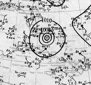
The effects of the 1928 Okeechobee hurricane in Florida included at least 2,500 fatalities in the state, making this the second deadliest tropical cyclone on record in the contiguous United States, behind only the 1900 Galveston hurricane, as well as the deadliest weather event on the East Coast of the United States. The storm originated from a tropical depression that developed near Senegal on September 6. Traversing westward across the Atlantic Ocean, the cyclone struck the Lesser Antilles, Puerto Rico, and the Bahamas as a powerful hurricane. Early on September 17, the storm made landfall near Palm Beach, Florida, as a Category 4 hurricane on the modern-day Saffir–Simpson scale. After initially moving northwestward across Florida, the cyclone curved north-northeastward near the Tampa Bay area. The hurricane briefly re-emerged into the Atlantic prior to striking South Carolina on September 18 and becoming extratropical over North Carolina on the next day, before the remnants lost their identity over Ontario on September 21.
The history of West Palm Beach, Florida, began more than 5,000 years ago with the arrival of the first aboriginal natives. Native American tribes such as the Jaegas inhabited the area. Though control of Florida changed among Spain, England, the United States, and the Confederate States of America, the area remained largely undeveloped until the 20th century. By the 1870s and 1880s, non-Native American settlers had inhabited areas in the vicinity of West Palm Beach and referred to the settlement as "Lake Worth Country". However, the population remained very small until the arrival of Henry Flagler in the 1890s. Flagler constructed hotels and resorts in Palm Beach to create a travel destination for affluent tourists, who could travel there via his railroad beginning in 1894.

Woodlawn Cemetery is located at 1301 South Dixie Highway in West Palm Beach, Florida. It consists of three cemeteries: Woodlawn Cemetery, the Jewish Cemetery, and Woodlawn Cemetery North.
Palm Beach County is a county in the southeastern part of the U.S. state of Florida. Its history dates back to about 12,000 years ago, shortly after when Native Americans migrated into Florida. Juan Ponce de León became the first European in the area, landing at the Jupiter Inlet in 1513. Diseases from Europe, enslavement, and warfare significantly diminished the indigenous population of Florida over the next few centuries. During the Second Seminole War, the Battles of the Loxahatchee occurred west of modern-day Jupiter in 1838. The Jupiter Lighthouse, the county's oldest surviving structure, was completed in 1860. The first homestead claims were filed around Lake Worth in 1873. The county's first hotel, schoolhouse, and railway, the Celestial Railroad, began operating in the 1880s, while the first settlers of modern-day Lake Worth Beach arrived in 1885. During the 1890s, Henry Flagler and his workers constructed the Royal Poinciana Hotel and The Breakers in Palm Beach and extended the Florida East Coast Railway southward to the area. They also developed a separate city for hotel workers, which in 1894 became West Palm Beach, the county's oldest incorporated municipality. Major Nathan Boynton, Congressman William S. Linton, and railroad surveyor Thomas Rickards also arrived in the 1890s and developed communities that became Boynton Beach, Delray Beach, and Boca Raton, respectively.


