The Faroe Islands is served by an internal transport system based on roads, ferries, and helicopters. As of the 1970s, the majority of the population centres of the Faroe Islands have been joined to a single road network, connected by bridges and tunnels.
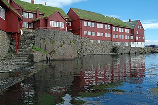
Tórshavn, usually locally referred to as simply Havn, is the capital and largest city of the Faroe Islands. It is located in the southern part on the east coast of Streymoy. To the northwest of the city lies the 347-meter-high (1,138 ft) mountain Húsareyn, and to the southwest, the 350-meter-high (1,150 ft) Kirkjubøreyn. They are separated by the Sandá River. The city itself has a population of 14,065 (2023), and the greater urban area has a population of 23,194, including the suburbs of Hoyvík and Argir.
This is a timeline of Faroese history comprising important legal and territorial changes and political events in Iceland and its predecessor states. To read about the background to these events, see history of the Faroe Islands.

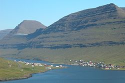
Klaksvík is the second largest town of the Faroe Islands behind Tórshavn. The town is located on Borðoy, which is one of the northernmost islands. It is the administrative centre of Klaksvík municipality.

Kirkja is a village on the island of Fugloy, Faroe Islands. It is located on the south-tip of the island, and its land is stretching all over the western side of the island, including a small enclave in the now uninhabited Skarðsvík. Here archaeologists have located an old settlement that has probably been only a part-time settlement used either by people from Kirkja or Hattarvík.

Leirvík is a town on the Faroe Islands and was an important regional ferry harbour at the east coast of the second-largest island Eysturoy. Leirvík has a population of 1,027 (2023).
Posta is the postal service of the Faroe Islands and was founded on 1 April 1976 under the Home Rule of the Faroe Islands. On 16 December 2005, it became a public joint stock company under the name P/F Postverk Føroya.
The Faroese mass media consists of several newspapers, radio stations, magazines, as well as a local TV station, Kringvarp Føroya.

Viðareiði is the northernmost settlement in the Faroe Islands and lies on the Island of Viðoy, which belongs to the Norðoyar Region.

Sumba is the southernmost village of the Faroe Islands, located on the island of Suðuroy. It is located in Sumbiar Municipality.

Kollafjørður is a village in the Faroe Islands, located on the island of Streymoy. As of 1. January 2022, the village had a population of 828. Its postal code is FO 410. Until 2001 it was a municipality in its own right but is now part of the Tórshavn Municipality. It is located 21.8 kilometres (13.5 mi) by road north of Tórshavn, and stretches 7 km (4.3 mi) along the fjord of the same name.
Jákup Pauli Gregoriussen is the leading architect of the Faroe Islands. He is also a graphic artist and author of publications about the Faroese church.
Norðtoftir is a small settlement on the Faroese island of Borðoy in the Hvannasund municipality. The 2023 population was 3. Its postal code is FO 736.

The following outline is provided as an overview of and topical guide to the Faroe Islands:
The Faroe or Faeroe Islands, or simply the Faroes, are an archipelago in the North Atlantic Ocean and an autonomous territory of the Kingdom of Denmark. The official language of the country is Faroese, which is closely related to and partially mutually intelligible with Icelandic.
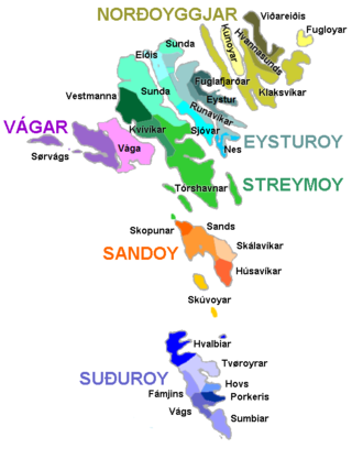
The Faroe Islands are administratively divided in 29 municipalities (kommunur), with about 120 cities and villages. Until December 31, 2008, there were 34 municipalities, and until December 31, 2004, there were 48 municipalities. In the coming years the number of Faroese municipalities is expected to drop to somewhere between 7 and 15, as there is currently a rationale towards municipal amalgamation and a decentralization of public services. In 1998 it was suggested that no municipality should have fewer than 2,000 inhabitants, but whether this will be true is a political question. The Faroese government has furthermore decided not to conduct forced, top-down amalgamation, but to leave the process to the free will of the municipalities. In many small municipalities there is some resistance to the amalgamation process, and as a result two kinds of municipalities are being created: large municipalities (town-municipalities) that are eager to attract smaller municipalities into amalgamation, and small municipalities which are either trying to avoid amalgamation or seek to amalgamate with other small municipalities. The geographically large Sunda municipality is an example of this. The larger municipalities are organized in Kommunusamskipan Føroya (KFS) and the smaller are organized in Føroya Kommunufelag (FKF).

Syðradalur (Faroese pronunciation:[ˈsiːɹaˌdɛalʊɹ], is a village on the island of Kalsoy, one of the Faroe Islands.

The levels of education in the Faroe Islands are primary, secondary and higher education. Most institutions are funded by the state; there are few private schools in the country. Education is compulsory for 9 years between the ages of 7 and 16.

Christianskirkjan is a modern church building in Klaksvík, the second-largest town in the Faroe Islands. It was consecrated in 1963. The architect was Peter Koch, a Dane. Aesthetically, it is one of the islands’ most notable modern buildings in the country.
The COVID-19 pandemic was confirmed to have reached the Faroe Islands, an autonomous territory of Denmark, in March 2020. The confirmed infection rate was 1 case per 280 inhabitants, one of the highest rates in the world, but the archipelago also tested at a very high frequency, with the number of tests equaling c. 34 per cent of the population. As of 28 February 2022, there have been 34648 confirmed cases. Among these, 31 persons have died with COVID-19.