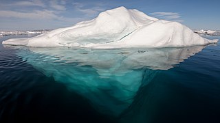
An iceberg is a piece of freshwater ice more than 15 m long that has broken off a glacier or an ice shelf and is floating freely in open (salt) water. Smaller chunks of floating glacially derived ice are called "growlers" or "bergy bits". Much of an iceberg is below the water's surface, which led to the expression "tip of the iceberg" to illustrate a small part of a larger unseen issue. Icebergs are considered a serious maritime hazard.

An ice shelf is a large platform of glacial ice floating on the ocean, fed by one or multiple tributary glaciers. Ice shelves form along coastlines where the ice thickness is insufficient to displace the more dense surrounding ocean water. The boundary between the ice shelf (floating) and grounded ice is referred to as the grounding line; the boundary between the ice shelf and the open ocean is the ice front or calving front.

The Filchner–Ronne Ice Shelf or Ronne–Filchner Ice Shelf is an Antarctic ice shelf bordering the Weddell Sea.

Berkner Island is an Antarctic ice rise, where bedrock below sea level has caused the surrounding ice sheet to create a dome. If the ice cap were removed, the island would be underwater. Berkner Island is completely ice-covered and is about 320 kilometres (200 mi) long and 150 kilometres (93 mi) wide, with an area of 44,000 km2 (17,000 sq mi). It is surrounded by the Filchner-Ronne Ice Shelf. The northernmost point of the Berkner is about 20 kilometres (12 mi) from the open sea. It lies in the overlapping portion of the Argentine and the British Antarctic territorial claims.

The Larsen Ice Shelf is a long ice shelf in the northwest part of the Weddell Sea, extending along the east coast of the Antarctic Peninsula from Cape Longing to Smith Peninsula. It is named after Captain Carl Anton Larsen, the master of the Norwegian whaling vessel Jason, who sailed along the ice front as far as 68°10' South during December 1893. In finer detail, the Larsen Ice Shelf is a series of shelves that occupy distinct embayments along the coast. From north to south, the segments are called Larsen A, Larsen B, and Larsen C by researchers who work in the area. Further south, Larsen D and the much smaller Larsen E, F and G are also named.

The Brunt Ice Shelf borders the Antarctic coast of Coats Land between Dawson-Lambton Glacier and Stancomb-Wills Glacier Tongue. It was named by the UK Antarctic Place-names Committee after David Brunt, British meteorologist, Physical Secretary of the Royal Society, 1948–57, who was responsible for the initiation of the Royal Society Expedition to this ice shelf in 1955.

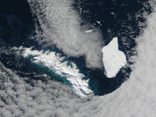
Iceberg B-15 was the largest recorded iceberg by area. It measured around 295 by 37 kilometres, with a surface area of 11,000 square kilometres, about the size of the island of Jamaica. Calved from the Ross Ice Shelf of Antarctica in March 2000, Iceberg B-15 broke up into smaller icebergs, the largest of which was named Iceberg B-15-A. In 2003, B-15A drifted away from Ross Island into the Ross Sea and headed north, eventually breaking up into several smaller icebergs in October 2005. In 2018, a large piece of the original iceberg was steadily moving northward, located between the Falkland Islands and South Georgia Island. As of August 2023, the U.S. National Ice Center (USNIC) still lists one extant piece of B-15 that meets the minimum threshold for tracking. This iceberg, B-15AB, measures 20 km × 7 km ; it is currently grounded off the coast of Antarctica in the western sector of the Amery region.

The Amery Ice Shelf is a broad ice shelf in Antarctica at the head of Prydz Bay between the Lars Christensen Coast and Ingrid Christensen Coast. It is part of Mac. Robertson Land. The name "Cape Amery" was applied to a coastal angle mapped on 11 February 1931 by the British Australian New Zealand Antarctic Research Expedition (BANZARE) under Douglas Mawson. He named it for William Bankes Amery, a civil servant who represented the United Kingdom government in Australia (1925–28). The Advisory Committee on Antarctic Names interpreted this feature to be a portion of an ice shelf and, in 1947, applied the name Amery to the whole shelf.

Mertz Glacier is a heavily crevassed glacier in George V Coast of East Antarctica. It is the source of a glacial prominence that historically has extended northward into the Southern Ocean, the Mertz Glacial Tongue. It is named in honor of the Swiss explorer Xavier Mertz.

Luitpold Coast is that portion of the coast of Coats Land extending from the vicinity of Hayes Glacier, at 27°54′W, to 36°W, which is regarded as the eastern limit of the Filchner Ice Shelf. It was discovered by Wilhelm Filchner, leader of the Second German Antarctic Expedition, 1911–12, and named after Luitpold, Prince Regent of Bavaria.

Iceberg B-9 was an iceberg that calved from Antarctica in 1987. It measured 154 kilometres (96 mi) long and 35 kilometres (22 mi) wide; it had a total area of 5,390 square kilometres (2,080 sq mi), and is one of the longest icebergs ever recorded. This calving took place immediately east of the future calving site of Iceberg B-15; it carried away Little America V which had been closed in December 1959. Starting in October 1987, Iceberg B-9 drifted for 22 months, covering 2,000 kilometres (1,200 mi) on its journey. Initially, B-9 moved northwest for seven months, before being drawn southward by a subsurface current that eventually led to its colliding with the Ross Ice Shelf in August 1988. It then made a 100-kilometre (62 mi) radius gyre before resuming its northwest drift. It moved at an average speed of 2.5 kilometres (1.6 mi) per day over the continental shelf, as measured by NOAA-10 and DMSP satellite positions, and by the ARGOS data buoy positions. In early August 1989, B-9 broke into three large pieces north of Cape Adare. These pieces were designated as B-9A, 56 by 35 kilometres, B-9B, 100 by 35 kilometres, and B-9C, 28 by 13 kilometres.

The Second German Antarctic Expedition of 1911–1913 was led by Wilhelm Filchner in the exploration ship Deutschland. Its principal objective was to determine whether the Antarctic continent comprised a single landmass rather than separated elements, and in particular whether the Weddell Sea and Ross Sea were connected by a strait. In addition, an extensive programme of scientific research was undertaken. The expedition failed to establish a land base, and the ship became beset in the Weddell Sea ice, drifting north for eight months before reaching open water. The expedition was marred by considerable disagreement and animosity among its participants, and broke up in disarray.
Pobeda Ice Island, original Russian name остров Победы, is an ice island in the Mawson Sea. It is located 160 km (99 mi) off the coast of Queen Mary Land, East Antarctica. This island, which exists periodically, is formed by the running aground of a tabular iceberg.

Ice calving, also known as glacier calving or iceberg calving, is the breaking of ice chunks from the edge of a glacier. It is a form of ice ablation or ice disruption. It is the sudden release and breaking away of a mass of ice from a glacier, iceberg, ice front, ice shelf, or crevasse. The ice that breaks away can be classified as an iceberg, but may also be a growler, bergy bit, or a crevasse wall breakaway.

Ellsworth Scientific Station was a permanent, all year-round originally American, then Argentine Antarctic scientific research station named after American polar explorer Lincoln Ellsworth. It was located on Gould Bay, on the Filchner Ice Shelf.

Iceberg A-68 was a giant tabular iceberg adrift in the South Atlantic, having calved from Antarctica's Larsen C ice shelf in July 2017. By 16 April 2021, no significant fragments remained.
Filchner Station was a German research station in the Antarctic. Administered by the Alfred Wegener Institute for Polar and Marine Research, it was established in February 1982 on the Filchner–Ronne Ice Shelf. The first station in Antarctica to be mounted on jacks, the structure was raised each year to allow for the increase in height of the shelf by snowfall. It was also relocated around 1 kilometre (0.62 mi) southwards each year to account for drift of the ice shelf. In October 1998, Filchner Station was stranded on iceberg A-38 when it broke away from the ice shelf. Research operations were cancelled and an emergency salvage operation was carried out that removed the majority of the station by February 1999.

Iceberg A-74 is an iceberg that calved from the north side of the Antarctic Brunt Ice Shelf in February 2021. Its calving had been anticipated due to large ice rifts that opened up in September 2019 and spread in the Antarctic summer of 2020–21. The iceberg measured 1,270 square kilometres (490 sq mi) soon after calving. It has moved away from the Antarctic coast which allowed, on 13–14 March 2021, the research vessel Polarstern to complete a circumnavigation as part of a research expedition. The Polarstern has photographed the sea bed which has provided an insight into fauna that can survive up to 30 kilometres (19 mi) from the nearest daylight.
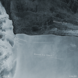
In mid-May 2021, A-76 was, before it broke into three, the world's largest floating iceberg, calved from the Filchner–Ronne Ice Shelf in Antarctica.