Related Research Articles
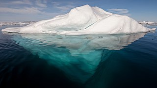
An iceberg is a piece of freshwater ice more than 15 m long that has broken off a glacier or an ice shelf and is floating freely in open (salt) water. Smaller chunks of floating glacially-derived ice are called "growlers" or "bergy bits". Both are generally spawned from disintegrating icebergs. Iceberg size classes, as established by the International Ice Patrol, are summarized in Table 1. The 1912 loss of the RMS Titanic led to the formation of the International Ice Patrol in 1914. Much of an iceberg is below the surface, which led to the expression "tip of the iceberg" to illustrate a small part of a larger unseen issue. Icebergs are considered a serious maritime hazard.

The climate of Antarctica is the coldest on Earth. The continent is also extremely dry, averaging 166 mm (6.5 in) of precipitation per year. Snow rarely melts on most parts of the continent, and, after being compressed, becomes the glacier ice that makes up the ice sheet. Weather fronts rarely penetrate far into the continent, because of the katabatic winds. Most of Antarctica has an ice-cap climate with very cold, generally extremely dry weather.
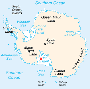
The Ross Ice Shelf is the largest ice shelf of Antarctica. It is several hundred metres thick. The nearly vertical ice front to the open sea is more than 600 kilometres (370 mi) long, and between 15 and 50 metres high above the water surface. Ninety percent of the floating ice, however, is below the water surface.

The Filchner-Ronne Ice Shelf, also known as Ronne-Filchner Ice Shelf, is an Antarctic ice shelf bordering the Weddell Sea.

The Larsen Ice Shelf is a long ice shelf in the northwest part of the Weddell Sea, extending along the east coast of the Antarctic Peninsula from Cape Longing to Smith Peninsula. It is named after Captain Carl Anton Larsen, the master of the Norwegian whaling vessel Jason, who sailed along the ice front as far as 68°10' South during December 1893. In finer detail, the Larsen Ice Shelf is a series of shelves that occupy distinct embayments along the coast. From north to south, the segments are called Larsen A, Larsen B, and Larsen C by researchers who work in the area. Further south, Larsen D and the much smaller Larsen E, F and G are also named.

McMurdo Sound and its ice-clogged waters extends about 55 kilometres (34 mi) long and wide. The sound connects the Ross Sea to the north with the Ross Ice Shelf cavity to the south via Haskell Strait. The strait is largely covered by the McMurdo Ice Shelf. The Royal Society Range rises from sea level to 4,205 metres (13,796 ft) on the western shoreline. Ross Island, an historic jumping-off point for polar explorers, designates the eastern boundary. The active volcano Mount Erebus at 3,794 metres (12,448 ft) dominates Ross Island. Antarctica's largest scientific base, the United States' McMurdo Station, as well as the New Zealand Scott Base are on the southern shore of the island. Less than 10 percent of McMurdo Sound's shoreline is free of ice. It is the southernmost navigable body of water in the world.

The Antarctic ice sheet is one of the two polar ice caps of the Earth. It covers about 98% of the Antarctic continent and is the largest single mass of ice on Earth. It covers an area of almost 14 million square kilometres and contains 26.5 million cubic kilometres of ice. A cubic kilometer of ice weighs approximately one metric gigaton, meaning that the ice sheet weighs 26,500,000 gigatons. Approximately 61 percent of all fresh water on the Earth is held in the Antarctic ice sheet, an amount equivalent to about 58 m of sea-level rise. In East Antarctica, the ice sheet rests on a major land mass, while in West Antarctica the bed can extend to more than 2,500 m below sea level.

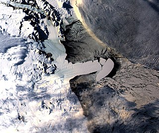
Iceberg B-15 was the largest recorded iceberg by area. It measured around 295 kilometres (183 mi) long and 37 kilometres (23 mi) wide, with a surface area of 11,000 square kilometres (4,200 sq mi)—larger than the whole island of Jamaica. Calved from the Ross Ice Shelf of Antarctica in March 2000, Iceberg B-15 broke up into smaller icebergs, the largest of which was named Iceberg B-15-A. In 2003, B-15A drifted away from Ross Island into the Ross Sea and headed north, eventually breaking up into several smaller icebergs in October 2005. In 2018, a large piece of the original iceberg was steadily moving northward, located between the Falkland Islands and South Georgia Island. As of 2021, the U.S. National Ice Center (USNIC) still lists one extant piece of B-15 that meets the minimum threshold for tracking. This iceberg, B-15ab, is 11 nautical miles long and 4 nautical miles wide; it is currently grounded off the coast of Antarctica in the western sector of the Amery region.
The Drygalski Ice Tongue or Drygalski Barrier or Drygalski Glacier Tongue is a glacier in Antarctica, on the Scott Coast, in the northern McMurdo Sound of Antarctica's Ross Dependency, 240 kilometres (150 mi) north of Ross Island. The Drygalski Ice Tongue is stable by the standards of Antarctica's icefloes, and stretches 70 kilometres (43 mi) out to sea from the David Glacier, reaching the sea from a valley in the Prince Albert Mountains of Victoria Land. The Drygalski Ice Tongue ranges from 14 to 24 kilometres wide.

The Amery Ice Shelf is a broad ice shelf in Antarctica at the head of Prydz Bay between the Lars Christensen Coast and Ingrid Christensen Coast. It is part of Mac. Robertson Land. The name "Cape Amery" was applied to a coastal angle mapped on February 11, 1931, by the British Australian New Zealand Antarctic Research Expedition (BANZARE) under Douglas Mawson. He named it for William Bankes Amery, a civil servant who represented the United Kingdom government in Australia (1925–28). The Advisory Committee on Antarctic Names interpreted this feature to be a portion of an ice shelf and, in 1947, applied the name Amery to the whole shelf.

Mertz Glacier is a heavily crevassed glacier in George V Coast of East Antarctica. It is the source of a glacial prominence that historically has extended northward into the Southern Ocean, the Mertz Glacial Tongue. It is named in honor of the Swiss explorer Xavier Mertz.

Thwaites Glacier, sometimes referred to as the Doomsday Glacier, is an unusually broad and vast Antarctic glacier flowing into Pine Island Bay, part of the Amundsen Sea, east of Mount Murphy, on the Walgreen Coast of Marie Byrd Land. Its surface speeds exceed 2 kilometres per year near its grounding line. Its fastest flowing grounded ice is centred between 50 and 100 kilometres east of Mount Murphy. It was named by the Advisory Committee on Antarctic Names in 1967 after Fredrik T. Thwaites (1883–1961), a glacial geologist, geomorphologist and professor emeritus at the University of Wisconsin–Madison. The historian Reuben Gold Thwaites was his father.

Iceberg B-9 was an iceberg that calved from Antarctica in 1987. It measured 154 kilometres (96 mi) long and 35 kilometres (22 mi) wide; they had a total area of 5,390 square kilometres (2,080 sq mi), and is one of the longest icebergs ever recorded. This calving took place immediately east of the future calving site of Iceberg B-15; it carried away Little America V which had been closed in December 1959. Starting in October 1987, Iceberg B-9 drifted for 22 months, covering 2,000 kilometres (1,200 mi) on its journey. Initially, B-9 moved northwest for seven months, before being drawn southward by a subsurface current that eventually led to its colliding with the Ross Ice Shelf in August 1988. It then made a 100-kilometre (62 mi) radius gyre before resuming its northwest drift. It moved at an average speed of 2.5 kilometres (1.6 mi) per day over the continental shelf, as measured by NOAA-10 and DMSP satellite positions, and by the ARGOS data buoy positions. In early August 1989, B-9 broke into three large pieces north of Cape Adare. These pieces were designated as B-9A, 56 by 35 kilometres, B-9B, 100 by 35 kilometres, and B-9C, 28 by 13 kilometres.
The Erebus Ice Tongue is a mountain outlet glacier and the seaward extension of Erebus Glacier from Ross Island. It projects 11 kilometres (6.8 mi) into McMurdo Sound from the Ross Island coastline near Cape Evans, Antarctica. The glacier tongue varies in thickness from 50 metres (160 ft) at the snout to 300 metres (980 ft) at the point where it is grounded on the shoreline. Explorers from Robert F. Scott's Discovery Expedition (1901–1904) named and charted the ice tongue.

Ice calving, also known as glacier calving or iceberg calving, is the breaking of ice chunks from the edge of a glacier. It is a form of ice ablation or ice disruption. It is the sudden release and breaking away of a mass of ice from a glacier, iceberg, ice front, ice shelf, or crevasse. The ice that breaks away can be classified as an iceberg, but may also be a growler, bergy bit, or a crevasse wall breakaway.

Wilkins Sound is a seaway in Antarctica that is largely occupied by the Wilkins Ice Shelf. It is located on the southwest side of the Antarctic Peninsula between the concave western coastline of Alexander Island and the shores of Charcot Island and Latady Island farther to the west.

A-38 was a large iceberg that split from the Filchner-Ronne Ice Shelf in Antarctica in October 1998. Soon after formation it split into two pieces, A-38A and A-38B, which drifted westwards on the Weddell Gyre. The icebergs moved north along the Antarctic Peninsula and reached its tip in February 2003. A-38A and A-38B increased speed in open sea and grounded in shallower waters to the east of South Georgia Island in December 2003. A-38A broke up into three pieces in March 2004 and drifted north where it decayed. A-38B split into two in April, with the eastern portion, now known as A-38G, drifting north and west to decay. The remainder of A-38B remained grounded, interfering with the foraging routes of seals and penguins in South Georgia, resulting in the deaths of their young. On 20 August A38-B broke into two, with the new portion drifting north and breaking up. The remainder of A-38B continued to break up through September 2004 and had completely decayed by 2005.

Liu Yan is a Chinese Antarctic researcher best known for her work on iceberg calving. She is an Associate Professor of geography in the College of Global Change and Earth System Science (GCESS) and Polar Research Institute, Beijing Normal University.

Iceberg A-68 was a giant tabular iceberg adrift in the South Atlantic, having calved from Antarctica's Larsen C ice shelf in July 2017. By 16 April 2021 no significant fragments remained.
References
- ↑ New City-sized Iceberg Created Near Antarctica. LiveScience, 27 March 2006.