Ida-Viru County

Last updated
Ida-Viru County
Ida-Virumaa
Narva asv2022-04 img09 Castle.jpg
Ida-Virumaa vapp.svg
Ida-Viru County in Estonia.svg
CountryEstonia
Capital Jõhvi
Largest town Narva
Area
[1]
  Total2,972 km2 (1,147 sq mi)
Population
 (2022) [1]
  Total132,736
  Rank 3rd
  Density45/km2 (120/sq mi)
Ethnicity
   Russians 73.2%
   Estonians 18.4%
   Ukrainians 2.4%
  other5.7%
GDP
[2]
  Total€2.631 billion (2022)
  Per capita€19,778 (2022)
ISO 3166 code EE-45
Vehicle registration I

Ida-Viru County ("East Viru county". Estonian : Ida-Viru maakond or Ida-Virumaa) is one of 15 counties of Estonia. It is the most north-eastern part of the country. The county contains large deposits of oil shale - the main mineral mined in Estonia. Oil shale is used in the production of shale oil and in thermal power plants. The capital of the county is the town of Jõhvi which is administratively united with the Jõhvi Parish; nevertheless, Narva is the largest town in the county in terms of population and at the same time the third largest city in Estonia after Tallinn and Tartu.

Contents

In January 2019 Ida-Viru County had a population of 136,240 – constituting 10.3% of the total population in Estonia. [1] [3] It borders Lääne-Viru County in the west, Jõgeva County in the southwest and Russia (Leningrad Oblast) in the east. It is the only county in Estonia where Russians constitute the majority of population (73.1% in 2010), the second highest being Harju (28%).

History

During the latter part of the period of Soviet rule of Estonia, Ida-Virumaa was called Kohtla-Järve district, and its administrative capital was Kohtla-Järve.

County Government (Estonian : maavalitsus), led by a governor (Estonian : maavanem), ceased to exist after administrative reform in 2017. The last governor of Ida-Viru county was Andres Noormägi. [4]

Demographics

The population of Ida-Viru county declined from 221,807 in 1990 to 168,656 in 2010. Population of Ida-Viru county (1990-2010).png
The population of Ida-Viru county declined from 221,807 in 1990 to 168,656 in 2010.

In January 2017, the population of Ida-Virumaa was 143,880, which makes it the third largest county in Estonia (after Harju and Tartu counties, which include the capital Tallinn and country's second-largest city Tartu). 44.6% of the population are men and 55.4% women. [3]

By January 2020, the population of Ida-Virumaa had decreased to 134,259, of which 33% were of native origin and 67% of foreign origin. [5]

As a result of mass migration from the Soviet Union, Ida-Viru County is now the only county in Estonia where ethnic Russians have largely replaced the indigenous Estonian population.

By ethnic origin, on 1 January 2017, 73.1% of the population were Russians, 18.9% were Estonians, 2.3% were Ukrainians, 2.1% were Belarusians and 0.9% were Finns. [3]

According to Estonian 2021 census population of Ida-Virumaa was 132,741. By ethnic origin 97,231 (73.25%) were Russians, 24,490 (18.45%) were Estonians, 3,265 (2.46%) Ukrainians, 2,720 (2.05%) were Belarusians 1,065 (0.80%) were Finns. [6]

Religion

Religion in Ida-Viru County (2021)

Religious affiliations in Ida-Viru County, census 2000–2021* [7]
Religion200020112021
Number %Number %Number %
Christianity 54,26936.263,14148.958,53050.6
Orthodox Christians 43,30228.555,84042.253,18046.0
Lutherans 7,9465.34,6233.62,4402,1
Catholics 1,1450.78150.61,1100.9
Baptists 6750.43790.22000.1
Jehovah's Witnesses 2820.23420.23200.2
Pentecostals 5040.33180.24000.3
Old Believers 1080.0071580.11300.1
Methodists 1720.11400.11600.1
Adventists 1350.11110.1800.1
—Other Christians--4150.25100.4
Islam --2440.27000.6
Buddhism --350.02300.02
Other religions**5900.34380.27400.6
No religion 50,55133.742,75433.140,25034.8
Not stated***44,36229.522,43617.415,40013.3
Total population*150,049129,049115,650
*The censuses of Estonia count the religious affiliations of the population older than 15 years of age. [7]

Municipalities

Ida-Virumaa County is subdivided into eight municipalities, of which four are urban (Estonian : linnad — cities or towns) and four are rural (Estonian : valladparishes). There are 217 villages in Ida-Virumaa.

Municipalities of Ida-Viru County Ida-Viru municipalities 2017.png
Municipalities of Ida-Viru County
RankMunicipalityTypePopulation
(2018) [8]
Area
km2 [8]
Density [8]
1 Alutaguse Parish Rural4,9291,4653.4
2 Jõhvi Parish Rural11,64512493.9
3 Kohtla-Järve Urban35,39539907.6
4 Lüganuse Parish Rural8,94259914.9
5 Narva Urban58,61085689.5
6 Narva-Jõesuu Urban4,82841111.7
7 Sillamäe Urban13,406111,218.7
8 Toila Parish Rural4,80726618.1

Landmarks

Related Research Articles

<span class="mw-page-title-main">Counties of Estonia</span> First-level administrative subdivisions of Estonia

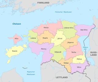
Counties are the state administrative subdivisions of Estonia. Estonian territory is composed of 15 counties, including 13 on the mainland and 2 on islands. County governments were abolished at the end of 2017, with their duties split between state authorities and local governments, and nowadays counties have no noteworthy independent competences. Counties are composed of municipalities of two types: urban municipalities and rural municipalities, which are by law required to cooperate in development of their county.

<span class="mw-page-title-main">Harju County</span> County of Estonia

Harju County, is one of the fifteen counties of Estonia. It is situated in Northern Estonia, on the southern coast of the Gulf of Finland, and borders Lääne-Viru County to the east, Järva County to the southeast, Rapla County to the south, and Lääne County to the southwest. The capital and largest city of Estonia, Tallinn, is situated in Harju County. Harju County is the largest county in Estonia in terms of population, as almost half (45%) of the Estonia's population lives in Harju County.

<span class="mw-page-title-main">Järva County</span> County of Estonia

Järva County is one of 15 counties of Estonia. It is situated in the central part of the country and borders Lääne-Viru County to the east, Jõgeva County to the south-east, Viljandi County to the south, Pärnu County to the south-west, Rapla County to the west, and Harju County to the north. In January 2009, Järva County had a population of 29,940 – constituting 2.7% of the total population in Estonia.

<span class="mw-page-title-main">Rapla County</span> County of Estonia

Rapla County is one of the fifteen counties of Estonia. It is situated in the western part of the country and borders Järva County to the east, Pärnu County to the south, Lääne County to the west, and Harju County to the north. In 2022 Rapla County had a population of 33,529 – constituting 2.5% of the total population of Estonia.

<span class="mw-page-title-main">Lääne-Viru County</span> County of Estonia

Lääne-Viru County is one of 15 counties of Estonia. It is in northern Estonia, on the south coast of the Gulf of Finland. In Estonian, lääne means western and ida means east or eastern. Lääne-Viru borders Ida-Viru County to the east, Jõgeva County to the south, and Järva and Harju counties to the west. In January 2013, Lääne-Viru County had a population of 58,806: 4.5% of the population in Estonia.

<span class="mw-page-title-main">Kohtla-Järve</span> City in Estonia

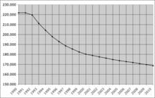
Kohtla-Järve is a city and municipality in northeastern Estonia, founded in 1924 and incorporated as a town in 1946. The city is highly industrial, and is both a processor of oil shales and is a large producer of various petrochemical products. During the 1944–1991 Soviet occupation, large numbers of immigrant workers from Russia and other parts of the former USSR were brought in to populate the rapidly growing city. The population in the Kohtla-Järve area which had been, as of 1934 census, over 90% ethnic Estonian, became overwhelmingly non-Estonian in the second half of the 20th century. According to more recent data 21% of the city's population are ethnic Estonians; most of the rest are Russians. Kohtla-Järve is the fifth-largest city in Estonia in terms of population.

<span class="mw-page-title-main">Jõhvi</span> Town in Estonia

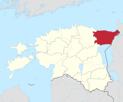
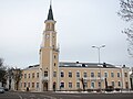
Jõhvi is a town in northeastern Estonia, and the administrative centre of the Ida-Viru County and Jõhvi Parish. The town is situated about 50 km west of the Estonia–Russia international border.

The coats of arms of the 15 counties of Estonia are presented below.

<span class="mw-page-title-main">Ida-Virumaa FC Alliance</span> Estonian football club

Ida-Virumaa FC Alliance is an Estonian football club operating in Ida-Viru County. They play in the Esiliiga, the second highest level of Estonian football league pyramid. The club was created in 2012, when Kohtla-Järve JK Alko and Kohtla-Järve FC Lootus joined together. Before 2021, the team was called Kohtla-Järve JK Järve.

Viru Keemia Grupp (VKG) is an Estonian holding group of oil shale industry, power generation, and public utility companies.

<span class="mw-page-title-main">Toila Parish</span> Municipality in Estonia

Toila Parish is an Estonian municipality located in Ida-Viru County. It has a population of 4,735 (2019) and an area of 266 km².

<span class="mw-page-title-main">Northern Estonia</span> Geographic region in Estonia

Northern Estonia is a geographical region of Estonia, consisting of the three northernmost counties - Harju County, Ida-Viru County and Lääne-Viru County. The largest towns of Northern Estonia are Tallinn, Narva, Kohtla-Järve and Rakvere. Northern Estonia is the most populous area in Estonia, with 60.3% of the population living there.

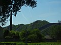
Pajualuse is a village in Jõhvi Parish, Ida-Viru County in northeastern Estonia. It is located about 4 km (2 mi) southwest of the town of Jõhvi and 2 km west of Ahtme, district of Kohtla-Järve, by the Jõhvi–Tartu–Valga road (E264). The entrance of the Viru oil shale mine is located to the south, in Kalina. As of the 2011 census, Pajualuse's population was 50.

Tammiku may refer to several places in Estonia:

Pauliku is a village in Jõhvi Parish, Ida-Viru County in northeastern Estonia. It is located just southwest of the town of Jõhvi and northwest of Ahtme, district of Kohtla-Järve. Pauliku is bordered by the Tallinn–Narva railway to the north and Tammiku spoil tip to the south. As of the 2011 census, the settlement's population was 70.

<span class="mw-page-title-main">Kukruse</span> Village in Estonia

Kukruse is a village in Toila Parish, Ida-Viru County in northeastern Estonia. It is located by the Tallinn–Narva road (E20), between the cities of Kohtla-Järve and Jõhvi. Adjacent to the village is a district of Kohtla-Järve sharing the same name, Kukruse.

Tallinn-Narva maantee is a 212-kilometre-long west-east national main road in Estonia. The road is part of the European route E20. The road forms a major transport west-south transport route between Russia and Europe. The highway starts in Tallinn and passes a number of major Estonian cities and towns, namely Rakvere, Kohtla-Järve, Jõhvi and Sillamäe. The highway ends in Narva on Friendship Bridge, with a border crossing to Russia over the Narva river.

Põhimaantee 3 is a 220-kilometre-long north-south national main road in Estonia. The route follows the same path as the European route E264. The highway starts in Jõhvi. From there the main cities passed are Ahtme and Tartu. The highway ends in Valga on the intersection with the T6.

<span class="mw-page-title-main">Jaan Kalviste</span> Estonian chemist

Jaan Kalviste was an Estonian chemist, mineralogist, educator, and translator.

References

  1. 1 2 3 "Population number, area and density. administrative division as at 01.01.2018". Statistics Estonia. Retrieved 30 July 2022.
  2. "GROSS DOMESTIC PRODUCT BY COUNTY". stat.ee.
  3. 1 2 3 "Population by sex, ethnic nationality and County, 1 January". stat.ee. Statistics Estonia. 2010-04-19. Retrieved 2010-08-19.
  4. "Maavanem". Archived from the original on 15 March 2017. Retrieved 24 September 2015.
  5. "Rv071: Native and Foreign-Origin Population by County After the 2017 Administrative Reform, Sex and Age, 1 January".
  6. "Rl21429: Population by Ethnic Nationality, Sex, Age Group and Place of Residence (Administrative Unit), 31 December 2021".
  7. 1 2 Official census data from Statistics Estonia:
  8. 1 2 3 "Elanike demograafiline jaotus maakonniti". Kohaliku omavalitsuse portaal. Archived from the original on 2 March 2019. Retrieved 2 April 2018.

59°13′N27°18′E / 59.217°N 27.300°E / 59.217; 27.300