Idrakpur Fort

Last updated

Idrakpur Fort
ইদ্রাকপুর দুর্গ
Munshiganj, Bangladesh
idraakpur durg 04.jpg
Idrakpur Fort
Site information
Controlled by Department of Archaeology (Bangladesh)
Open to
the public
Yes
Site history
Built1660 AD
Built by Mir Jumla II

Idrakpur Fort is a river fort situated in Munshiganj, Bangladesh. The fort was built approximately in 1660 A.D. According to a number of historians, the river fort was built by Mir Jumla II, a Subahdar of Bengal under the Mughal Empire, to establish the control of Mughal Empire in Munsiganj, and to defend Dhaka and Narayanganj from the pirates. [1]

Contents

The fort was a part of the triangular defence strategy for the vulnerable river route, from where the pirates used to attack Dhaka. The strategy was developed by Mir Jumla II with the help of the other two forts in Narayanganj- the Hajiganj Fort and the Sonakanda Fort. [2]

Background

Entrance to the fort idraakpur durg 08.jpg
Entrance to the fort

Mughals took over the control of the Bengal in 1574 AD after defeating Daud Khan Karrani. Mughals exercised a progressive rule in Bengal. Bengal was then a very wealthy province and was frequently attacked by the pirates.

The Mughal Empire was then locked into a civil war regarding the succession of Emperor Shah Jahan. Shah Shuja, the second son of Shah Jahan and the Subahdar of Bengal, led a campaign to Agra to take over the throne. Aurangzeb, after his accession to the throne wanted to appoint a man with high skills in naval warfare as the river-oriented Bengal was the strong hold of Shah Shuja. So he entrusted Mir Muhammad Saeed Ardestani alias Mir Jumla II who was a successful trader in maritime trades in first life, to deal with Shah Shuja.

Mir Jumla II rushed to the Bengal compelling Shah Shuja to retreat. Later, Mir Jumla II was appointed as the Subahdar or the governor of the then Bengal province in 1660.

Mir Jumla was aware of the pirates who used to run a campaign of terror in the important cities of Bengal. After his appointment as the Subahdar, he shifted the capital of Bengal to Dhaka from Rajmahal. In a quest to protect the capital Dhaka from the pirates, Mir Jumla II developed a triangular defence strategy and decided to build up three river forts near Dhaka. [2] One of these three forts is Idrakpur Fort of Munshiganj. [1]

History

Idrakpur, now Munshiganj was a strategically very significant point as it was the junction of a number of rivers including Meghna River, Shitalakshya River, Ichhamati River and Dhaleshwari River. [3] The fort was built on the bank of the junction of Ichhamati River and Meghna River.

The Portuguese and Magh pirates used this point to move forward to Dhaka through Shitalakshya River. On their way to Dhaka they used to loot other important cities like Sonargaon and Bikrampur. [4]

Mir Jumla II was determined to protect Dhaka and eager to develop the wealthy area Bikrampur. So, he came up with a triangular defence strategy to protect the cities from the Portuguese pirates. [2]

Idrakpur Fort was the centre of his strategy. The erection of the fort was intended to check the advance of the Magh and Portuguese pirates proceeding towards the Mughal capital city of Dhaka. The fort was also used as the naval base of the naval fleet of 200 frigates under Mughal admiral Abul Hossain. [2]

According to the strategy, whenever the pirates made an attempt to advance to Dhaka the Mughal soldiers would be ordered to start firing mortars both from the cannons of their 200 battleships and from the Idrakpur Fort leaving the pirates with no options but to retreat or die on the rivers.

However, if any of the pirate ships survived the initial attack and tried to advance to Dhaka the Sonakanda Fort and the Hajiganj Fort, situated on the eastern and western bank of Shitalakshya River respectively, would start throwing round-shots to those ships and vessels and sink all the pirate ships on the river. [1]

It was probably built in about 1660 A.D.

Idrakpur Fort Panorama.jpg
Idrakpur Fort

Architecture

Idrakpur river-fort is different from the other Mughal forts and has a number of unique features.

The fort is apparently divided into two parts- the eastern part and the western part. The quadrangular eastern part and the polygonal western part combined into the complete fort. [5]

The brick built fort comprises a wider open area surrounded by wall with bastions at the angles. [6] The thick wall runs from north to south measuring 86.87-meter in length and 59.60-meter in width. The wall has machicolations from where the enemies on the river was targeted and the mortars were fired. There are a number of towers from where the movement of the enemies were observed. [5]

The most significant feature of the fort is the circular drum it has in the eastern part of the fort. The circular drum is further enclosed by another fortification wall, which was used for mounting a huge cannon. [6] The elevated circular drum of 32.5-meter in diameter and 9.14-meter high and can be reached by a staircase. [7] The drum comprises three subsequent layers.

Another remarkable feature of the fort is the existence of a staircase leading to a secret room at the foot of the drum. The staircase leads to a secret underground chamber which was the magazine or storehouse for arms and explosives. According to some myth the staircase was a part of the secret tunnel linked with Lalbagh Fort.

The main entrance gate of the fort is on the north with a high rectangular bastion crowned by machicolated merlons which served as a guard room. [7]

See also

Related Research Articles

<span class="mw-page-title-main">Shah Shuja (Mughal prince)</span> Mughal prince and Governor of Bengal (1616–1661)

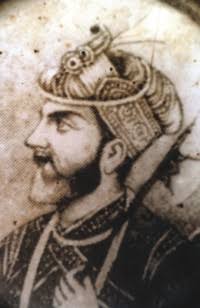
Mirza Shah Shuja was the second son of the Mughal Emperor Shah Jahan and Empress Mumtaz Mahal. He was the governor of Bengal and Odisha and had his capital at Dhaka, in present day Bangladesh.

<span class="mw-page-title-main">Isa Khan</span> Chief of Baro-Bhuiyans of Bengal

Isa Khan was the leader of the 16th-century Baro-Bhuiyan chieftains of Bengal. During his reign, he successfully unified the chieftains of Bengal and resisted the Mughal invasion of Bengal. It was only after his death that the region fell totally under Mughal control. He remains an iconic figure throughout West Bengal and Bangladesh as a symbol of his rebellious spirit and unity.

<span class="mw-page-title-main">Sonargaon</span> Historic city in central Bangladesh

Sonargaon is a historic city in central Bangladesh. It corresponds to the Sonargaon Upazila of Narayanganj District in Dhaka Division.

<span class="mw-page-title-main">Dhaka District</span> District in Dhaka, Bangladesh

Dhaka District is a district in central Bangladesh, and is the densest district in the nation. It is a part of the Dhaka Division. Dhaka, the capital of Bangladesh, and rests on the eastern banks of the Buriganga River which flows from the Turag to the southern part of the district. While Dhaka occupies only about a fifth of the area of Dhaka district, it is the economic, political and cultural centre of the district and the country. Dhaka District consists of Dhaka, Keraniganj, Nababganj, Dohar, Savar and Dhamrai upazila. Dhaka District is an administrative entity, and like many other cities, it does not cover the modern conurbation which is Greater Dhaka, which has spilled into neighbouring districts, nor does the conurbation cover the whole district, as there are rural areas within the district.

<span class="mw-page-title-main">History of Dhaka</span> History of the capital city of Bangladesh

Dhaka (Dacca) is a modern megacity with origins dating to circa the 7th century CE. The history of Dhaka begins with the existence of urbanised settlements that were ruled by the Hindu Gauda Kingdom, Buddhist and Shaivite Pala Empire before passing to the control of the Hindu Sena dynasty in the 10th century CE. After the Sena dynasty, the city was ruled by the Hindu Deva Dynasty.

<span class="mw-page-title-main">Bara Katra</span> Historical and architectural monument in Dhaka, Bangladesh

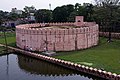
Bara Katra is one of the oldest historical and architectural monuments in Dhaka. The word Katra may have originated from Arabic word Katara which means colonnaded building. 'Katra/ katara' in Arabic and Persian means 'Caravan (Karwan) Sarai' or simply a 'Sarai'. It is a palatial building dating to the reign of the Mughal dynasty in the Bengal region. It is situated to the south of Chowk Bazaar close to the north bank of the river Buriganga. It was partially demolished in 2022.

<span class="mw-page-title-main">Shaista Khan</span> 17th century Mughal general and provincial governor

Mirza Abu Talib, better known as Shaista Khan, was a Moghul General and the Subahdar of Mughal Bengal, he was maternal uncle to the Moghul Emperor Aurangzeb, he acted as a key figure during his reign, Shaista Khan initially governed the Deccan, where he clashed with the Maratha ruler Shivaji, However, he was most notable for his tenure as the governor of Bengal from 1664 to 1688, Under Shaista Khan's authority, the city of Dhaka and Mughal power in the province attained its greatest heights. His achievements include constructions of notable mosques such as the Sat Gambuj Mosque and masterminding the conquest of Chittagong. Shaista Khan was also responsible for sparking the outbreak of the Anglo-Mughal War with the English East India Company.

<span class="mw-page-title-main">Bandar Upazila</span> Upazila in Dhaka, Bangladesh

Bandar is an upazila (sub-district) of the Narayanganj District in central Bangladesh, part of the Dhaka Division. Bandar is a part of Greater Dhaka; the conurbation surrounding the Bangladeshi capital city of Dhaka.

<span class="mw-page-title-main">Shitalakshya River</span> River in Bangladesh

Shitalakshya River is a distributary of the Brahmaputra. A portion of its upper course is known as Banar River or Banor River. In the Shitalakshya's initial stages, it flows in a southwest direction and then east of the city of Narayanganj in central Bangladesh until it merges with the Dhaleswari near Kalagachhiya. The river is about 110 kilometres (68 mi) long and at it widest, near Narayanganj, it is 300 metres (980 ft) across. Its flow, measured at Demra, has reached 74 cubic metres per second (2,600 cu ft/s). It remains navigable year round. The Shitalakshya flows through Gazipur district forming its border with Narsingdi for some distance and then through Narayanganj District.

<span class="mw-page-title-main">Mir Jumla II</span> Grand Vizier under the Mughal Emperor

Mir Jumla II, or Amir Jumla, also known as Ardistānī Mir Muhammad, was a military general, wealthy diamond trader, a Vizier of Golconda sultanate, and later a prominent subahdar of Bengal under the Mughal Emperor Aurangzeb.

<span class="mw-page-title-main">Hajiganj Fort</span>

Hajiganj Fort, also known as Khizirpur fort, situated at Hajiganj locality of Narayanganj, Bangladesh, on the western bank of Shitalakshya.

<span class="mw-page-title-main">Bengal Subah</span> Subdivision of the Mughal Empire

The Bengal Subah, also referred to as Mughal Bengal, was the largest subdivision of the Mughal Empire encompassing much of the Bengal region, which includes modern-day Bangladesh, the Indian state of West Bengal, and some parts of the present-day Indian states of Bihar, Jharkhand and Odisha between the 16th and 18th centuries. The state was established following the dissolution of the Bengal Sultanate, a major trading nation in the world, when the region was absorbed into the Mughal Empire. Bengal was the wealthiest region in the Indian subcontinent.

<span class="mw-page-title-main">Mir Jumla's invasion of Assam</span>

Mir Jumla II invaded the Ahom kingdom in January 1662 and left it in January–February 1663. He was able to occupy Garhgaon, the Ahom capital, before the beginning of the rainy season, but he and his army were confined mostly to Garhgaon and Madhupur during that period. The Ahom king Sutamla had to take flight and hide in Namrup during Mir Jumla's occupation of the capital. The defection of Baduli Phukan, a high ranking Ahom commander, precipitated the Treaty of Ghilajharighat in January 1663, with the Ahom king accepting tributary status. Mir Jumla died on his way back before he could reach Dhaka, his capital.

<span class="mw-page-title-main">Battle of Khajwa</span>

The Battle of Khajuha was fought on January 5, 1659, between the newly crowned Mughal Emperor Aurangzeb and Shah Shuja who also declared himself Mughal Emperor in Bengal. Shuja's army rested by the tank of Khajwa, about 30 miles to the west of Fatehpur- Haswa in'the Allahabad District, between the Ganges and the Jumna.

<span class="mw-page-title-main">Lalbagh Fort</span> Historical site in Dhaka, Bangladesh

Lalbagh Fort is a fort in the old city of Dhaka, Bangladesh. Its name is derived from its neighborhood Lalbagh, which means Red Garden. The term Lalbagh refers to reddish and pinkish architecture from the Mughal period. The original fort was called Fort Aurangabad. Its construction was started by Prince Muhammad Azam Shah, who was the son of Emperor Aurangzeb and a future Mughal emperor himself. After the prince was recalled by his father, the fort's construction was overseen by Shaista Khan. The death of Shaista Khan's daughter Pari Bibi resulted in a halt to the construction process, apparently due to Shaista Khan's superstition that the fort brought bad omen. Pari Bibi was buried inside the fort.

<span class="mw-page-title-main">Sonakanda Fort</span>

Sonakanda Fort is a river fort situated in Narayanganj, Bangladesh, on the eastern bank of Shitalakshya River. Though the time of its establishment could not be ascertained, historians believe that the river fort was built by Mir Jumla II, a Subahdar of Bengal under the Mughal Empire, to defend Dhaka and Narayanganj from pirates.

<span class="mw-page-title-main">Dhaka Gate</span> Historical City Gate in Dhaka, Bangladesh

Dhaka Gate also known as Mir Jumla's Gate or Ramna Gate is a monument believed to be built by Mir Jumla II and enlisted as one of the oldest Mughal architectures in Dhaka. This gate is considered as one of the integral parts of the history of Dhaka.

<span class="mw-page-title-main">Narayanganj City Corporation</span> Local governing body of Narayanganj, Banglades

Narayanganj City Corporation established in 2011, is one of the city corporations of Bangladesh. It was formed comprising Narayanganj Town, Siddhirganj Municipal area and Kadamrasul Municipality.

<span class="mw-page-title-main">Tanda, Bengal</span> 16th-century city of Bengal in South Asia

Tanda, also known as Tandah and Khwaspur Tandah, was a historic 16th-century city of Bengal in the eastern part of South Asia, and one of the most prominent medieval capitals; serving the Karrani Sultans of Bengal and the early Mughal governors of Bengal.

<span class="mw-page-title-main">Mughal conquest of Chittagong</span> Mughal victory in Chittagong

Mughal conquest of Chittagong refers to the conquest of Chittagong in 1666. On 27 January 1666 AD, the Arakan Kingdom of Mrauk U was defeated by the Mughal forces under the command of Buzurg Ummed Khan, the son of Mughal Subedar Shaista Khan.

References

  1. 1 2 3 Sahanaoyaja, AKM (26 January 2015). সাংস্কৃতিক ঐতিহ্য [Cultural Heritage]. Daily Jugantor (in Bengali). Archived from the original on 29 January 2015. Retrieved 2 February 2015.
  2. 1 2 3 4 Ali Imam (2009). জাহাঙ্গীরনগর থেকে ঢাকা (in Bengali). সৃজনী.
  3. মুন্সীগঞ্জের ইদ্রাকপুর কেল্লা [Munshiganj Idrakpur Stronghold]. The Sangbad (in Bengali). 14 November 2013. Retrieved 2 February 2015.
  4. ইদ্রাকপুর দুর্গ হতে পারে আকর্ষণীয় পর্যটন কেন্দ্র [Idrakpur fortress could be attractive tourist center]. Alokito Bangladesh (in Bengali). 27 August 2013. Archived from the original on 2 February 2015. Retrieved 2 February 2015.
  5. 1 2 ইদ্রাকপুর জলদুর্গ [Idrakpur jaladurga]. Priyo.com (in Bengali). 7 April 2013. Archived from the original on 2 February 2015. Retrieved 2 February 2015.
  6. 1 2 Syed Mahmudul Hasan (1980). Muslim Monuments of Bangladesh. Islamic Foundation.
  7. 1 2 Khan, Muazzam Hussain (2012). "Idrakpur Fort". In Islam, Sirajul; Jamal, Ahmed A. (eds.). Banglapedia: National Encyclopedia of Bangladesh (Second ed.). Asiatic Society of Bangladesh.

23°32′51″N90°32′02″E / 23.5474°N 90.5340°E / 23.5474; 90.5340