
The Ruben M. Benjamin House is a house in Bloomington, Illinois. It is a two-story rectangular building, styled in the Classical Revival architectural motif. It was built in 1856 John L. Routt, who would become the first governor of Colorado. Ruben M. Benjamin, an attorney known for litigation relating to railroad regulation, lived in the home for more than 60 years. The United States National Register of Historic Places added the Ruben M. Benjamin House in August 1978.

Buffalo Grove Lime Kiln is one of two old lime kilns in Illinois listed on the National Register of Historic Places. The other is the Griggsville Landing Lime Kiln in Pike County. Buffalo Grove Lime Kiln is located near the Ogle County city of Polo. When in use, the kiln would have produced raw quicklime. The lime kiln was added to the National Register in 2002.
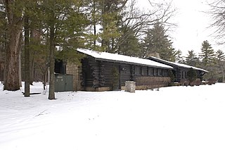
The White Pines State Park Lodge and Cabins are located in rural Ogle County, Illinois near the village of Mount Morris. They were added to the National Register of Historic Places in 1985. The Cabins are one of two Historic Places found in or near Mount Morris, the other is the Samuel M. Hitt House. The Lodge and Cabins are part of a National Register Multiple Property Submission, they were submitted with several other state park lodges, all designed by Joseph F. Booton.
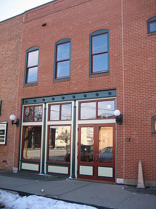
The building at 302 Washington St. in Oregon, Illinois is part of trio of historic Italianate commercial buildings within the boundaries of the Oregon Commercial Historic District from 300-306 Washington. The structure acts mostly as a hallway area between the buildings at 300 Washington St. and the F.G. Jones Block. The interior and exterior have been significantly restored on all three buildings. As part of the Commercial Historic District 300 Washington Street was added to the National Register of Historic Places in August 2006.

As of 2007 there are five church buildings in the Sycamore Historic District, located in Sycamore, Illinois, United States which are listed as contributing properties to the district. The Sycamore Historic District was added to the U.S. National Register of Historic Places on May 2, 1978. When it was nominated to join the National Register there were seven church buildings within the district. One of those included is a residential structure that was utilized as a church when it was first constructed; the Arthur Stark House was once home to the Sycamore Universalist Church congregation. In the time since its listing, two churches have been destroyed or demolished. The Evangelical Lutheran Church of St. John was destroyed by fire in 2004 and the United Methodist Church in Sycamore is no longer extant, replaced by a modern office building.

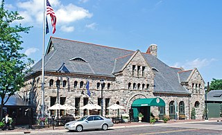
Amboy station is a former rail station in the city of Amboy, Lee County, Illinois, United States. The building was constructed as a headquarters building for the Illinois Central Railroad as well as a public train station for the fledgling city of Amboy in 1876. It was designed by railroad staff architect James Nocquet after a fire destroyed the original Illinois Central offices on the site. The building was added to the U.S. National Register of Historic Places in 1992 as the Amboy Illinois Central Depot.

The Lake–Peterson House, also known as Jenny's, is a Victorian Gothic Revival home in Rockford, Illinois, United States. The house was built in 1873, probably by prominent Rockford citizen John Lake - its first owner, but its architect is unknown. The house is a significant example of Gothic Revival architecture and is considered one of the finest such homes in the U.S. state of Illinois. The Lake–Peterson House is owned and maintained by Swedish American Hospital in Rockford and stands adjacent to the main hospital complex along Business US 20. The building and its carriage house were added to the U.S. National Register of Historic Places in 1980.

The Nachusa House is a former hotel building in Dixon, Illinois, United States along Galena Avenue. The building was constructed in 1853 and operated continuously as a hotel until 1988. It underwent many alterations during the time it operated as a hotel. Following its period as a hotel the five-story mansard roofed building fell into disrepair and was nearly demolished in 1997. The building was restored by the Illinois Housing Development Authority and a Chicago developer at a cost of US$3.2 million and renovated into affordable housing for senior citizens. During its height the Nachusa House was a popular stop along rail and stagecoach lines and was a known layover for Abraham Lincoln. The Nachusa House was added to the U.S. National Register of Historic Places in 1983.

The Lena Water Tower is a water tower located in the village of Lena, Illinois, United States. It was built in 1896 following two decades of problems with structure fires in the village. The current water tower is the result of a second attempt after the first structure proved to be unstable. The tower stands 122.5 feet (37.3 m) tall and is built of limestone and red brick. The current stainless steel water tank holds 50,000 gallons and replaced the original wooden tank in 1984. The site has two other structures, an old power plant building and a 100,000 US gallon reservoir. The Lena Electric Plant Building was constructed in 1905 and the reservoir completed in 1907. The Lena Water Tower was listed on the U.S. National Register of Historic Places in 1997; the reservoir was included as a contributing property to the listing.

Buffalo Grove is an unincorporated community in the Ogle County township of Buffalo, Illinois, United States. It was the first settlement in Ogle County, and was once a bustling frontier town that attracted many of Ogle County's early residents. The creation of the Illinois Central Railroad, caused most of the residents and businesses to move to Polo. Today this former hub of business comprises a few dozen homes.

The Hares Hill Road Bridge is a single-span, wrought iron, bowstring-shaped lattice girder bridge. It was built in 1869 by Moseley Iron Bridge and Roof Company and is the only known surviving example of this kind. The bridge spans French Creek, a Pennsylvania Scenic River.
The Ninth Street Seven Arch Stone Bridge was a historical bridge in Lockport, Illinois. The bridge was the region's first over the Des Plaines River, facilitating trade between farmers west of the river and merchants in Lockport. Farmers were previously forced to use a ford, located near 9th Street. It was approved on March 20, 1868, and cost $4,000. The arch bridge was constructed using locally quarried limestone in eight to twelve inch blocks. Each arch of the bridge spanned 197 foot (60 m). The builder is unknown, but may have been Julius Scheibe, a notable local mason who built many of the city's stone structures of the era. Schiebe was also a highway commissioner during the bridge's construction. A concrete slab had to be added to the foundation of the bridge in the early 1900s due to increased water levels caused by the Chicago Sanitary and Ship Canal. The Ninth Street Seven Arch Stone Bridge was closed to traffic in 1971 and was added to the National Register of Historic Places in 2004.
The Chicago, Rock Island and Pacific Railroad Stone Arch Viaduct, also known as the Old Stone Arch, is located northeast of Shelby, Iowa, United States. The span carried the Chicago, Rock Island and Pacific Railroad tracks over Little Silver Creek. It measures 35 feet (11 m) from the water level to the deck, 20 feet (6.1 m) in width, and 30 feet (9.1 m) in length. The bridge has flanking wingwalls that measure 40 feet (12 m) in length. Limestone for the bridge was quarried near Earlham, Iowa and transported by train to the site. It is one of two such bridges known to exist in Shelby County. The Rock Island was the first railroad to enter the county, and continued to operate here into the 1950s. At that time they abandoned the line when the Atlantic cutoff was built providing a more direct route between Atlantic, Iowa and Council Bluffs. While the tracks were removed, the stone arch, the railroad grade, and the right-of-way were left intact. They are now part of the Rock Island Old Stone Arch Nature Trail. The bridge was listed on the National Register of Historic Places in 1998.

The Chicago & North Western Railway Stone Arch Bridge, also known as the Kinnikinnick Creek Railway Bridge, is a historic Chicago and North Western Railway bridge that crosses South Kinnikinnick Creek east of Roscoe, Illinois. The bridge was built in 1882 to replace a wooden bridge; the line it was on opened in 1853 as part of the Galena and Chicago Union Railroad and originally connected Belvidere, Illinois and Beloit, Wisconsin. C&NW Chief Engineer Van Mienen designed the double arch dolomitic limestone bridge, which is 53 feet (16 m) long, 60 feet (18 m) wide, and 58 feet (18 m) high. The railroad allowed the sand quarrying industry in Roscoe and South Beloit to ship its products to construction sites in Chicago; the bridge is one of the few surviving remnants of the railroad in Roscoe. The bridge is the only stone-faced rubble fill bridge with more than one arch in Winnebago County; the nearest bridge of the type is a five-arch bridge in Tiffany, Wisconsin.

The Hawkeye Street Underpass is a historic structure located south of Nora Springs, Iowa, United States. It spans South Hawkeye Street for 28 feet (8.5 m). The Illinois Central Railroad arrived in Nora Springs in 1868, and the Burlington, Cedar Rapids & Northern Railway (BCR&N) arrived three years later. The later was acquired by the Chicago, Rock Island & Pacific Railroad in the early 1880s. This stone masonry arch underpass was constructed by the Rock Island Line in 1889 as part of an upgrade of the tracks. It was designed by F.A. McDonald who had worked for the BCR&N. It is the only known stone arch bridge in Floyd County. The bridge was listed on the National Register of Historic Places in 1998.

The West Sixth Street Bridge is a historic stone arch bridge in downtown Austin, Texas. Built in 1887, the bridge is one of the state's oldest masonry arch bridges. It is located at the site of the first bridge in Austin, carrying Sixth Street across Shoal Creek to link the western and central parts of the old city. The bridge was added to the National Register of Historic Places in 2014.

The Indian Lake Road Stone Arch Bridge is a former railroad bridge which now carries a hiking/biking path over Indian Lake Road, just east of M-24 near Orion, Michigan. It is one of only a small number of stone arch railroad bridges known to exist in Michigan. The bridge was listed on the National Register of Historic Places in 2005.
The Ann Arbor station is a former Michigan Central Railroad station located at 401 Depot Street in Ann Arbor, Michigan. It was converted into a restaurant, the Gandy Dancer, in 1970, and listed on the National Register of Historic Places as Michigan Central Railroad Depot in 1975.

The Mill Street–South Branch Raisin River Bridge is a bridge carrying Mill Street over the South Branch of the River Raisin in Brooklyn, Michigan. It was listed on the National Register of Historic Places in 2000.

Old Bridge, also known as the Historic Village of Old Bridge, is an unincorporated community located within East Brunswick in Middlesex County, in the U.S. state of New Jersey. It is on the South River, a tributary of the Raritan River. The community is named after the first bridge built here to cross the river, the South River Bridge. After other bridges were built crossing the river, it became known as the Old Bridge. The Old Bridge Historic District, encompassing much of the village, is listed on the state and national registers of historic places.


