
Amador County is a county located in the U.S. state of California, in the Sierra Nevada. As of the 2020 census, the population was 40,474. The county seat is Jackson. Amador County, located within California's Gold Country, is known as "The Heart of the Mother Lode". There is a substantial viticultural industry in the county.

Pierce County is a county in the U.S. state of Washington. As of the 2020 census, the population was 921,130, up from 795,225 in 2010, making it the second-most populous county in Washington, behind King County, and the 60th-most populous in the United States. The county seat and largest city is Tacoma. Formed out of Thurston County on December 22, 1852, by the legislature of Oregon Territory, it was named for U.S. President Franklin Pierce. Pierce County is in the Seattle metropolitan area.

Ferry County is a county located on the northern border of the U.S. state of Washington. As of the 2020 census, the population was 7,178, making it the fourth-least populous county in Washington. The county seat and largest city is Republic. The county was created out of Stevens County in February 1899 and is named for Elisha P. Ferry, the state's first governor.

Bonners Ferry is the largest city and the county seat of Boundary County, Idaho, United States. The population was 2,543 at the 2010 census.

Troy is a city in Lincoln County, Montana, United States. The population was 797 at the 2020 census. It lies at the lowest elevation of any settlement in Montana. The town is on U.S. Route 2, near Montana Highway 56, in the Kootenai River gorge by the Kootenai National Forest.

Inchelium is a census-designated place (CDP) in Ferry County, Washington, United States on the Colville Indian Reservation. The population was 431 at the 2020 Census.

Republic is a city in Ferry County, Washington, United States. The population was 1,073 at the 2010 census, a 12.5% increase over the 2000 census. It is the county seat of Ferry County. It was the largest mining camp in the Republic Mining District, and home to the "Hot Air Line" railway.

Northport is a town in Stevens County, Washington, United States. The population was 295 at the 2010 census.
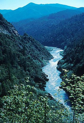
The Klamath River flows 257 miles (414 km) through Oregon and northern California in the United States, emptying into the Pacific Ocean. By average discharge, the Klamath is the second largest river in California after the Sacramento River. It drains an extensive watershed of almost 16,000 square miles (41,000 km2) that stretches from the arid country of south-central Oregon to the temperate rainforest of the Pacific coast. Unlike most rivers, the Klamath begins in the high desert and flows toward the mountains – carving its way through the rugged Cascade Range and Klamath Mountains before reaching the sea. The upper basin, today used for farming and ranching, once contained vast freshwater marshes that provided habitat for abundant wildlife, including millions of migratory birds. Most of the lower basin remains wild, with much of it designated wilderness. The watershed is known for this peculiar geography, and the Klamath has been called "a river upside down" by National Geographic magazine.

Curlew is an unincorporated community and census-designated place (CDP) located in northwestern Ferry County, Washington, United States, between Malo and Danville on State Route 21. The BNSF Railway ran through the town. The historic Ansorge Hotel is located in Curlew. As of the 2010 census, the population of the community was 118. The settlement is named for the curlew birds once prevalent in the area.

The Colville Indian Reservation is an Indian reservation in the northwest United States, in north central Washington, inhabited and managed by the Confederated Tribes of the Colville Reservation, which is federally recognized.

Nooksack Falls is a waterfall along the North Fork of the Nooksack River in Whatcom County, Washington. The water flows through a narrow valley and drops freely 88 feet into a deep rocky river canyon. The falls are viewable from the forested cover near the cliffs edge. The falls are a short 2/3 of a mile drive off the Mount Baker Highway, Washington. The falls were featured in the hunting scene of the movie The Deer Hunter.

The Yuba River is a tributary of the Feather River in the Sierra Nevada and eastern Sacramento Valley, in the U.S. state of California. The main stem of the river is about 40 miles (64 km) long, and its headwaters are split into three major forks. The Yuba River proper is formed at the North Yuba and Middle Yuba rivers' confluence, with the South Yuba joining a short distance downstream. Measured to the head of the North Yuba River, the Yuba River is just over 100 miles (160 km) long.

The Keller Ferry or Clark Ferry, is a ferry crossing on Franklin D. Roosevelt Lake in the US state of Washington. The crossing carries State Route 21 between the Colville Indian Reservation in Ferry County and Clark in Lincoln County. The ferry has been in operation since the 1890s and under state control since 1930. During that time, five vessels have served the crossing, including the Martha S., which operated from 1948 to 2013, and the current ferry, the M/V Sanpoil.
Keller is an unincorporated community and census-designated place (CDP) in southwestern Ferry County in the northeastern part of the U.S. state of Washington. As of the 2010 census, the population was 234.

Keechelus Lake is a lake and reservoir in the northwest United States, near Hyak in Kittitas County, Washington. Approximately fifty miles (80 km) southeast of Seattle and a few miles southeast of Snoqualmie Pass, it is the source of the Yakima River.
The Chelan are an Interior Salish people speaking the Wenatchi dialect, though separate from that tribe. The name derives from the traditional Wenatchi name Tsi-Laan meaning "deep water".

The Kettle River Range, often called the Kettle Range, is the southernmost range of the Monashee Mountains, located in far southeastern British Columbia, Canada and Ferry County, Washington, in the United States. Most of the northern half of the range is protected by the Colville National Forest and the southern half of the range is located on the Colville Indian Reservation. The highest peak is Copper Butte, which reaches 2,177 metres (7,142 ft). The range is crossed by Washington State Route 20 at Sherman Pass.
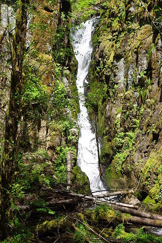
Ki-a-Kuts Falls is a 40-foot (12 m) tall waterfall on the Tualatin River in Washington County, Oregon, United States. Discovered in 1993 in the more remote upper stretch of the river, the falls were named after the last chief of the local band of Native Americans, Chief Ki-a-Kuts of the Atfalati. The water descends in a single fall down a narrow channel in the basalt cliffs overhanging the river at that spot.
Twin Lakes is a census-designated place in Ferry County, Washington, United States.


