
North East England is one of nine official regions of England at the first level of ITL for statistical purposes. The region has three current administrative levels below the region level in the region: combined authority, unitary authority or metropolitan borough, and civil parishes. They are also multiple divisions without administrative functions; ceremonial county, emergency services, built-up areas and historic county. The largest settlements in the region are Newcastle upon Tyne, Middlesbrough, Sunderland, Gateshead, Darlington, Hartlepool and Durham.

Bracknell Forest is a unitary authority area in Berkshire, southern England. It covers the two towns of Bracknell and Sandhurst and the village of Crowthorne and also includes the areas of North Ascot, Binfield, Warfield, and Winkfield. The borough borders Wokingham and the Royal Borough of Windsor & Maidenhead in Berkshire, and also parts of Surrey and Hampshire.

Hart is a local government district in Hampshire, England, named after the River Hart. Its council is based in Fleet. The district also contains the towns of Blackwater and Yateley, along with numerous villages and surrounding rural areas.
Tendring District is a local government district in north-east Essex, England. Its council is based in Clacton-on-Sea, the largest town. Other towns are Brightlingsea, Harwich, Frinton-on-Sea and Walton-on-the-Naze.
GSS codes are nine-character geocodes maintained by the United Kingdom's Office for National Statistics (ONS) to represent a wide range of geographical areas of the UK, for use in tabulating census and other statistical data. GSS refers to the Government Statistical Service of which ONS is part.

Nicholas Jon Barmby is an English football coach and former professional player.
Tottenham Green was an electoral ward within the London Borough of Haringey in Greater London, England from 2002 to 2022.

Fulwood ward—which includes the districts of Fulwood, Lodge Moor, and Ranmoor—is one of the 28 electoral wards in the City of Sheffield, England. It is located in the far western part of the city and covers an area of 23.2 km2. The population of this ward in 2011 was 18,233 people in 6,476 households. Fulwood ward is one of the five wards that make up the Sheffield Hallam Parliamentary constituency. As of June 2022, Andrew Sangar, Sue Alston, and Cliff Woodcraft, all Liberal Democrats, were councillors for the ward. The current Member of Parliament is Labour's Olivia Blake.

Southmead is a northern suburb and council ward of Bristol, in the south west of England, bordered by Filton in South Gloucestershire and Monks Park, Horfield, Henleaze and Westbury on Trym.

Hertsmere is a constituency in Hertfordshire, England, represented in the House of Commons since 2015 by Oliver Dowden, who currently serves as deputy prime minister.

Barrow Island is an area and electoral ward of Barrow-in-Furness, Cumbria, England. Originally separate from the British mainland, land reclamation in the 1860s saw the northern fringes of the island connected to Central Barrow. Barrow Island is also bound to the south and east by the town's dock system and to the west by Walney Channel. The Ward population taken at the 2011 census was 2,616.
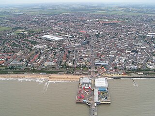
Jaywick is a coastal village in the Tendring district of Essex, England, 2 miles (3 km) west of Clacton-on-Sea. It lies on the North Sea coast of England, 60 miles (97 km) from London and 17 miles (27 km) from Colchester. It was constructed in the 1930s as a holiday resort for Londoners, but has, over time, been officially named the most deprived area in the country.
Thorntree is a housing estate in east Middlesbrough, North Yorkshire, England. The former Thorntree Ward's population was 6,290, at the 2011 census. Since 2015, the estate shares a ward with Brambles Farm.
The Carstairs index is an index of deprivation used in spatial epidemiology to identify Socio-economic confounding.
The Indices of deprivation 2004 is a deprivation index at the small area level, created by the British Department for Communities and Local Government(DCLG).
Southwick is a former village and now a suburb on the north banks of the River Wear in the city of Sunderland in the county of Tyne and Wear, historically in County Durham. From 1894 to 1928, Southwick was administered by the Southwick-on-Wear Urban District Council, before being absorbed by Sunderland.
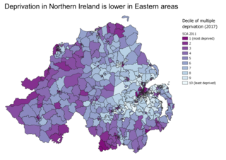
Indices of multiple deprivation (IMD) are widely-used datasets within the UK to classify the relative deprivation of small areas. Multiple components of deprivation are weighted with different strengths and compiled into a single score of deprivation.

Multidimensional Poverty Indices use a range of indicators to calculate a summary poverty figure for a given population, in which a larger figure indicates a higher level of poverty. This figure considers both the proportion of the population that is deemed poor, and the 'breadth' of poverty experienced by these 'poor' households, following the Alkire & Foster 'counting method'. The method was developed following increased criticism of monetary and consumption based poverty measures, seeking to capture the deprivations in non-monetary factors that contribute towards well-being. While there is a standard set of indicators, dimensions, cutoffs and thresholds used for a 'Global MPI', the method is flexible and there are many examples of poverty studies that modify it to best suit their environment. The methodology has been mainly, but not exclusively, applied to developing countries.
The Indices of Deprivation 2010 is a deprivation index at the small area level, created by the British Department for Communities and Local Government (DCLG) and released on 24 March 2011. It follows the ID2007 and because much of the datasets are the same or similar between indices allows a comparison of "relative deprivation" of an area between the two indices.

The Eastern Academic Research Consortium, or "Eastern Arc", is a regional research collaboration between the University of East Anglia, the University of Essex, and the University of Kent. The three partner institutions are all part of the "plate glass universities" established in the 1960s.