
Natural Bridge is a geological formation in Rockbridge County, Virginia, comprising a 215-foot-high (66 m) natural arch with a span of 90 feet (27 m). It is situated within a gorge carved from the surrounding mountainous limestone terrain by Cedar Creek, a small tributary of the James River. Consisting of horizontal limestone strata, Natural Bridge is the remains of the roof of a cave or tunnel through which the Cedar Creek once flowed.

This is a list of properties and historic districts in West Virginia that are listed on the National Register of Historic Places. There are listings in every one of West Virginia's 55 counties.

This is a list of properties and districts in Indiana that are listed on the National Register of Historic Places. There are over 1,900 in total. Of these, 39 are National Historic Landmarks. Each of Indiana's 92 counties has at least two listings.

The Big Rocky Fork Covered Bridge is located 1 mile (1.6 km) southeast of Mansfield, Indiana, on County Road 720 and about 2 miles (3.2 km) east of State Road 59, in Parke County.

The Cogan House Covered Bridge is a Burr arch truss covered bridge over Larrys Creek in Cogan House Township, Lycoming County, in the U.S. state of Pennsylvania. It was built in 1877 and is 94 feet 2 inches (28.7 m) long. The bridge was placed on the National Register of Historic Places in 1980, and had a major restoration in 1998. The Cogan House bridge is named for the township and village of Cogan House, and is also known by at least four other names: Buckhorn, Larrys Creek, Day's, and Plankenhorn.
Indian Creek, is a tributary of the New River, flowing through the state of West Virginia in the United States.

The Locust Creek Covered Bridge is the only remaining covered bridge in Pocahontas County, West Virginia. It is located approximately 6 miles (9.7 km) outside Hillsboro. The bridge is now for pedestrian traffic only.

Staats Mill Covered Bridge, also known as Tug Fork Covered Bridge, is a historic wooden covered bridge near Ripley in Jackson County, West Virginia, United States. Built in 1887, the Staats Mill Covered Bridge originally crossed the Tug Fork of Big Mill Creek and was named for Enoch Staats' water-powered mill.
The Barrackville Covered Bridge spans 145 feet (44 m) in a single span across Buffalo Creek near Barrackville, West Virginia. Built in 1853 by local bridge builder Lemuel Chenoweth, the structure is a modified arched Burr truss, with siding added twenty years after the bridge's construction.

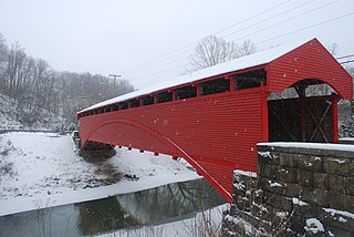
The Fish Creek Covered Bridge was built circa 1881 near Hundred, West Virginia. The kingpost truss bridge spans only 36 feet (11 m). It is the last remaining covered bridge in Wetzel County and one of two remaining single kingpost truss bridges in West Virginia. The bridge has been structurally reinforced with six W8x12 wide-flange steel beams replacing wood stringers. The bridge is enclosed with painted wood siding and a galvanized metal roof. It was listed on the National Register of Historic Places in 1981.
Lowell is an unincorporated community in Summers County, West Virginia, United States. Lowell is located on the Greenbrier River, east of Hinton and southwest of Alderson. The community was first settled in 1770 and is the oldest community in Summers County.

The Alderson Bridge, also known as Alderson Memorial Bridge, is a historic concrete arch bridge in Alderson, West Virginia. It crosses the Greenbrier River, which separates Greenbrier and Monroe counties. The bridge once carried Monroe Street but is now closed to vehicular traffic. It was built in 1914, and measures 21 feet wide including the walkways and 453 feet long.

The Jefferson Avenue–Huron River and Harbin Drive–Silver Creek Canal Bridges are two separate bridges, sharing a continuous railing, that were jointly listed on the National Register of Historic Places on February 10, 2000.

Sarvis Fork Covered Bridge, also known as Sandyville Covered Bridge, is a historic covered bridge located near Sandyville, Jackson County, West Virginia. It was built in 1889-1890 for $64.00 by R.B. Cunningham and G.W. Staats in 1890, originally spanning John Carnahan's Fork, a branch of Mill Creek. When US Route 33 was built using an iron bridge, the covered bridge was first abandoned, then moved and rebuilt over the Left Fork of the Sandy Creek in 1924 for $1,050.00.

Hokes Mill Covered Bridge is a historic covered bridge at Ronceverte, Greenbrier County, West Virginia. It was built over Second Creek between 1897 and 1899, and measures 12 feet wide and 81.6 feet long. It has red board-and-batten siding and a standing seam metal roof. It is one of two remaining covered bridges in Greenbrier County, the other being Herns Mill Covered Bridge.
Bartram's Covered Bridge, a historic covered bridge built in 1860, uses a Burr Truss design and carried Goshen Road over Crum Creek on the border between Delaware County and Chester County, Pennsylvania. It is 30 feet (9.1 m) long and 13 feet (4.0 m) wide and is the only covered bridge remaining of the 30 which once stood in Delaware County. The bridge has slanted planks at each entrance and is the only covered bridge in Pennsylvania with this feature. According to an on-site marker from the Newtown Square Historical Preservation Society, the bridge was built to be "hi and wide as a load of hay" It was built by Ferdinand Wood and named for Mordecai Bartram.

Brig. Gen. John Echols House is a historic home located at Union, Monroe County, West Virginia. It was built between 1845 and 1848, and is a two-story, brick dwelling in the Greek Revival style. The house measures 44 feet, 6 inches, wide and 52 feet long. It features a hipped roof and prominent, exterior side chimneys. Also on the property is a frame, two-story house that appears to have been used for servant's quarters. The house was owned for 20 years by Brig Gen. John Echols (1823–1896), a general in the Confederate States Army during the American Civil War.

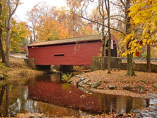
Laurel Creek Covered Bridge is a historic covered bridge located near Lillydale, Monroe County, West Virginia. It was built in 1910. The shortest covered bridge in the state, it measures 34 feet, 6 inches long and 13 feet, 2 1/2 inches wide. It has wood siding painted red and a galvanized metal roof. By 1981, it was one of only 17 covered bridges left in West Virginia.

Howard's Covered Bridge is a historic covered bridge outside of Smithonia, Georgia in Oglethorpe County, Georgia. It was added to the National Register of Historic Places on July 1, 1975. The bridge is located 3 miles southeast of Smithonia on SR S2164. The bridge was built in 1905 in a Town lattice design and is 168 feet long. The span travels over Big Clouds Creek. The site is marked by a historical marker posted by the Georgia Historical Society. The bridge was named for the pioneer family that settled in the area in the late 1700s. It was built with convict labor and is fastened with wooden trunnels. The timber used was transported on the Smithonia and Dunlap Railroad, connecting James Monroe Smith's farm with the Georgia Railroad at Dunlap, Georgia.


