Indianapolis, colloquially known as Indy, is the state capital and most-populous city of the U.S. state of Indiana and the seat of Marion County. According to the United States Census Bureau, the consolidated population of Indianapolis and Marion County in 2020 was 977,203. The "balance" population, which excludes semi-autonomous municipalities in Marion County, was 887,642. It is the 15th most populous city in the U.S., the third-most populous city in the Midwest, after Chicago and Columbus, Ohio, and the fourth-most populous state capital after Phoenix, Arizona; Austin, Texas; and Columbus. The Indianapolis metropolitan area is the 33rd most populous metropolitan statistical area in the U.S., with 2,111,040 residents. Its combined statistical area ranks 28th, with a population of 2,431,361. Indianapolis covers 368 square miles (950 km2), making it the 18th largest city by land area in the U.S.

Corydon is a town in Harrison Township, Harrison County, Indiana. Located north of the Ohio River in the extreme southern part of the U.S. state of Indiana, it is the seat of government for Harrison County. Corydon was founded in 1808 and served as the capital of the Indiana Territory from 1813 to 1816. It was the site of Indiana's first constitutional convention, which was held June 10–29, 1816. Forty-three convened to consider statehood for Indiana and drafted its first state constitution. Under Article XI, Section 11, of the Indiana 1816 constitution, Corydon was designated as the capital of the state until 1825, when the seat of state government was moved to Indianapolis. During the American Civil War, Corydon was the site of the Battle of Corydon, the only official pitched battle waged in Indiana during the war. More recently, the town's numerous historic sites have helped it become a tourist destination. A portion of its downtown area is listed in the National Register of Historic Places as the Corydon Historic District. As of the 2010 census, Corydon had a population of 3,122.

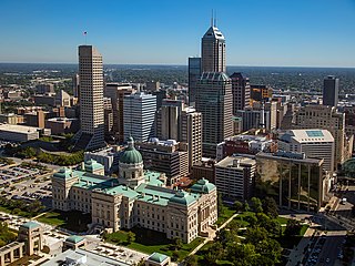
The Indiana Statehouse is the state capitol building of the U.S. state of Indiana. It houses the Indiana General Assembly, the office of the Governor of Indiana, the Indiana Supreme Court, and other state officials. The Statehouse is located in the capital city of Indianapolis at 200 West Washington Street. Built in 1888, it is the fifth building to house the state government.

The Purdue University system is a public university system in the U.S. state of Indiana. A land-grant university with nearly 75,000 students across six traditional campuses comprising five institutions, a statewide technology program, extension centers in each of Indiana's 92 counties, and continuing education programs. Additionally, there are another ~44,000 students enrolled in an online university. Each university in the system maintains its own faculty and admissions policies which are overseen by the Purdue University Board of Trustees. Purdue's main campus in West Lafayette is the best-known, noted for its highly regarded programs in engineering and adjacent subjects.
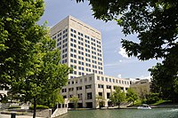
Downtown Indianapolis is a neighborhood area and the central business district of Indianapolis, Indiana, United States. Downtown is bordered by Interstate 65, Interstate 70, and the White River, and is situated near the geographic center of Marion County. Downtown has grown from the original 1821 town plat—often referred to as the Mile Square—to encompass a broader geographic area of central Indianapolis, containing several smaller historic neighborhoods.

The history of Indianapolis spans three centuries. Founded in 1820, the area where the city now stands was originally home to the Lenape. In 1821, a small settlement on the west fork of the White River at the mouth of Fall Creek became the county seat of Marion County, and the state capital of Indiana, effective January 1, 1825. Initially the availability of federal lands for purchase in central Indiana made it attractive to the new settlement; the first European Americans to permanently settle in the area arrived around 1819 or early 1820. In its early years, most of the new arrivals to Indianapolis were Europeans and Americans with European ancestry, but later the city attracted other ethnic groups. The city's growth was encouraged by its geographic location, 2 miles (3.2 km) northwest of the state's geographic center. In addition to its designation as a seat of government, Indianapolis's flat, fertile soil, and central location within Indiana and the Midwest, helped it become an early agricultural center. Its proximity to the White River, which provided power for the town's early mills in the 1820s and 1830s, and the arrival of the railroads, beginning in 1847, established Indianapolis as a manufacturing hub and a transportation center for freight and passenger service. An expanding network of roads, beginning with the early National Road and the Michigan Road, among other routes, connected Indianapolis to other major cities.

The Indiana Convention Center is a major convention center located in Downtown Indianapolis, Indiana, United States. The original structure was completed in 1972 and has undergone five expansions. In total, there are 71 meeting rooms, 11 exhibit halls, and three multi-purpose ballrooms. The connected facilities of Lucas Oil Stadium offer an additional 183,000 square feet (20,000 m2) of exhibit space and 12 meeting rooms.

The Corydon Historic District is a national historic district located in Corydon, Indiana, United States. The town of Corydon is also known as Indiana's First State Capital and as Historic Corydon. The district was added to the National Register of Historic Places in 1973, but the listing was amended in 1988 to expand the district's geographical boundaries and include additional sites. The district includes numerous historical structures, most notably the Old Capitol, the Old Treasury Building, Governor Hendricks' Headquarters, the Constitution Elm Memorial, the Posey House, the Kintner-McGrain House, and The Kintner House Inn, as well as other residential and commercial sites.

The Madam C. J. Walker Building, which houses the Madam Walker Legacy Center, was built in 1927 in the city of Indianapolis, in the U.S. state of Indiana, and as Madam C. J. Walker Manufacturing Company, it was designated a National Historic Landmark in 1991. The four-story, multi-purpose Walker Building was named in honor of Madam C. J. Walker, the African American hair care and beauty products entrepreneur who founded the Madam C. J. Walker Manufacturing Company, and designed by the Indianapolis architectural firm of Rubush & Hunter. The building served as the world headquarters for Walker's company, as well as entertainment, business, and commercial hub along Indiana Avenue for the city's African American community from the 1920s to the 1950s. The historic gathering place and venue for community events and arts and cultural programs were saved from demolition in the 1970s. The restored building, which includes African, Egyptian, and Moorish designs, is one of the few remaining African-Art Deco buildings in the United States. The Walker Building was added to the National Register of Historic Places in 1980.

Indiana Landmarks is America's largest private statewide historic preservation organization. Founded in 1960 as Historic Landmarks Foundation of Indiana by a volunteer group of civic and business leaders led by Indianapolis pharmaceutical executive Eli Lilly, the organization is a private non-governmental organization with nearly 6,000 members and an endowment of over $40-million. The organization simplified its name to Indiana Landmarks in 2010.
The Bates–Hendricks neighborhood is situated just south and east of the downtown commercial district of Indianapolis, Indiana. The Fountain Square business district is just to the east.
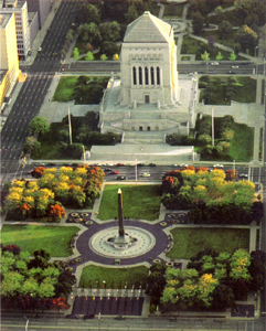
The Indiana World War Memorial Plaza is an urban feature and war memorial located in downtown Indianapolis, Indiana, United States, originally built to honor the veterans of World War I. It was conceived in 1919 as a location for the national headquarters of the American Legion and a memorial to the state's and nation's veterans.

The Indiana Central Canal was a canal intended to connect the Wabash and Erie Canal to the Ohio River. It was funded by the Mammoth Internal Improvement Act, Indiana's attempt to take part in the canal-building craze started by the Erie Canal. $3.5 million was allocated for the project, the largest piece of the entire $10 million Act. However, due to the Panic of 1837, Indiana suffered financial difficulties and had to turn the canal over to the state's creditors, and building of the canal was stopped in 1839. The canal was supposed to extend 296 miles (476 km), from Peru, Indiana, to Evansville, Indiana, where it would reach the Ohio River. It was originally divided into two sections, North and South. Later, a third section was designated, called the Indianapolis section. Only eight miles (13 km) were completed, with an additional 80 miles (130 km) between Anderson, Indiana, and Martinsville, Indiana, having been partially built.

The 220 Meridian, formerly known as the AT&T 220 Building, is a 23-floor high rise located at 220 North Meridian Street in Indianapolis, Indiana. It was completed in 1974 when it served as the headquarters of Indiana Bell.

Here I Grew Up, is a public artwork by American artist Garo Z. Antreasian, located on the lower level of the Indiana Government Center North building, which is near Indianapolis, Indiana, United States. This mosaic depicting five stages of Abraham Lincoln's life in Indiana between the ages of 7 and 21 can be found on the west side of the building by the escalators leading down to the tunnel to Indiana Government Center South. The mosaic is located between the cafeteria's entrance and an automated teller machine.

The Abraham Lincoln commemorative plaque is a work of public art designed by Marie Stewart in 1906, created by Rudolph Schwarz, and dedicated on 12 February 1907.

Marcy Village Apartments is a historic community located in Indianapolis, Indiana, United States. Built in 1939, the 25-acre (10 ha), 19-building apartment community compose a historic district that was listed on the National Register of Historic Places on March 24, 2004. Ground for the development was broken the week of March 20, 1939, and work was started on a full-time basis with Everett A. Carson of Indianapolis as the builder. Architects, Granger & Bollenbacher of Chicago, created the Colonial Revival apartment community for owners at the time, Marcy Realty Corporation.

Mount Pisgah Lutheran Church, also known in its early years as the First Lutheran Church and First English Lutheran Church and more recently as The Sanctuary on Penn, is located at 701 North Pennsylvania Street in downtown Indianapolis, Indiana. The historic church was built by the city's first Lutheran congregation, which organized in 1837, and was its third house of worship. The former church, whose present-day name is The Sanctuary on Penn, is operated as a for-profit event venue.

Beth-El Zedeck Temple, originally known as Beth-El Temple, is a historic synagogue located in the Mapleton-Fall Creek neighborhood in Indianapolis, Indiana, United States. The building was completed in 1924, and was originally home to Congregation Beth-El before merging with the Ohev Zedeck congregation in 1928. It is the oldest remaining synagogue structure in Indianapolis.