
Okaloosa County is located in the northwestern portion of the U.S. state of Florida, extending from the Gulf of Mexico to the Alabama state line. As of the 2020 census, the population was 211,668. Its county seat is Crestview. Okaloosa County is included in the Crestview-Fort Walton Beach-Destin, FL Metropolitan Statistical Area.
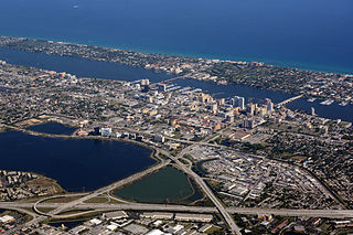
Palm Beach County is a county located in the southeastern part of Florida and lies directly north of Broward County and Miami-Dade County. The county had a population of 1,496,770 as of the 2019 U.S. Census, making it the third-most populous county in the state of Florida and the 25th-most populous county in the United States. The largest city and county seat is West Palm Beach. Named after one of its oldest settlements, Palm Beach, the county was established in 1909, after being split from Dade County. The county's modern-day boundaries were established in 1963.

Walton County is located on the Emerald Coast in the northwestern part of the U.S. state of Florida, with its southern border on the Gulf of Mexico. As of the 2020 census, the population was 75,305. Its county seat is DeFuniak Springs. The county is home to the highest natural point in Florida: Britton Hill, at 345 feet (105 m). Walton County is included in the Crestview-Fort Walton Beach-Destin, FL Metropolitan Statistical Area.
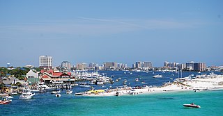
Destin is a city located in Okaloosa County, Florida. It is a principal city of the Crestview–Fort Walton Beach–Destin, Florida, metropolitan area.

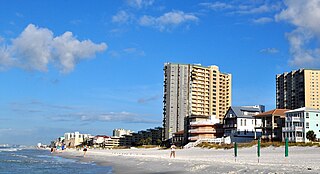
Fort Walton Beach is a city in southern Okaloosa County, Florida, United States. As of the 2020 U.S. census, the population was 20,922, up from 19,507 in 2010. It is the principal city of the Fort Walton Beach−Crestview−Destin Metropolitan Statistical Area.
Shalimar is a town in Okaloosa County, Florida, United States. The population was 717 at the 2010 census. It is part of the Fort Walton Beach–Crestview–Destin Metropolitan Statistical Area.
Miramar Beach is a census-designated place (CDP) in Walton County, Florida, United States. The population was 6,146 at the 2010 census. Although many other coastal localities in Florida have appended "Beach" to their names to distinguish themselves from an adjacent inland or cross-bay municipality – such as Miami Beach, St. Pete Beach, Fort Myers Beach, Panama City Beach, Melbourne Beach, Cocoa Beach, and Jacksonville Beach – the city of Miramar, Florida is actually over 450 miles (720 km) away in South Florida. Miramar Beach is due east of Destin, Florida. It is often considered to be part of the city of Destin. However, it has its own ZIP code (32550) and is in Walton County, whereas Destin is in Okaloosa County.

The Florida Panhandle is the northwestern part of the U.S. state of Florida; it is a strip of land roughly 200 miles (320 km) long and 50 to 100 miles wide, lying between Alabama on the north and the west, Georgia on the north, and the Gulf of Mexico to the south. Its eastern boundary is arbitrarily defined. In terms of population, major communities include Tallahassee, Pensacola, and Panama City.
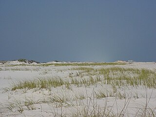
Santa Rosa Island is a 40-mile (64 km) barrier island located in the U.S. state of Florida, thirty miles (50 km) east of the Alabama state border. The communities of Pensacola Beach, Navarre Beach, and Okaloosa Island are located on the island. On the northern side of the island, are Pensacola Bay on the west and Choctawhatchee Bay on the east, joined through Santa Rosa Sound.

The Emerald Coast is an unofficial name for the coastal area in the US state of Florida on the Gulf of Mexico that stretches about 100 miles (160 km) through five counties, Escambia, Santa Rosa, Okaloosa, Walton, and Bay, which include Pensacola Beach, Navarre Beach, Fort Walton Beach, Destin, and Panama City Beach. Some south Alabama communities on the coast of Baldwin County, such as Gulf Shores, Orange Beach, and Fort Morgan embrace the term as well.

Navarre is a census-designated place and unincorporated community in Santa Rosa County in the northwest Florida Panhandle. It is a major bedroom community for mostly U.S. military personnel, federal civil servants, local population, retirees and defense contractors. Due to Navarre Beach and the 4 miles (6.4 km) of beach front on the Gulf of Mexico thereof, as well as several miles of beaches within the Navarre Beach Marine Park and the Gulf Islands National Seashore, it has a small, but rapidly growing community of nature enthusiasts and tourists. Navarre has grown from being a small town of around 1,500 in 1970 to a town with a population estimated at 41,940 as of 2020, if including both the Navarre and Navarre Beach Census Designated Places.

Florida's 1st congressional district is a congressional district in the U.S. state of Florida, covering the state's western Panhandle. It includes all of Escambia, Okaloosa, Santa Rosa, and Walton counties and portions of Holmes county. The district is anchored in Pensacola and also includes the large military bedroom communities and tourist destinations of Navarre and Fort Walton Beach and stretches along the Emerald Coast. The district is currently represented by Republican Matt Gaetz. With a Cook Partisan Voting Index rating of R+20, it is one of the most Republican districts in Florida.

The Houses of Refuge in Florida were a series of stations operated by the United States Life Saving Service along the coast of Florida to rescue and shelter ship-wrecked sailors. Five houses were constructed on the east coast in 1876, with five more added in 1885 and 1886. There were also two life-saving stations built, one just south of the Jupiter Inlet, the other on the Gulf coast on Santa Rosa Island near Pensacola, Florida. A house of refuge was planned for the Marquesas Keys, but was never put into commission. The houses were manned by civilian contractors who lived in the houses with their families. Most of these houses remained in service as life-saving stations until 1915 or later. Some of the locations became United States Coast Guard stations after the Life-Saving Service was merged with the United States Revenue Cutter Service to form the Coast Guard in 1915.
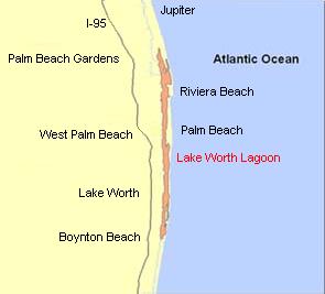
The Lake Worth Lagoon is a lagoon located in Palm Beach County, Florida. It runs parallel to the coast, and is separated from the Atlantic Ocean by barrier beaches, including Palm Beach Island. The lagoon is connected to the Atlantic Ocean by two permanent, man-made inlets.
Santa Rosa Sound is a sound connecting Pensacola Bay and Choctawhatchee Bay in Florida. The northern shore consists of the Fairpoint Peninsula and portions of the mainland in Santa Rosa County and Okaloosa County. It is bounded to the south by Santa Rosa Island, separating it from the Gulf of Mexico.
Grayton Beach is a small, historic beach village on the Florida Panhandle Gulf coast halfway between Destin and Panama City in Walton County and adjacent to Grayton Beach State Park. Collectively, the area is known as the “Beaches of South Walton,” with South Walton referring to the southern portion of Walton County below the Choctawhatchee Bay.
Haulover Park is a 177-acre (72 ha) urban park owned and operated by Miami-Dade County Parks, Recreation & Open Spaces Department, located in metropolitan Miami, just north of Bal Harbour, Florida. The park is located on a shoal between the Atlantic Ocean and Biscayne Bay, just north of the Broad Causeway and Collins Avenue.

Choctawhatchee Bay is a bay in the Emerald Coast region of the Florida Panhandle. The bay, located within Okaloosa and Walton counties, has a surface area of 334 square kilometres (129 sq mi). It is an inlet of the Gulf of Mexico, connected to it through East Pass. It also connects to Santa Rosa Sound in Fort Walton Beach, Florida to the west and to St. Andrews Bay in Bay County to the east, via the Gulf Intracoastal Waterway. East Pass is the only outlet of the bay flowing directly into the Gulf of Mexico. The Choctawhatchee River flows into Choctawhatchee Bay, as do several smaller rivers and streams. The Mid-Bay Bridge crosses the bay, connecting the city of Destin to Niceville, Florida.
The South Lake Worth Inlet, also known as the Boynton Inlet, is an artificial cut through a barrier beach connecting the south end of the Lake Worth Lagoon in Palm Beach County, Florida with the Atlantic Ocean. The inlet is 130 feet (40 m) wide and 6 to 12 feet deep.
Seagrove Beach, Florida is a two-mile-long beach community located on the Florida Panhandle, on the Gulf of Mexico, in Walton County, Florida. Seagrove Beach has Florida's highest 1 Mile of continuous Beach along the Miracle Mile extending East from Seaside for 1 Mile. It is located along County Highway 30a, east of Seaside, Florida and west of WaterSound Beach. Seagrove Beach is recognized locally as an independent neighborhood, however its official mailing address is Santa Rosa Beach, Florida. Like the other communities along 30a and Florida's Emerald Coast in general, Seagrove Beach is known for its scenic and appealing "sugar white" beaches and blue/green waters. There are 20 public beach accesses available for use in Seagrove. Tourism website "Visitsouthwalton.com" describes Seagrove Beach as "laid back, but luxurious" and home to upscale boutiques, casual cafes, a state park and rare coastal dune lakes.
