
Fort William is a town in Lochaber in the Scottish Highlands, located on the eastern shore of Loch Linnhe. At the 2011 census, Fort William had a population of 10,459, making it the second largest settlement in both the Highland council area, and the whole of the Scottish Highlands; only the city of Inverness has a larger population.
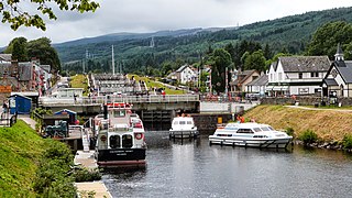
Fort Augustus is a settlement in the parish of Boleskine and Abertarff, at the south-west end of Loch Ness, Scottish Highlands. The village has a population of around 646 (2001). Its economy is heavily reliant on tourism.
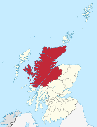
Highland is a council area in the Scottish Highlands and is the largest local government area in the United Kingdom. It was the 7th most populous council area in Scotland at the 2011 census. It shares borders with the council areas of Aberdeenshire, Argyll and Bute, Moray and Perth and Kinross. Their councils, and those of Angus and Stirling, also have areas of the Scottish Highlands within their administrative boundaries.
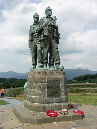
The A82 is a major road in Scotland that runs from Glasgow to Inverness via Fort William. It is one of the principal north-south routes in Scotland and is mostly a trunk road managed by Transport Scotland, who view it as an important link from the Central Belt to the Scottish Highlands and beyond. The road passes close to numerous landmarks, including Loch Lomond, Rannoch Moor, Glen Coe, the Ballachulish Bridge, Ben Nevis, the Commando Memorial, Loch Ness, and Urquhart Castle. Along with the A9 and the A90 it is one of the three major north–south trunk roads connecting the Central Belt to the North.

The Great Glen, also known as Glen Albyn or Glen More, is a glen in Scotland running for 62 miles (100 km) from Inverness on the edge of the Moray Firth, in an approximately straight line to Fort William at the head of Loch Linnhe. It follows a geological fault known as the Great Glen Fault, and bisects the Scottish Highlands into the Grampian Mountains to the southeast and the Northwest Highlands to the northwest.

Kyle of Lochalsh is a village in the historic county of Ross & Cromarty on the northwest coast of Scotland, located around 55 miles (90 km) west-southwest of Inverness. It is located on the Lochalsh peninsula, at the entrance to Loch Alsh, opposite the village of Kyleakin on the Isle of Skye. A ferry used to connect the two villages until it was replaced by the Skye Bridge, about a mile (2 km) to the west, in 1995.

Dunvegan is a village on the Isle of Skye in Scotland. It is famous for Dunvegan Castle, seat of the chiefs of Clan MacLeod. Dunvegan is within the parish of Duirinish, and Duirinish Parish Church is at Dunvegan. In 2011 it had a population of 386.

Lairg is a village and parish in Sutherland, Scotland. It has a population of 891 and is at the south-eastern end of Loch Shin.
Glenelg is a scattered community area and civil parish in the Lochalsh area of Highland in western Scotland. Despite the local government reorganisation the area is considered by many still to be in Inverness-shire, the boundary with Ross-shire being at the top of Mam Ratagan the single-track road entry into Glenelg.

Drumnadrochit is a village in the Highland local government council area of Scotland, lying near the west shore of Loch Ness at the foot of Glen Urquhart. The village is close to several neighbouring settlements: the villages of Milton to the west, Kilmore to the east and Lewiston to the south. The villages act as a centre for regional tourism beside Loch Ness, as well as being a local economic hub for the nearby communities.

Comrie is a village and parish in the southern Highlands of Scotland, towards the western end of the Strathearn district of Perth and Kinross, 7 mi (11 km) west of Crieff.

Achlain is a house in Glenmoriston in the Highland council area of Scotland. It is about 15 km west of Invermoriston, next to the A887 road and the River Moriston.

Spean Bridge railway station is a railway station serving the village of Spean Bridge in the Highland region of Scotland. This station is on the West Highland Line, between Roy Bridge and Fort William, sited 90 miles 56 chains (146 km) from Craigendoran Junction, near Helensburgh. ScotRail manage the station and operate most services, along with Caledonian Sleeper.
Newcraighall is a South-Eastern suburb of Edinburgh, Scotland. A former mining village, its prosperity was based on the Midlothian coalfields. The Newcraighall pit was known as 'Klondyke' and closed in the 1960s, work transferring to nearby Bilston Glen and in particular the last-to-close (1998) Monktonhall pit. The village had a church, a Co-op and a miners' club and bowling green. Newcraighall now plays host to an out-of-town shopping complex, Fort Kinnaird, previously known as ‘’Edinburgh Fort and Kinnaird Park (north). Today, the retail park is still commonly referred to as "The Fort" by residents.

The Great Glen Way is a long distance path in Scotland. It follows the Great Glen, running from Fort William in the southwest to Inverness in the northeast, covering 125 kilometres (78 mi). It was opened in 2002, and is designated as one of Scotland's Great Trails by NatureScot. The Great Glen Way is generally walked from southwest to northeast to follow the direction of the prevailing wind. It can be walked in 5–7 days, or cycled in 2–3 days. The trail is maintained and improved by the Great Glen Ways partnership, which consists of Highland Council, Scottish Canals and Forestry and Land Scotland. About 30,000 people use the path every year, of whom about 4,500 complete the entire route.

Taynuilt is a large village in Argyll and Bute, Scotland located at the western entrance to the narrow Pass of Brander.
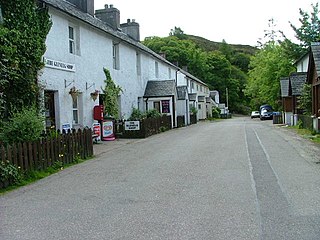
Spean Bridge is a village in the parish of Kilmonivaig, in Lochaber in the Highland region of Scotland.

Glenmoriston or Glen Moriston is a river glen in the Scottish Highlands, that runs from Loch Ness, at the village of Invermoriston, westwards to Loch Cluanie, where it meets with Glen Shiel. The A887 and A87 roads pass through Glenmoriston.

Ardelve is a village in Highland, Scotland, on Loch Alsh. It overlooks the Eilean Donan Castle, which is in Dornie, also on Loch Alsh, to the east of Skye. A caravan park, several guest houses, a bakery, and pizzeria are located within Ardelve.
The River Moriston is a river in Inverness-shire, Scotland. It flows broadly east-north-east from the outfall of the dam at Loch Cluanie to Loch Ness. Its waters and those of its tributaries have been harnessed to generate hydro-electric power.


