Related Research Articles
Franklin Park is a census-designated place (CDP) in Broward County, Florida, United States. The population was 860 at the 2010 census.

The International Latitude Service was created by the International Geodetic Association in 1899 to study variations in latitude caused by polar motion, precession, or "wobble" of the Earth's axis.

Saskatoon Fairview is a provincial electoral district for the Legislative Assembly of Saskatchewan, Canada. The district includes the neighbourhoods of Kensington, Parkridge, Pacific Heights, Blairmore S. C., Confederation Park and part of Massey Place. Contrary to the name, the neighbourhood of Fairhaven is not part of the riding.

The Houses of Refuge in Florida were a series of stations operated by the United States Life Saving Service along the coast of Florida to rescue and shelter ship-wrecked sailors. Five houses were constructed on the east coast in 1876, with five more added in 1885 and 1886. There were also two life-saving stations built, one just south of the Jupiter Inlet, the other on the Gulf coast on Santa Rosa Island near Pensacola, Florida. A house of refuge was planned for the Marquesas Keys, but was never put into commission. The houses were manned by civilian contractors who lived in the houses with their families. Most of these houses remained in service as life-saving stations until 1915 or later. Some of the locations became United States Coast Guard stations after the Life-Saving Service was merged with the United States Revenue Cutter Service to form the Coast Guard in 1915.
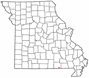
Myrtle is a small, unincorporated community in Oregon County, Missouri, United States. It lies 14 mi (23 km) southeast of Alton, 14 mi (23 km) east of Thayer and approximately 3⁄4 mi (1.2 km) north of the Arkansas state line. The community lies on a low ridge above the south side of Mill Creek along Missouri Route V.
Brownsboro-Zorn is a neighborhood in northeast Louisville, Kentucky, United States. Its boundaries are Brownsboro Road to the south, Birchwood Avenue to the west, Mellwood Avenue to the north, and Mockingbird Valley to the east. Residential development began in 1911 between Birchwood and Zorn Avenue, a wide street which bisects the neighborhood. The core of the neighborhood is residential, but there is substantial commerce along Brownsboro Road. The Veterans Affairs Medical Center is located along Zorn.
Butaw District (Buto) is one of 16 districts of Sinoe County, Liberia. As of 2008, the population was 3,892.
Read Island Provincial Park is a provincial park in British Columbia, Canada. It is located on the south end of Read Island. Established in 1996, the park contains approximately 637 ha.

Zuber is an unincorporated community in Marion County, Florida, United States. It is located near the intersection of State Road 326 and County Road 25A. Its commerce is supported by its proximity to Interstate 75.
The Stone First Nation or Yunesitʼin First Nation is a band government of the Yunesit'in subgroup of the Tsilhqot'in people, whose territory is the Chilcotin District in the western Central Interior region of the Canadian province of British Columbia. It is a member of the Tsilhqot'in Tribal Council. The people of the Stone First Nation are known as the Yunesit'in in the Chilcotin language.

Guaitarilla is a town and municipality in the Nariño Department, Colombia.

San Vicente de Alcántara is a municipality in the province of Badajoz, Extremadura, Spain. It has a population of 5,788 and an area of 275 km².

Mallard is an abandoned townsite in sections 5 and 8 of Itasca Township in Clearwater County, Minnesota, United States. The nearest community is Alida, Minnesota, to the north.
Pierceville is an unincorporated community in Franklin Township, Ripley County, in the U.S. state of Indiana.
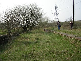
Staveley Works railway station was on the outskirts of the town of Staveley, Derbyshire.
Tyoax Pass is a mountain pass in the Chilcotin Ranges of the Pacific Ranges, the southernmost main subdivision of the Coast Mountains of British Columbia, Canada. Located at the head of Tyaughton Creek, a north tributary of the Bridge River, it connects the basin of the Bridge River with that of Big Creek in the southern Chilcotin District, and is therefore at the boundary between the Spruce Lake Protected Area and Big Creek Provincial Park.

Sestrimo Glacier is the 11 km long and 4 km wide glacier on the northwest side of Trinity Peninsula in Graham Land on the Antarctic Peninsula. Situated southwest of Ogoya Glacier, west-northwest of Broad Valley and north of Cugnot Ice Piedmont. Draining the north slopes of Windy Gap, and flowing northwards east of Mount D'Urville and west of Argentino (Guerrero) Peak to enter Lafond Bay in Bransfield Strait south of Cockerell Peninsula.

Bolgrad Glacier is the 7.4 km long and 5.7 km wide glacier on the west side of Owen Ridge in southern Sentinel Range in Ellsworth Mountains, Antarctica, situated south of Brook Glacier and north of Sirma Glacier. It drains west-southwestwards from Mount Allen, Mount Liptak and Mount Southwick, and flows south of Krusha Peak to leave the range and join Bender Glacier east of Gilbert Spur.
Virginia is an unincorporated community in Bates County, in the U.S. state of Missouri.
References
Municipalities and communities of Calhoun County, Florida, United States | ||
|---|---|---|
| City |  | |
| Town | ||
| Unincorporated communities | ||
Coordinates: 30°16′01″N85°8′0″W / 30.26694°N 85.13333°W