A world file is a six line plain text sidecar file used by geographic information systems (GIS) to georeference raster map images. The file specification was introduced by Esri, and consists of six coefficients of an affine transformation that describes the location, scale and rotation of a raster on a map

A projected coordinate system – also called a projected coordinate reference system, planar coordinate system, or grid reference system – is a type of spatial reference system that represents locations on Earth using Cartesian coordinates (x, y) on a planar surface created by a particular map projection. Each projected coordinate system, such as "Universal Transverse Mercator WGS 84 Zone 26N," is defined by a choice of map projection (with specific parameters), a choice of geodetic datum to bind the coordinate system to real locations on the earth, an origin point, and a choice of unit of measure. Hundreds of projected coordinate systems have been specified for various purposes in various regions.
The Ordnance Survey National Grid reference system (OSGB) is a system of geographic grid references used in Great Britain, distinct from latitude and longitude.

The transverse Mercator map projection is an adaptation of the standard Mercator projection. The transverse version is widely used in national and international mapping systems around the world, including the Universal Transverse Mercator. When paired with a suitable geodetic datum, the transverse Mercator delivers high accuracy in zones less than a few degrees in east-west extent.
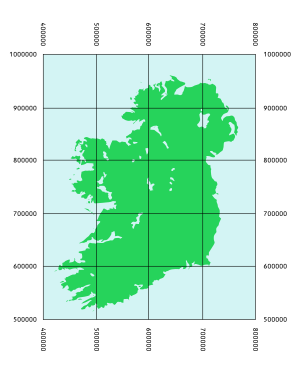
The Irish grid reference system is a system of geographic grid references used for paper mapping in Ireland. The Irish grid partially overlaps the British grid, and uses a similar co-ordinate system but with a meridian more suited to its westerly location.
The Military Grid Reference System (MGRS) is the geocoordinate standard used by NATO militaries for locating points on Earth. The MGRS is derived from the Universal Transverse Mercator (UTM) grid system and the Universal Polar Stereographic (UPS) grid system, but uses a different labeling convention. The MGRS is used as geocode for the entire Earth.
The Swiss coordinate system is a geographic coordinate system used in Switzerland and Liechtenstein for maps and surveying by the Swiss Federal Office of Topography (Swisstopo).

Ordnance Survey Ireland was the national mapping agency of Ireland. It was established on 4 March 2002 as a body corporate. It was the successor to the former Ordnance Survey of Ireland. It and the Ordnance Survey of Northern Ireland (OSNI) were themselves the successors to the Irish operations of the British Ordnance Survey. OSI was part of the Irish public service. OSI was headquartered at Mountjoy House in the Phoenix Park in Dublin, which had previously been the headquarters of the British Ordnance Survey in Ireland until 1922.
Ordnance Survey of Northern Ireland (OSNI) is the official mapping agency of Northern Ireland. The agency ceased to exist separately on 1 April 2008 when it became part of Land and Property Services, an executive agency of the Northern Ireland Department of Finance and Personnel, along with the Rate Collection Agency, the Valuation and Lands Agency, and the Land Registry.
The Universal Transverse Mercator (UTM) is a map projection system for assigning coordinates to locations on the surface of the Earth. Like the traditional method of latitude and longitude, it is a horizontal position representation, which means it ignores altitude and treats the earth surface as a perfect ellipsoid. However, it differs from global latitude/longitude in that it divides earth into 60 zones and projects each to the plane as a basis for its coordinates. Specifying a location means specifying the zone and the x, y coordinate in that plane. The projection from spheroid to a UTM zone is some parameterization of the transverse Mercator projection. The parameters vary by nation or region or mapping system.

The universal polar stereographic (UPS) coordinate system is used in conjunction with the universal transverse Mercator (UTM) coordinate system to locate positions on the surface of the earth. Like the UTM coordinate system, the UPS coordinate system uses a metric-based cartesian grid laid out on a conformally projected surface. UPS covers the Earth's polar regions, specifically the areas north of 84°N and south of 80°S, which are not covered by the UTM grids, plus an additional 30 minutes of latitude extending into UTM grid to provide some overlap between the two systems.
A spatial reference system (SRS) or coordinate reference system (CRS) is a framework used to precisely measure locations on the surface of Earth as coordinates. It is thus the application of the abstract mathematics of coordinate systems and analytic geometry to geographic space. A particular SRS specification comprises a choice of Earth ellipsoid, horizontal datum, map projection, origin point, and unit of measure. Thousands of coordinate systems have been specified for use around the world or in specific regions and for various purposes, necessitating transformations between different SRS.
The United States National Grid (USNG) is a multi-purpose location system of grid references used in the United States. It provides a nationally consistent "language of location", optimized for local applications, in a compact, user friendly format. It is similar in design to the national grid reference systems used in other countries. The USNG was adopted as a national standard by the Federal Geographic Data Committee (FGDC) of the US Government in 2001.
Jordan Transverse Mercator (JTM) (Arabic: نظام تربيع ميركاتور الأردني المستعرض) is a grid system created by the Royal Jordan Geographic Center (RJGC). This system is based on 6° belts with a Central Meridian of 37° East and a Scale Factor at Origin (mo) = 0.9998. The JTM is based on the Hayford ellipsoid adopted by the IUGG in 1924. No transformation parameters are presently offered by the government. However, Prof. Stephen H. Savage of Arizona State University provides the following parameters for the projection:

Israeli Transverse Mercator (ITM), also known as the New Israel Grid is the new geographic coordinate system for Israel. The name is derived from the transverse Mercator projection it uses and the fact that it is optimized for Israel. ITM has replaced the old coordinate system Israeli Cassini Soldner (ICS), also known as the Old Israel Grid (OIG). It became the official grid for Israel in 1998.
Israeli Cassini Soldner (ICS), commonly known as the Old Israeli Grid is the old geographic coordinate system for Israel. The name is derived from the Cassini Soldner projection it uses and the fact that it is optimized for Israel. ICS has been mostly replaced by the new coordinate system Israeli Transverse Mercator (ITM), also known as the New Israeli Grid (NIG), but still referenced by older books and navigation software.
The Bermuda National Grid 2000 (BNG) is a kind of Transverse Mercator projection. It is not a Universal Transverse Mercator (UTM) projection, as it has an origin and other parameters that are different from those used in UTM.
Transverse Mercator projection has many implementations. Louis Krüger in 1912 developed one of his two implementations that expressed as a power series in the longitude difference from the central meridian. These series were recalculated by Lee in 1946, by Redfearn in 1948, and by Thomas in 1952. They are often referred to as the Redfearn series, or the Thomas series. This implementation is of great importance since it is widely used in the U.S. State Plane Coordinate System, in national and also international mapping systems, including the Universal Transverse Mercator coordinate system (UTM). They are also incorporated into the Geotrans coordinate converter made available by the United States National Geospatial-Intelligence Agency. When paired with a suitable geodetic datum, the series deliver high accuracy in zones less than a few degrees in east-west extent.
The Geographical Centre of Ireland, according to an investigation and calculation carried out by the Official Irish Government Mapping Agency, Ordnance Survey Ireland (OSI) published on the official OSI website on 24 February 2022 is near the village of Castletown Geoghegan, County Westmeath.

The Palestine grid was the geographic coordinate system used by the Survey Department of Palestine.