Geodynamics

Last updated

Geodynamics is a subfield of geophysics dealing with dynamics of the Earth. It applies physics, chemistry and mathematics to the understanding of how mantle convection leads to plate tectonics and geologic phenomena such as seafloor spreading, mountain building, volcanoes, earthquakes, faulting. It also attempts to probe the internal activity by measuring magnetic fields, gravity, and seismic waves, as well as the mineralogy of rocks and their isotopic composition. Methods of geodynamics are also applied to exploration of other planets. [1]

Contents

Overview

Geodynamics is generally concerned with processes that move materials throughout the Earth. In the Earth's interior, movement happens when rocks melt or deform and flow in response to a stress field. [2] This deformation may be brittle, elastic, or plastic, depending on the magnitude of the stress and the material's physical properties, especially the stress relaxation time scale. Rocks are structurally and compositionally heterogeneous and are subjected to variable stresses, so it is common to see different types of deformation in close spatial and temporal proximity. [3] When working with geological timescales and lengths, it is convenient to use the continuous medium approximation and equilibrium stress fields to consider the average response to average stress. [4]

Experts in geodynamics commonly use data from geodetic GPS, InSAR, and seismology, along with numerical models, to study the evolution of the Earth's lithosphere, mantle and core.

Work performed by geodynamicists may include:

Deformation of rocks

Rocks and other geological materials experience strain according to three distinct modes, elastic, plastic, and brittle depending on the properties of the material and the magnitude of the stress field. Stress is defined as the average force per unit area exerted on each part of the rock. Pressure is the part of stress that changes the volume of a solid; shear stress changes the shape. If there is no shear, the fluid is in hydrostatic equilibrium. Since, over long periods, rocks readily deform under pressure, the Earth is in hydrostatic equilibrium to a good approximation. The pressure on rock depends only on the weight of the rock above, and this depends on gravity and the density of the rock. In a body like the Moon, the density is almost constant, so a pressure profile is readily calculated. In the Earth, the compression of rocks with depth is significant, and an equation of state is needed to calculate changes in density of rock even when it is of uniform composition. [5]

Elastic

Elastic deformation is always reversible, which means that if the stress field associated with elastic deformation is removed, the material will return to its previous state. Materials only behave elastically when the relative arrangement along the axis being considered of material components (e.g. atoms or crystals) remains unchanged. This means that the magnitude of the stress cannot exceed the yield strength of a material, and the time scale of the stress cannot approach the relaxation time of the material. If stress exceeds the yield strength of a material, bonds begin to break (and reform), which can lead to ductile or brittle deformation. [6]

Ductile

Ductile or plastic deformation happens when the temperature of a system is high enough so that a significant fraction of the material microstates (figure 1) are unbound, which means that a large fraction of the chemical bonds are in the process of being broken and reformed. During ductile deformation, this process of atomic rearrangement redistributes stress and strain towards equilibrium faster than they can accumulate. [6] Examples include bending of the lithosphere under volcanic islands or sedimentary basins, and bending at oceanic trenches. [5] Ductile deformation happens when transport processes such as diffusion and advection that rely on chemical bonds to be broken and reformed redistribute strain about as fast as it accumulates.

Brittle

When strain localizes faster than these relaxation processes can redistribute it, brittle deformation occurs. The mechanism for brittle deformation involves a positive feedback between the accumulation or propagation of defects especially those produced by strain in areas of high strain, and the localization of strain along these dislocations and fractures. In other words, any fracture, however small, tends to focus strain at its leading edge, which causes the fracture to extend. [6]

In general, the mode of deformation is controlled not only by the amount of stress, but also by the distribution of strain and strain associated features. Whichever mode of deformation ultimately occurs is the result of a competition between processes that tend to localize strain, such as fracture propagation, and relaxational processes, such as annealing, that tend to delocalize strain.

Deformation structures

Structural geologists study the results of deformation, using observations of rock, especially the mode and geometry of deformation to reconstruct the stress field that affected the rock over time. Structural geology is an important complement to geodynamics because it provides the most direct source of data about the movements of the Earth. Different modes of deformation result in distinct geological structures, e.g. brittle fracture in rocks or ductile folding.

Thermodynamics

The physical characteristics of rocks that control the rate and mode of strain, such as yield strength or viscosity, depend on the thermodynamic state of the rock and composition. The most important thermodynamic variables in this case are temperature and pressure. Both of these increase with depth, so to a first approximation the mode of deformation can be understood in terms of depth. Within the upper lithosphere, brittle deformation is common because under low pressure rocks have relatively low brittle strength, while at the same time low temperature reduces the likelihood of ductile flow. After the brittle-ductile transition zone, ductile deformation becomes dominant. [2] Elastic deformation happens when the time scale of stress is shorter than the relaxation time for the material. Seismic waves are a common example of this type of deformation. At temperatures high enough to melt rocks, the ductile shear strength approaches zero, which is why shear mode elastic deformation (S-Waves) will not propagate through melts. [7]

Forces

The main motive force behind stress in the Earth is provided by thermal energy from radioisotope decay, friction, and residual heat. [8] [9] Cooling at the surface and heat production within the Earth create a metastable thermal gradient from the hot core to the relatively cool lithosphere. [10] This thermal energy is converted into mechanical energy by thermal expansion. Deeper and hotter rocks often have higher thermal expansion and lower density relative to overlying rocks. Conversely, rock that is cooled at the surface can become less buoyant than the rock below it. Eventually this can lead to a Rayleigh-Taylor instability (Figure 2), or interpenetration of rock on different sides of the buoyancy contrast. [2] [11]

Figure 2 shows a Rayleigh-Taylor instability in 2D using the Shan-Chen model. The red fluid is initially located in a layer on top of the blue fluid, and is less buoyant than the blue fluid. After some time, a Rayleigh-Taylor instability occurs, and the red fluid penetrates the blue one. Model of the initiation of termination of a Rayleigh-Taylor instability in 2D.gif
Figure 2 shows a Rayleigh-Taylor instability in 2D using the Shan-Chen model. The red fluid is initially located in a layer on top of the blue fluid, and is less buoyant than the blue fluid. After some time, a Rayleigh-Taylor instability occurs, and the red fluid penetrates the blue one.

Negative thermal buoyancy of the oceanic plates is the primary cause of subduction and plate tectonics, [12] while positive thermal buoyancy may lead to mantle plumes, which could explain intraplate volcanism. [13] The relative importance of heat production vs. heat loss for buoyant convection throughout the whole Earth remains uncertain and understanding the details of buoyant convection is a key focus of geodynamics. [2]

Methods

Geodynamics is a broad field which combines observations from many different types of geological study into a broad picture of the dynamics of Earth. Close to the surface of the Earth, data includes field observations, geodesy, radiometric dating, petrology, mineralogy, drilling boreholes and remote sensing techniques. However, beyond a few kilometers depth, most of these kinds of observations become impractical. Geologists studying the geodynamics of the mantle and core must rely entirely on remote sensing, especially seismology, and experimentally recreating the conditions found in the Earth in high pressure high temperature experiments.(see also Adams–Williamson equation).

Numerical modeling

Because of the complexity of geological systems, computer modeling is used to test theoretical predictions about geodynamics using data from these sources.

There are two main ways of geodynamic numerical modeling. [14]

  1. Modelling to reproduce a specific observation: This approach aims to answer what causes a specific state of a particular system.
  2. Modelling to produce basic fluid dynamics: This approach aims to answer how a specific system works in general.

Basic fluid dynamics modelling can further be subdivided into instantaneous studies, which aim to reproduce the instantaneous flow in a system due to a given buoyancy distribution, and time-dependent studies, which either aim to reproduce a possible evolution of a given initial condition over time or a statistical (quasi) steady-state of a given system.

See also

Related Research Articles

<span class="mw-page-title-main">Structural geology</span> Science of the description and interpretation of deformation in the Earths crust

Structural geology is the study of the three-dimensional distribution of rock units with respect to their deformational histories. The primary goal of structural geology is to use measurements of present-day rock geometries to uncover information about the history of deformation (strain) in the rocks, and ultimately, to understand the stress field that resulted in the observed strain and geometries. This understanding of the dynamics of the stress field can be linked to important events in the geologic past; a common goal is to understand the structural evolution of a particular area with respect to regionally widespread patterns of rock deformation due to plate tectonics.

<span class="mw-page-title-main">Lithosphere</span> Outermost shell of a terrestrial-type planet or natural satellite

A lithosphere is the rigid, outermost rocky shell of a terrestrial planet or natural satellite. On Earth, it is composed of the crust and the lithospheric mantle, the topmost portion of the upper mantle that behaves elastically on time scales of up to thousands of years or more. The crust and upper mantle are distinguished on the basis of chemistry and mineralogy.

<span class="mw-page-title-main">Asthenosphere</span> Highly viscous, mechanically weak, and ductile region of Earths mantle

The asthenosphere is the mechanically weak and ductile region of the upper mantle of Earth. It lies below the lithosphere, at a depth between ~80 and 200 km below the surface, and extends as deep as 700 km (430 mi). However, the lower boundary of the asthenosphere is not well defined.

<span class="mw-page-title-main">Earth's mantle</span> A layer of silicate rock between Earths crust and its outer core

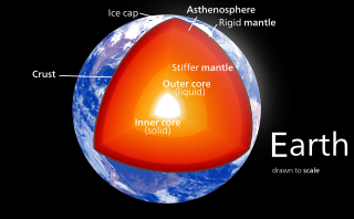
Earth's mantle is a layer of silicate rock between the crust and the outer core. It has a mass of 4.01×1024 kg (8.84×1024 lb) and thus makes up 67% of the mass of Earth. It has a thickness of 2,900 kilometers (1,800 mi) making up about 46% of Earth's radius and 84% of Earth's volume. It is predominantly solid but, on geologic time scales, it behaves as a viscous fluid, sometimes described as having the consistency of caramel. Partial melting of the mantle at mid-ocean ridges produces oceanic crust, and partial melting of the mantle at subduction zones produces continental crust.

<span class="mw-page-title-main">Shear zone</span> Structural discontinuity surface in the Earths crust and upper mantle

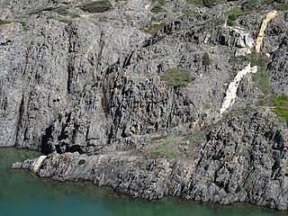
In geology, a shear zone is a thin zone within the Earth's crust or upper mantle that has been strongly deformed, due to the walls of rock on either side of the zone slipping past each other. In the upper crust, where rock is brittle, the shear zone takes the form of a fracture called a fault. In the lower crust and mantle, the extreme conditions of pressure and temperature make the rock ductile. That is, the rock is capable of slowly deforming without fracture, like hot metal being worked by a blacksmith. Here the shear zone is a wider zone, in which the ductile rock has slowly flowed to accommodate the relative motion of the rock walls on either side.

<span class="mw-page-title-main">Shear (geology)</span> Response of rock to deformation

In geology, shear is the response of a rock to deformation usually by compressive stress and forms particular textures. Shear can be homogeneous or non-homogeneous, and may be pure shear or simple shear. Study of geological shear is related to the study of structural geology, rock microstructure or rock texture and fault mechanics.

<span class="mw-page-title-main">Brittle–ductile transition zone</span> Strongest part of the Earths crust

The brittle-ductile transition zone is the zone of the Earth's crust that marks the transition from the upper, more brittle crust to the lower, more ductile crust. For quartz and feldspar-rich rocks in continental crust, the transition zone occurs at an approximate depth of 20 km, at temperatures of 250–400 °C. At this depth, rock becomes less likely to fracture, and more likely to deform ductilely by creep because the brittle strength of a material increases with confining pressure, while its ductile strength decreases with increasing temperature.

<span class="mw-page-title-main">Fracture (geology)</span> Geologic discontinuity feature, often a joint or fault

A fracture is any separation in a geologic formation, such as a joint or a fault that divides the rock into two or more pieces. A fracture will sometimes form a deep fissure or crevice in the rock. Fractures are commonly caused by stress exceeding the rock strength, causing the rock to lose cohesion along its weakest plane. Fractures can provide permeability for fluid movement, such as water or hydrocarbons. Highly fractured rocks can make good aquifers or hydrocarbon reservoirs, since they may possess both significant permeability and fracture porosity.

<span class="mw-page-title-main">Mantle convection</span> Gradual movement of the planets mantle

Mantle convection is the very slow creeping motion of Earth's solid silicate mantle as convection currents carry heat from the interior to the planet's surface.

In geology, a deformation mechanism is a process occurring at a microscopic scale that is responsible for changes in a material's internal structure, shape and volume. The process involves planar discontinuity and/or displacement of atoms from their original position within a crystal lattice structure. These small changes are preserved in various microstructures of materials such as rocks, metals and plastics, and can be studied in depth using optical or digital microscopy.

Material failure theory is an interdisciplinary field of materials science and solid mechanics which attempts to predict the conditions under which solid materials fail under the action of external loads. The failure of a material is usually classified into brittle failure (fracture) or ductile failure (yield). Depending on the conditions most materials can fail in a brittle or ductile manner or both. However, for most practical situations, a material may be classified as either brittle or ductile.

<span class="mw-page-title-main">Ductility (Earth science)</span>

In Earth science, ductility refers to the capacity of a rock to deform to large strains without macroscopic fracturing. Such behavior may occur in unlithified or poorly lithified sediments, in weak materials such as halite or at greater depths in all rock types where higher temperatures promote crystal plasticity and higher confining pressures suppress brittle fracture. In addition, when a material is behaving ductilely, it exhibits a linear stress vs strain relationship past the elastic limit.

<span class="mw-page-title-main">Eclogitization</span> The tectonic process in which the dense, high-pressure, metamorphic rock, eclogite, is formed

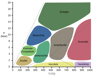
Eclogitization is the tectonic process in which the high-pressure, metamorphic facies, eclogite, is formed. This leads to an increase in the density of regions of Earth's crust, which leads to changes in plate motion at convergent boundaries.

Mountains are widely distributed across the surface of Io, the innermost large moon of Jupiter. There are about 115 named mountains; the average length is 157 km (98 mi) and the average height is 6,300 m (20,700 ft). The longest is 570 km (350 mi), and the highest is Boösaule Montes, at 17,500 metres (57,400 ft), taller than any mountain on Earth. Ionian mountains often appear as large, isolated structures; no global tectonic pattern is evident, unlike on Earth, where plate tectonics is dominant.

<span class="mw-page-title-main">Analogue modelling (geology)</span>

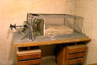
Analogue modelling is a laboratory experimental method using uncomplicated physical models with certain simple scales of time and length to model geological scenarios and simulate geodynamic evolutions.

<span class="mw-page-title-main">Geodynamics of terrestrial exoplanets</span>

The discovery of extrasolar Earth-sized planets has encouraged research into their potential for habitability. One of the generally agreed requirements for a life-sustaining planet is a mobile, fractured lithosphere cyclically recycled into a vigorously convecting mantle, in a process commonly known as plate tectonics. Plate tectonics provide a means of geochemical regulation of atmospheric particulates, as well as removal of carbon from the atmosphere. This prevents a “runaway greenhouse” effect that can result in inhospitable surface temperatures and vaporization of liquid surface water. Planetary scientists have not reached a consensus on whether Earth-like exoplanets have plate tectonics, but it is widely thought that the likelihood of plate tectonics on an Earth-like exoplanet is a function of planetary radius, initial temperature upon coalescence, insolation, and presence or absence of liquid-phase surface water.

<span class="mw-page-title-main">Numerical modeling (geology)</span> Technique to solve geological problems by computational simulation

In geology, numerical modeling is a widely applied technique to tackle complex geological problems by computational simulation of geological scenarios.

Ridge push is a proposed driving force for plate motion in plate tectonics that occurs at mid-ocean ridges as the result of the rigid lithosphere sliding down the hot, raised asthenosphere below mid-ocean ridges. Although it is called ridge push, the term is somewhat misleading; it is actually a body force that acts throughout an ocean plate, not just at the ridge, as a result of gravitational pull. The name comes from earlier models of plate tectonics in which ridge push was primarily ascribed to upwelling magma at mid-ocean ridges pushing or wedging the plates apart.

<span class="mw-page-title-main">Volcanic and igneous plumbing systems</span> Magma chambers

Volcanic and igneous plumbing systems (VIPS) consist of interconnected magma channels and chambers through which magma flows and is stored within Earth's crust. Volcanic plumbing systems can be found in all active tectonic settings, such as mid-oceanic ridges, subduction zones, and mantle plumes, when magmas generated in continental lithosphere, oceanic lithosphere, and in the sub-lithospheric mantle are transported. Magma is first generated by partial melting, followed by segregation and extraction from the source rock to separate the melt from the solid. As magma propagates upwards, a self-organised network of magma channels develops, transporting the melt from lower crust to upper regions. Channelled ascent mechanisms include the formation of dykes and ductile fractures that transport the melt in conduits. For bulk transportation, diapirs carry a large volume of melt and ascent through the crust. When magma stops ascending, or when magma supply stops, magma emplacement occurs. Different mechanisms of emplacement result in different structures, including plutons, sills, laccoliths and lopoliths.

References

  1. Ismail-Zadeh & Tackley 2010
  2. 1 2 3 4 Turcotte, D. L. and G. Schubert (2014). "Geodynamics."
  3. Winters, J. D. (2001). "An introduction to igenous and metamorphic petrology."
  4. Newman, W. I. (2012). Continuum Mechanics in the Earth Sciences. Cambridge University Press. ISBN   9780521562898.
  5. 1 2 Turcotte & Schubert 2002
  6. 1 2 3 Karato, Shun-ichiro (2008). "Deformation of Earth Materials: An Introduction to the Rheology of Solid Earth."
  7. Faul, U. H., J. D. F. Gerald and I. Jackson (2004). "Shear wave attenuation and dispersion in melt-bearing olivine
  8. Hager, B. H. and R. W. Clayton (1989). "Constraints on the structure of mantle convection using seismic observations, flow models, and the geoid." Fluid Mechanics of Astrophysics and Geophysics 4.
  9. Stein, C. (1995). "Heat flow of the Earth."
  10. Dziewonski, A. M. and D. L. Anderson (1981). "Preliminary reference Earth model." Physics of the Earth and Planetary Interiors 25(4): 297-356.
  11. Ribe, N. M. (1998). "Spouting and planform selection in the Rayleigh–Taylor instability of miscible viscous fluids." Journal of Fluid Mechanics 377: 27-45.
  12. Conrad, C. P. and C. Lithgow-Bertelloni (2004). "The temporal evolution of plate driving forces: Importance of "slab suction" versus "slab pull" during the Cenozoic." Journal of Geophysical Research 109(B10): 2156-2202.
  13. Bourdon, B., N. M. Ribe, A. Stracke, A. E. Saal and S. P. Turner (2006). "Insights into the dynamics of mantle plumes from uranium-series geochemistry." Nature 444(7): 713-716.
  14. Tackley, Paul J.; Xie, Shunxing; Nakagawa, Takashi; Hernlund, John W. (2005), "Numerical and laboratory studies of mantle convection: Philosophy, accomplishments, and thermochemical structure and evolution", Earth's Deep Mantle: Structure, Composition, and Evolution, American Geophysical Union, vol. 160, pp. 83–99, Bibcode:2005GMS...160...83T, doi:10.1029/160gm07, ISBN   9780875904252
Bibliography