Geostatistics is a branch of statistics focusing on spatial or spatiotemporal datasets. Developed originally to predict probability distributions of ore grades for mining operations, it is currently applied in diverse disciplines including petroleum geology, hydrogeology, hydrology, meteorology, oceanography, geochemistry, geometallurgy, geography, forestry, environmental control, landscape ecology, soil science, and agriculture. Geostatistics is applied in varied branches of geography, particularly those involving the spread of diseases (epidemiology), the practice of commerce and military planning (logistics), and the development of efficient spatial networks. Geostatistical algorithms are incorporated in many places, including geographic information systems (GIS) and the R statistical environment.
Finite-difference time-domain or Yee's method is a numerical analysis technique used for modeling computational electrodynamics. Since it is a time-domain method, FDTD solutions can cover a wide frequency range with a single simulation run, and treat nonlinear material properties in a natural way.
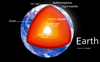
Earth's inner core is the innermost geologic layer of the Earth. It is primarily a solid ball with a radius of about 1,220 kilometres, which is about 20% of the Earth's radius or 70% of the Moon's radius.

Geodynamics is a subfield of geophysics dealing with dynamics of the Earth. It applies physics, chemistry and mathematics to the understanding of how mantle convection leads to plate tectonics and geologic phenomena such as seafloor spreading, mountain building, volcanoes, earthquakes, faulting and so on. It also attempts to probe the internal activity by measuring magnetic fields, gravity, and seismic waves, as well as the mineralogy of rocks and their isotopic composition. Methods of geodynamics are also applied to exploration of other planets.
An Atmospheric radiative transfer model, code, or simulator calculates radiative transfer of electromagnetic radiation through a planetary atmosphere, such as the Earth's.
CitCom is a finite element code designed to solve thermal convection problems relevant to earth's mantle released under the GNU General Public License. Written in C, the code's latest version, CitComS, runs on a variety of parallel processing computers, including shared and distributed memory platforms.
Michael Gurnis, is the John E. and Hazel S. Smits Professor of Geophysics at the California Institute of Technology.
The Community Surface Dynamics Modeling System (CSDMS) deals with the Earth's surface and the observable and projected changes constantly taking place – the ever-changing dynamic interface between lithosphere, hydrosphere, cryosphere and atmosphere.

Ascalaph Designer is a computer program for general purpose molecular modelling for molecular design and simulations. It provides a graphical environment for the common programs of quantum and classical molecular modelling ORCA, NWChem, Firefly, CP2K and MDynaMix . The molecular mechanics calculations cover model building, energy optimizations and molecular dynamics. Firefly covers a wide range of quantum chemistry methods. Ascalaph Designer is free and open-source software, released under the GNU General Public License, version 2 (GPLv2).

Peter Alfred Ziegler was a Swiss geologist, who made contributions to the understanding of the geological evolution of Europe and the North Atlantic borderlands, of intraplate tectonics and of plate tectonic controls on the evolution and hydrocarbon potential of sedimentary basins. Ziegler's career consists of 33 years as exploration geologist with the petroleum industry, 30 of which with Shell, and 20 years of university teaching and research.
Carmen Gaina is the Director of the Centre for Earth Evolution and Dynamics (CEED) a Norwegian Centre of Excellence hosted at the Department of Geosciences, University of Oslo, Norway.
Gerris is computer software in the field of computational fluid dynamics (CFD). Gerris was released as free and open-source software, subject to the requirements of the GNU General Public License (GPL), version 2 or any later.

Large low-shear-velocity provinces, LLSVPs, also called LLVPs or superplumes, are characteristic structures of parts of the lowermost mantle of the Earth. These provinces are characterized by slow shear wave velocities and were discovered by seismic tomography of the deep Earth. There are two main provinces: the African LLSVP and the Pacific LLSVP. Both extend laterally for thousands of kilometers and possibly up to 1000 km vertically from the core-mantle boundary. The Pacific LLSVP has specific dimensions of 3000 km across and 300 m higher than the surrounding ocean-floor, and is situated over four hotspots that suggest multiple mantle plumes underneath. These zones represent around 8% of the volume of the mantle. Other names for LLSVPs include superwells, thermo-chemical piles, or hidden reservoirs. Some of these names, however, are more interpretive of their geodynamical or geochemical effects, while many questions remain about their nature.

Behara Seshadri Daya Sagar, also known as B. S. Daya Sagar is an Indian mathematical geoscientist specializing in mathematical morphology. He is a professor of computer science at the Indian Statistical Institute, Bangalore. He is known as a specialist in mathematical morphology, fractal geometry. chaos theory, and their applications in geophysics, geographical information science, and computational geography. The Indian Geophysical Union awarded him the Krishnan Medal in 2002. He is the first Asian to receive the Georges Matheron Lectureship in 2011. In 2018, he received the IAMG Certificate of Appreciation by the International Association for Mathematical Geosciences for his work on the Handbook of Mathematical Geosciences.

The discovery of extrasolar Earth-sized planets has encouraged research into their potential for habitability. One of the generally agreed requirements for a life-sustaining planet is a mobile, fractured lithosphere cyclically recycled into a vigorously convecting mantle, in a process commonly known as plate tectonics. Plate tectonics provide a means of geochemical regulation of atmospheric particulates, as well as removal of carbon from the atmosphere. This prevents a “runaway greenhouse” effect that can result in inhospitable surface temperatures and vaporization of liquid surface water. Planetary scientists have not reached a consensus on whether Earth-like exoplanets have plate tectonics, but it is widely thought that the likelihood of plate tectonics on an Earth-like exoplanet is a function of planetary radius, initial temperature upon coalescence, insolation, and presence or absence of liquid-phase surface water.

GPlates is open-source application software offering a novel combination of interactive plate-tectonic reconstructions, geographic information system (GIS) functionality and raster data visualization.
Mark S. Ghiorso is an American geochemist who resides in Seattle, Washington. He is best known for creating MELTS, a software tool for thermodynamic modeling of phase equilibria in magmatic systems.
Louise H. Kellogg was an American geophysicist with expertise in chemical geodynamics and computational geophysics and experience in leading multidisciplinary teams to advance geodynamics modeling and scientific visualization. Kellogg was a Distinguished Professor at the University of California, Davis and director of the Computational Infrastructure for Geodynamics. She was also a major contributor to the Deep Carbon Observatory project of the Sloan Foundation.

In geology, numerical modeling is a widely applied technique to tackle complex geological problems by computational simulation of geological scenarios.
The Journal of Open Source Software is a peer-reviewed open-access scientific journal covering open-source software from any research discipline. The editor-in-chief is Arfon Smith who launched the journal in May 2016. The journal is a sponsored project of NumFOCUS and an affiliate of the Open Source Initiative. The journal uses GitHub as publishing platform.