Lajas is a town and municipality of Puerto Rico located in the Lajas Valley in southwestern Puerto Rico, on the southern coast of the island, bordering the Caribbean Sea, south of San Germán and Sabana Grande; east of Cabo Rojo; and west of Guánica. Lajas is spread over 11 barrios plus Lajas Pueblo. It is part of the San Germán-Cabo Rojo Metropolitan Statistical Area.

San Germán is a historic town and municipality located in the Sabana Grande Valley of southwestern region of Puerto Rico, south of Mayagüez and Maricao, north of Lajas, east of Hormigueros and Cabo Rojo, and west of Sabana Grande. San Germán is spread over eighteen barrios plus San Germán Pueblo. It is both a principal city of the San Germán–Cabo Rojo Metropolitan Statistical Area and the Mayagüez–San Germán–Cabo Rojo Combined Statistical Area. San Germán is the second oldest city of Puerto Rico, after San Juan, and its historic downtown is preserved as the San Germán Historic District.

Cabo Rojo is a city and municipality situated on the southwest coast of Puerto Rico and forms part of the San Germán–Cabo Rojo metropolitan area as well as the larger Mayagüez–San Germán–Cabo Rojo Combined Statistical Area.

Danza is a musical genre that originated in Ponce, a city in southern Puerto Rico. It is a popular turn-of-the-twentieth-century ballroom dance genre slightly similar to the waltz. Both the danza and its cousin the contradanza are sequence dances, performed to a pattern, usually of squares, to music that was instrumental. Neither the contradanza nor the danza were sung genres; this is a contrast to, for example, the habanera, which was a sung genre. There is some dispute as to whether the danza was in any sense a different dance from the contradanza, or whether it was just a simplification of the name. Through the first part of the 19th century the dance and its music became steadily more creolized. The music and the dance is creolized because composers were consciously trying to integrate African and European ideas because many of the people themselves were creoles, that is, born in the Caribbean; accepting their islands as their true and only homeland.

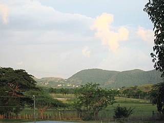
Cordillera Central, is the main mountain range in Puerto Rico. The range crosses the island from west to east and divides it into its northern and southern coastal plains. The Cordillera Central runs eastward from the municipality of Maricao in the west to Aibonito in the central eastern region, and on to the Caribbean in the southeast through the Sierra de Cayey.
Paradores in Puerto Rico is a brand of small inns similar to bed and breakfasts that have government permission to call themselves paradores based on a set of criteria. These inns are scattered across the island countryside, outside the main metropolitan area of San Juan. Often called "country inns" in English, paradores in Puerto Rico are known for their hospitality, affordable rates, exotic locations, and traditional Puerto Rican cuisine. They are frequented by guests looking to enjoy the local customs and charm.
The Residential Center of Educational Opportunities of Mayagüez ("C.R.O.E.M.") is a magnet high school, in Mayagüez in the United States insular area of Puerto Rico. This is the top specialized school operated by the Puerto Rico Department of Education, specialized in sciences & math, only the top students of Puerto Rico are selected to study here. This is a boarding school, here students can stay in the living facilities of the school, or also have the option to be a non-resident student. Apart from having college structured classes, schedules and highly prepared professors, come from public and private schools from all around the island. The school is recognized as one of the best on the island according to the Department of Education.

Puerto Rico Highway 116 (PR-116) is a main highway in the southwest part of Puerto Rico, beginning in Guánica, Puerto Rico at Puerto Rico Highway 2 to Lajas, Puerto Rico at Puerto Rico Highway 101.
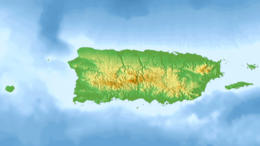
The Lajas Valley, or the Yauco-Boquerón Valley, is an anticlinal valley that runs 30 km long and 5 km wide east-to-west in southwestern Puerto Rico, within the municipalities of Lajas, Cabo Rojo, Guánica, and Sabana Grande. It is surrounded by the Cordillera Central and the Santa Marta hills to the north, the Sierra Bermeja to the south, the Boqueron Bay in Cabo Rojo to the west, and the Guánica Bay and southern karst to the east. The climate is considered moist to dry subhumid tropical. Its large extension and fertile soil have made it a good place for agriculture. However, it is one of the driest places of Puerto Rico, making irrigation necessary.

Isla Magueyes is a 7.2 hectares island 50 metres (160 ft) from the southwest coast of the island of Puerto Rico. It is encircled with mangrove and has an interior of dry scrub habitat, where it gets its name. It is named for the presence of many century plants or maguey. The surrounding shelf of the island is mostly coral reef. There are buildings on the western end of the island associated with the Department of Marine Sciences, University of Puerto Rico at Mayagüez. UPR- Mayagüez is an important center in the Atlantic region for the study of tropical marine science due to its location, facilities, and first-rate researchers. The research facilities includes the Puerto Rico Water Resources and Environmental Research Institute, the Caribbean Coral Reef Institute (CCRI), the Research and Development Center, the Agricultural Research Station and the Caribbean Atmospheric Research Center (ATMOSCarib).

Porta del Sol, or simply West Region, is a tourism region in western Puerto Rico. Porta del Sol was the first tourism region to be established by the Puerto Rico Tourism Company. It consists of 17 municipalities in the western area: Quebradillas, Isabela, San Sebastián, Moca, Aguadilla, Aguada, Rincón, Añasco, Mayagüez, Las Marías, Maricao, Hormigueros, San Germán, Sabana Grande, Guánica, Lajas and Cabo Rojo.

Puerto Rico Highway 142 (PR-142) is a north–south road that connects the northern region of Puerto Rico with the municipality of Corozal. With a length of about 8.2 kilometers (5.1 mi), PR-142 crosses the municipalities of Dorado, Toa Alta and Corozal, extending from PR-2 in Dorado to PR-159 near downtown Corozal.

Río Lajas is a barrio in the municipality of Dorado, Puerto Rico. Its population in 2010 was 2,559.

Puerto Rico senatorial district V, also known as the senatorial district of Ponce, is one of the eight senatorial districts of Puerto Rico. It is currently represented by Marially González Huertas and Ramón Ruiz Nieves.
Marcos A. "Turín" Irizarry Pagán is a Puerto Rican politician and was the mayor of Lajas. Irizarry is affiliated with the Popular Democratic Party (PPD) and has served as mayor for two separate instances. He first served from 1997 to 2009, and was reelected again in 2013. Marcos Irizarry has an associate degree at the level of master's degree in mathematics at the University of Phoenix holds 30 credits at the level of master's degree in administration and Supervision. Until 1987, Irizarry served as Professor and supervisor of mathematics of the District School of Lajas, while teaching several courses at the Interamerican University of Puerto Rico, San German campus.

The Fiesta Nacional de la Danza, also known as Semana de la Danza Puertorriqueña, is a cultural celebration that takes place every year in Ponce, Puerto Rico. The festival centers on the danza, a musical genre native from the city of Ponce and oftentimes called "Puerto Rico's classical music" with rhythm, tune, and cadence that are similar to the waltz. The celebration lasts a week and takes place in mid-May. It is sponsored by the Ponce Municipal Government and the Institute of Puerto Rican Culture.
Pedro Sánchez de Mathos was the first municipal magistrate of Ponce, Puerto Rico, in 1692. He was appointed mayor by the Governor of Puerto Rico, Juan Robles de Lorenzana. He had been regidor in San German in 1676 and was its mayor in 1688.
Juan Lacot Feliú was Mayor of the city of Ponce from 1 September 1848 to 30 September 1849.
Francisco José de Mercado was interim mayor of Ponce, Puerto Rico, from early in 1822 to 31 December 1822.
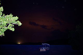
The Puerto Mosquito Bioluminescent Bay, or Mosquito Bio Bay, is a bay in the island of Vieques famous for its bioluminescence produced by the dinoflagellate Pyrodinium bahamense, which glows blue when agitated. This species of phytoplankton is found in bays in the Virgin Islands, Puerto Rico and The Bahamas.