
Collier County is a county in the U.S. state of Florida. As of the 2020 census, its population was 375,752; an increase of 16.9% since the 2010 United States Census. Its county seat is East Naples, where the county offices were moved from Everglades City in 1962.

Everglades City is a city in Collier County, Florida, United States, of which it was once the county seat. The City of Everglades City is part of the Naples–Marco Island Metropolitan Statistical Area, which is included in the Cape Coral-Fort Myers-Naples Combined Statistical Area. The Gulf Coast Visitor Center for Everglades National Park is located in Everglades City. As of the 2020 US census, the population was 352, down from 400 in the 2010 US census.

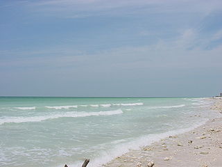
Marco Island is a city and barrier island in Collier County, Florida, 20 miles (32 km) south of Naples on the Gulf Coast of the United States. It is the largest barrier island in Southwest Florida's Ten Thousand Islands area, which extends southerly to Cape Sable. Marco Island is home to an affluent beach community with resort amenities.

Naples is a city in Collier County, Florida, United States. As of the 2020 census, the population was 19,115, down from 19,539 at the 2010 census. Naples is a principal city of the Naples–Marco Island metropolitan area, which had a population of about 375,752 as of 2020. Naples' USPS City population includes most of the communities in Collier County with the notable exceptions of Immokalee, Marco Island, Ave Maria, Everglades City, and a few others, and thus Naples' USPS City population is approximately 333,083.

Flamingo is the southernmost headquarters of Everglades National Park, in Monroe County, Florida, United States. Flamingo is one of the two end points of the 99-mile (159-km) Wilderness Waterway, and the southern end of the only road through the park from Florida City. It began as a small coastal settlement on the eastern end of Cape Sable on the southern tip of the Florida peninsula, facing Florida Bay. The actual town of Flamingo was located approximately 4+1⁄2 miles west of the current Flamingo campground area. All that remains of the former town are a few remnants of building foundations, and it is considered a ghost town.

The Gulf of Naples, also called the Bay of Naples, is a roughly 15-kilometer-wide (9.3 mi) gulf located along the south-western coast of Italy. It opens to the west into the Mediterranean Sea. It is bordered on the north by the cities of Naples and Pozzuoli, on the east by Mount Vesuvius, and on the south by the Sorrento Peninsula and the main town of the peninsula, Sorrento. The Peninsula separates the Gulf of Naples from the Gulf of Salerno, which includes the Amalfi Coast.

Collier Boulevard is a nearly 27-mile-long (43 km) north–south divided highway that extends from the south end of Marco Island through central Collier County to CR 846 north of Golden Gate. State-maintained segments of Collier Boulevard are designated as State Road 951, which previously existed over the entire route from CR 92 on Marco Island to CR 846. County-maintained segments are County Road 951, which were relinquished from state control in the 1980s.
Honeymoon Island State Park is a Florida State Park located on Honeymoon Island, a barrier island across St. Joseph Sound from Dunedin, Palm Harbor, Ozona, and Crystal Beach. The park is 385 acres (1.6 km2) in land area with 2,400 acres (10 km2) submerged and 4 miles (6 km) of beach. It lies at the western end of Causeway Boulevard, which becomes Curlew Road east of Alternate US 19. Its address is 1 Causeway Blvd. Consistently receiving more than one million visitors each year, it is the most-visited state park in Florida.
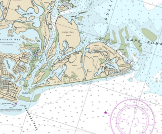
Cape Romano is a cape on the Gulf Coast of Florida, United States. It is on Cape Romano Island, one of a group of islands known collectively as Kice-Morgan Island.
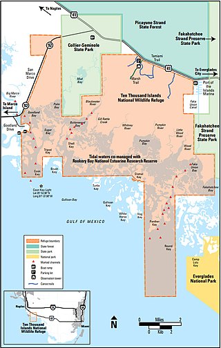
The Ten Thousand Islands are a chain of islands and mangrove islets off the coast of southwest Florida, between Cape Romano and the mouth of the Lostmans River. Some of the islands are high spots on a submergent coastline. Others were produced by mangroves growing on oyster bars. Despite the name, the islets in the chain only number in the hundreds.

The 1982 Florida subtropical storm, officially known as Subtropical Storm One, was the only subtropical cyclone of the exceptionally inactive 1982 Atlantic hurricane season. The storm originated from two different systems around the Gulf of Mexico and Caribbean on June 16. The systems merged into trough while a circulation began to form off the coast of Florida on June 18. The depression made landfall in Florida and strengthened into a storm over land. The storm entered the Atlantic Ocean and headed to the northeast, becoming extratropical on June 20 near Newfoundland. The storm was the only system of 1982 to affect the eastern half of the United States, and it caused three fatalities and caused $10 million in damage.
Rookery Bay National Estuarine Research Reserve protects 110,000 acres of coastal lands and waters at the northern end of the Ten Thousand Islands on the gulf coast of Florida, representing one of the few remaining undisturbed mangrove estuaries in North America.

The effects of Hurricane Wilma in Florida resulted in the storm becoming one of the costliest tropical cyclones in Florida history. Wilma developed in the Caribbean Sea just southwest of Jamaica on October 15 from a large area of disturbed weather. After reaching tropical storm intensity on October 17 and then hurricane status on October 18, the system explosively deepened, peaking as the strongest tropical cyclone ever recorded in the Atlantic basin. Wilma then slowly weakened while trekking to the northwest and fell to Category 4 intensity by the time it struck the Yucatán Peninsula on October 22. Thereafter, a strong cold front swept the storm northeastward into Florida on October 24, with landfall occurring near Cape Romano as a Category 3 hurricane with winds of 120 mph (190 km/h). Wilma continued rapidly northeastward into the Atlantic Ocean and became extratropical on October 26.

Much of the state of Florida is situated on a peninsula between the Gulf of Mexico, the Atlantic Ocean, and the Straits of Florida. Spanning two time zones, it extends to the northwest into a panhandle along the northern Gulf of Mexico. It is bordered on the north by the states of Georgia and Alabama, on the west, at the end of the panhandle, by Alabama. It is near The Bahamas, and several Caribbean countries, particularly Cuba. Florida has 131 public airports, and more than 700 private airports, airstrips, heliports, and seaplane bases. Florida is one of the largest states east of the Mississippi River, and only Alaska and Michigan are larger in water area.

Marina Grande is the main port of the island of Capri in Italy, to the north of the main town of Capri and at the foot of Mount Solaro.
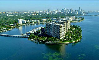
Grove Isle is a 20-acre (81,000 m2) island lying off the north-east coast of Miami's Coconut Grove neighborhood. Three waterfront hi-rise residences have been built on the island which were master-planned to include a resort hotel, restaurants, marina, club amenities and services.
Coconut island was a river island in the mouth of the Marco River in Collier County, Florida.

Hurricane Irma was the costliest tropical cyclone in the history of the U.S. state of Florida, before being surpassed by Hurricane Ian in 2022. Irma developed from a tropical wave near the Cape Verde Islands on August 30, 2017. The storm quickly became a hurricane on August 31 and then a major hurricane shortly thereafter, but would oscillate in intensity over the next few days. By September 4, Irma resumed strengthening, and became a powerful Category 5 hurricane on the following day. The cyclone then struck Saint Maarten and the British Virgin Islands on September 6 and later crossed Little Inagua in the Bahamas on September 8. Irma briefly weakened to a Category 4 hurricane, but re-intensified into a Category 5 hurricane before making landfall in the Sabana-Camagüey Archipelago of Cuba. After falling to Category 3 status due to land interaction, the storm re-strengthened into a Category 4 hurricane in the Straits of Florida. Irma struck Florida twice on September 10 – the first as a Category 4 at Cudjoe Key and the second on Marco Island as a Category 3. The hurricane weakened significantly over Florida, and was reduced to a tropical storm, before exiting the state into Georgia on September 11.
The Atlantic Coast Line Railroad's Lakeland—Fort Myers Line was one of the railroad company's secondary main lines in Central and Southwest Florida. It was built incrementally in the late 1800s and early 1900s. Parts of the line are still active today.
