Related Research Articles

Lake Michigan is one of the five Great Lakes of North America. It is the second-largest of the Great Lakes by volume and the third-largest by surface area, after Lake Superior and Lake Huron. To the east, its basin is conjoined with that of Lake Huron through the 3+1⁄2-mile (5.6-kilometer) wide, 295-foot deep Straits of Mackinac, giving it the same surface elevation as its easterly counterpart; the two are geologically a single lake.

Lake Superior is the largest freshwater lake in the world by surface area and the third-largest by volume, holding 10% of the world's surface fresh water. Located in central North America, it is the northernmost and westernmost of the Great Lakes of North America, straddling the Canada–United States border with the Canadian province of Ontario to the north and east and the U.S. states of Minnesota to the west and Michigan and Wisconsin to the south. It drains into Lake Huron via St. Marys River, then through the lower Great Lakes to the St. Lawrence River and ultimately the Atlantic Ocean.

The Mariana Trench is an oceanic trench located in the western Pacific Ocean, about 200 kilometres (124 mi) east of the Mariana Islands; it is the deepest oceanic trench on Earth. It is crescent-shaped and measures about 2,550 km (1,580 mi) in length and 69 km (43 mi) in width. The maximum known depth is 10,984 ± 25 metres at the southern end of a small slot-shaped valley in its floor known as the Challenger Deep. The deepest point of the trench is more than 2 km (1.2 mi) farther from sea level than the peak of Mount Everest.

In physical geography, a fjord or fiord is a long, narrow sea inlet with steep sides or cliffs, created by a glacier. Fjords exist on the coasts of Antarctica, the Arctic, and surrounded landmasses of the northern and southern hemispheres. Norway's coastline is estimated to be 29,000 km (18,000 mi) long with its nearly 1,200 fjords, but only 2,500 km (1,600 mi) long excluding the fjords.

Lake Baikal is a rift lake in Russia. It is situated in southern Siberia, between the federal subjects of Irkutsk Oblast to the northwest and the Republic of Buryatia to the southeast. At 31,722 km2 (12,248 sq mi)—slightly larger than Belgium—Lake Baikal is the world's seventh-largest lake by surface area. However, because it is also the deepest lake, with a maximum depth of 1,642 metres, Lake Baikal is the world's largest freshwater lake by volume, containing 23,615.39 km3 (5,670 cu mi) of water or 22–23% of the world's fresh surface water, more than all of the North American Great Lakes combined. It is also the world's oldest lake at 25–30 million years, and among the clearest.

Lake Chelan is a narrow, 50.5 mi (81.3 km) long lake in Chelan County, north-central Washington state, U.S. It is an overdeepened lake and resembles a fjord, with an average width of 1.3 mi (2.1 km). Near its upper end, the lake surface lies more than 6,600 ft (2,000 m) below peaks less than 3 mi (4.8 km) away. Before 1927, Lake Chelan was the largest natural lake in the state in terms of both surface area and water volume. Upon the completion of Lake Chelan Dam in 1927, the elevation of the lake was increased by 21 ft (6.4 m) to its present maximum-capacity elevation of 1,100 ft (340 m).

A deep-submergence vehicle (DSV) is a deep-diving crewed submersible that is self-propelled. Several navies operate vehicles that can be accurately described as DSVs. DSVs are commonly divided into two types: research DSVs, which are used for exploration and surveying, and DSRVs, which are intended to be used for rescuing the crew of a sunken navy submarine, clandestine (espionage) missions, or both. DSRVs are equipped with docking chambers to allow personnel ingress and egress via a manhole.

The Puerto Rico Trench is located on the boundary between the Caribbean Sea and the Atlantic Ocean. The oceanic trench, the deepest in the Atlantic, is associated with a complex transition between the Lesser Antilles subduction zone to the south and the major transform fault zone or plate boundary, which extends west between Cuba and Hispaniola through the Cayman Trough to the coast of Central America.

Mir was a class of two self-propelled deep-submergence vehicles. The project was initially developed by the USSR Academy of Sciences along with Lazurit Central Design Bureau, and two vehicles were ordered from Finland. The Mir-1 and Mir-2, delivered in 1987, were designed and built by the Finnish company Rauma-Repola's Oceanics subsidiary. The project was carried out under the supervision of constructors and engineers of the Shirshov Institute of Oceanology.
Salvatnet is a lake in the municipalities of Namsos and Nærøysund in Trøndelag county, Norway. With its deepest depth of 482 metres (1,581 ft), it is Norway's and Europe's second-deepest lake, after Hornindalsvatnet. Alternate sources give the depth as either 464 metres (1,522 ft) or 482 metres (1,581 ft) at the deepest point. The lake sits very close to the ocean, about 9 metres (30 ft) above sea level at the surface and reaches to a depth of 473 metres (1,552 ft) below sea level. It is a very large lake with an area of 44.96 square kilometres (17.36 sq mi), a volume of 6.97 cubic kilometres (1.67 cu mi), and a shoreline that is 105.61 kilometres (65.62 mi) around.
The Large Lakes Observatory is a research institute located in Duluth, Minnesota, USA which studies the major lakes of the world. The researchers focus on a variety of sciences including aquatic chemistry, geochemistry and paleoclimatology. Its stated purpose dedicates the LLO to "performing innovative, cross-disciplinary research, education, and outreach that advance scientific understanding of Earth’s large lakes for the benefit of society and the sustainability of freshwaters." The parent institution of LLO is the University of Minnesota Duluth.

Loch Ness is a large freshwater loch in the Scottish Highlands extending for approximately 37 kilometres southwest of Inverness. It takes its name from the River Ness, which flows from the northern end. Loch Ness is best known for claimed sightings of the cryptozoological Loch Ness Monster, also known affectionately as "Nessie". It is one of a series of interconnected, murky bodies of water in Scotland; its water visibility is exceptionally low due to the high peat content of the surrounding soil. The southern end connects to Loch Oich by the River Oich and a section of the Caledonian Canal. The northern end connects to Loch Dochfour via the River Ness, which then ultimately leads to the North Sea via the Moray Firth.

CURV-III was the fourth generation of the United States Navy Cable-controlled Undersea Recovery Vehicle (CURV). CURV was a prototype for remotely operated underwater vehicles and a pioneer for teleoperation. It became famous in 1966 when CURV-I was used to recover a hydrogen bomb from the floor of the Mediterranean Sea. In 1973, CURV-III performed the deepest underwater rescue in history when it rescued two men 1,575 feet (480 m) from the ocean surface who were stranded 76 hours in the submersible Pisces III with just minutes of air remaining. The CURV-III became known in the Great Lakes region in 1976 when it was used to survey the wreck of the SS Edmund Fitzgerald. CURV-21 is the current generation that replaced CURV-III.
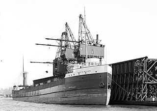
The Great Lakes freighter SS Scotiadoc was a 424 feet (129 m) long, 48 feet (15 m) wide, and 23.75 feet (7.24 m) deep, dry bulk freighter of typical construction style for the early 1900s, primarily designed for the iron ore, coal, and grain trades on the Great Lakes. Commissioned by the Lakewood Steamship Co. of Cleveland, Ohio, SS Martin Mullen was launched as hull number 422 by American Ship Building Co. of Columbus.
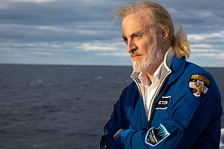
Victor Lance Vescovo is an American private equity investor, retired naval officer, sub-orbital spaceflight participant, and undersea explorer. He was a co-founder and managing partner of private equity company Insight Equity Holdings from 2000-2023. Vescovo achieved the Explorers Grand Slam by reaching the North and South Poles and climbing the Seven Summits, and he then visited the deepest points of all of Earth's five oceans during the Five Deeps Expedition of 2018–2019.
Tally Lake is a freshwater lake located in Flathead County, Montana in the northwestern region of the United States. The lake is about 20 miles (32 km) west of the town of Whitefish. It is a popular lake for recreational activities including fishing, boating, swimming and cliff jumping, and hiking on the surrounding trails, and is notable for its great depth and unusual geology. The lake's surface area is over 1,200 acres (490 ha). The lake is located at 3,356 feet (1,023 m) above sea level. It is about 445 feet (136 m) deep at its deepest point, making it the deepest lake in Montana and the deepest natural lake. Despite its large volume, the lake tends to be warm in late summer because its waters are darkly colored due to high levels of tannins. These cause the lake to absorb and retain more heat than comparatively clearer bodies of water in the region.

Andreas Buchwald Rechnitzer was an American oceanographer. With Carl Hubbs, he discovered the striped yellow butterfly fish that served as the logo of the Birch Aquarium. He helped develop the first SCUBA diving training program for ocean scientists, which included such innovations as ditch-and-don, buddy breathing, and the buddy system. He was a member of the US Navy Office of Naval Research team that negotiated the purchase of the bathyscape Trieste, and was the scientist in charge of Project Nekton in 1960, during which the Trieste entered the Challenger Deep, the deepest surveyed point in the world's oceans. For this he received the Navy Distinguished Civilian Service Award. He joined the scientific staff of the Chief of Naval Operations, where he was the Oceanographer of the Navy from 1970 to 1984, and was the Senior Scientist at Science Applications International Corporation from 1985 to 1998.
References
- ↑ "Variations In Sediment Accumulation Rates And The Flux Of Labile Organic Matter In Eastern Lake Superior Basins". The Journal of Great Lakes Research. 1989. Archived from the original on 2012-12-03. Retrieved 2009-08-09.
- ↑ "School of Freshwater Sciences: People". 2017. Retrieved 2017-09-20.
| | This article about an American scientist is a stub. You can help Wikipedia by expanding it. |
| | This biographical article about an Earth scientist is a stub. You can help Wikipedia by expanding it. |