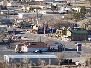
Beatty is an unincorporated town along the Amargosa River in Nye County, Nevada, United States. U.S. Route 95 runs through the town, which lies between Tonopah, about 90 miles (140 km) to the north and Las Vegas, about 120 miles (190 km) to the southeast. State Route 374 connects Beatty to Death Valley National Park, about 8 miles (13 km) to the west.

The Funeral Mountains is a short, arid mountain range in the United States along the California-Nevada border approximately 100 mi (160 km) west of Las Vegas. The mountains are considered a subrange of the Amargosa Range that form the eastern wall of Death Valley.

Amargosa Valley is an unincorporated town located on U.S. Route 95 in Nye County, in the U.S. state of Nevada.
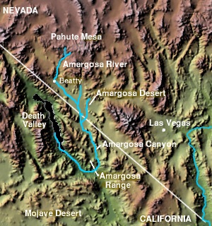
The Amargosa Valley is the valley through which the Amargosa River flows south, in Nye County, southwestern Nevada and Inyo County in the state of California. The south end is alternately called the "Amargosa River Valley'" or the "Tecopa Valley." Its northernmost point is around Beatty, Nevada and southernmost is Tecopa, California, where the Amargosa River enters into the Amargosa Canyon.
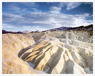
Places of interest in the Death Valley area are mostly located within Death Valley National Park in eastern California.

The Amargosa Desert is located in Nye County in western Nevada, United States, along the California–Nevada border, comprising the northeastern portion of the geographic Amargosa Valley, north of the Ash Meadows National Wildlife Refuge.

Area 25 is the largest named area in the Nevada National Security Site at 254 square miles (660 km2), and has its own direct access from Route 95. Area 25 is commonly called "Jackass Flats" because it is composed primarily of a shallow alluvial basin by that name.

Bays Mountain is a ridge of the Ridge-and-Valley Appalachians, located in East Tennessee. It runs southwest to northeast, from just south of Knoxville to Kingsport.

The Toquima Range is a mountain range, located primarily in Nye County with a small extension into Lander County, in Nevada, United States. Most of the range is included within the Humboldt-Toiyabe National Forest. The range reaches a maximum elevation of 11,949 feet (3,642 m) at the southern summit of Mount Jefferson. From Hickison Summit on U.S. Route 50, the range runs for approximately 71 miles (114 km) to the south-southwest. To its west are Big Smoky Valley, scenic State Route 376, and the large Toiyabe Range. To the east are remote Monitor Valley and the Monitor Range. Lying to the south of the range are U.S. Route 6 (Nevada) and the community of Tonopah, while to the north is U.S. Route 50, leading to the small community of Austin.

Dante's View is a viewpoint terrace at 1,669 m (5,476 ft) height, on the north side of Coffin Peak, along the crest of the Black Mountains, overlooking Death Valley. Dante's View is about 25 km (16 mi) south of Furnace Creek in Death Valley National Park.

The Bullfrog Hills are a small mountain range of the Mojave Desert in southern Nye County, southwestern Nevada. Bullfrog Hills was so named from a fancied resemblance of its ore to the color of a bullfrog.

The Cactus Range is a small mountain range in Nye County, Nevada. The range lies southwest of Cactus Flat and north of Pahute Mesa. Goldfield lies 23 mi (37 km) to the west in Esmeralda County. The range lies within the restricted area of the Tonopah Test Range.

The Bare Mountain Range is a mountain range in southern Nye County, Nevada, in the United States. Bare Mountain and Wildcat Peak are the high points of the range.

Bonnie Claire is a ghost town located in Nye County, Nevada. The settlement is located on the edge of Sarcobatus Flat adjacent to Nevada State Route 267. The mines of Slate Ridge lie to the northwest and the northernmost spur of the Amargosa Range, the Grapevine Mountains, is just to the south of the townsite. Bonnie Claire Flat extends to the southwest between the Slate Ridge and the Grapevines to the California border.

Carrara is a ghost town in Nye County, Nevada. The townsite is located in the Amargosa Desert adjacent to US Route 95 about 8.5 miles southeast of Beatty. The old Tonopah and Tidewater Railroad line was about one half mile to the southwest. An old road, previously a railroad grade, runs straight for about 3 miles to the northeast up Carrara Canyon on the southeast flank of the Bare Mountains to an old marble quarry. The quarry is about 1400 feet higher in elevation than the townsite.

The Pahute Mesa is a large, 60 miles (97 km) long mesa in southern Nye County, Nevada. The mesa's southeast region lies in the Nevada Test Site which is southeast; the region in the test site is called Pahute Mesa, one of the major test site sub-regions.
Sarcobatus Flat is a closed valley in western Nye County, Nevada between Goldfield and Beatty. The Bullfrog Hills form the southern boundary and the Grapevine Mountains along with Bonnie Claire Flat form the western boundary. Pahute Mesa bounds the area to the east and north. To the north the flat is contiguous with Lida Valley and Stonewall Flat.
Oasis Valley is a valley in the Amargosa Desert near Beatty in Nye County, western Nevada. The valley forms part of the southern drainage of Pahute Mesa. The Amargosa River flows through the Oasis Valley between the Bare Mountains and the Bullfrog Hills to the Amargosa Valley.
Crater Flat is a flat in the Amargosa Desert in Nye County, western Nevada. The flat lies between Yucca Mountain on the east and the Bare Mountains to the west. The south end of the flat borders the Amargosa Valley.
