Janesville (town), Wisconsin

Last updated

Town of Janesville, Wisconsin
Rock County Wisconsin incorporated and unincorporated areas Janesville (town) highlighted.svg
Location in Rock County and the state of Wisconsin.
Coordinates: 42°43′32″N89°4′34″W / 42.72556°N 89.07611°W / 42.72556; -89.07611
Country Flag of the United States.svg  United States
State Flag of Wisconsin.svg  Wisconsin
County Rock
Area
  Total28.6 sq mi (74.0 km2)
  Land28.1 sq mi (72.7 km2)
  Water0.5 sq mi (1.2 km2)
Elevation
[1]
863 ft (263 m)
Population
 (2020)
  Total3,665
  Density133.5/sq mi (51.6/km2)
Time zone UTC-6 (Central (CST))
  Summer (DST) UTC-5 (CDT)
Area code 608
FIPS code 55-37850 [2]
GNIS feature ID1583449 [1]
Websitetownofjanesville.org

The Town of Janesville is a located in Rock County, Wisconsin, United States. The population was 3,665 at the 2020 census. The City of Janesville is located to the southeast of and adjacent to the town. The unincorporated communities of Anderson and Leyden are located in the town.

Contents

Geography

According to the United States Census Bureau, the town has a total area of 28.6 square miles (74.0 km2), of which, 28.1 square miles (72.8 km2) of it is land and 0.5 square miles (1.2 km2) of it (1.65%) is water.

One of the lakes located in the Town of Janesville is Gibbs Lake.

Demographics

As of the census [2] of 2000, there were 3,750 people, 1,137 households, and 908 families residing in the town. The population density was 133.5 people per square mile (51.5/km2). There were 1,206 housing units at an average density of 42.9 per square mile (16.6/km2). The racial makeup of the town was 93.20% White, 4.67% Black or African American, 0.27% Native American, 0.48% Asian, 0.05% Pacific Islander, 0.67% from other races, and 0.67% from two or more races. 1.47% of the population were Hispanic or Latino of any race.

There were 1,137 households, out of which 34.1% had children under the age of 18 living with them, 72.5% were married couples living together, 4.5% had a female householder with no husband present, and 20.1% were non-families. 15.3% of all households were made up of individuals, and 4.7% had someone living alone who was 65 years of age or older. The average household size was 2.67 and the average family size was 2.98.

In the town, the population was spread out, with 22.2% under the age of 18, 8.7% from 18 to 24, 30.5% from 25 to 44, 26.0% from 45 to 64, and 12.6% who were 65 years of age or older. The median age was 40 years. For every 100 females, there were 118.7 males. For every 100 females age 18 and over, there were 120.4 males.

The median income for a household in the town was $68,567, and the median income for a family was $71,523. Males had a median income of $46,131 versus $27,866 for females. The per capita income for the town was $25,656. About 1.7% of families and 2.1% of the population were below the poverty line, including 1.8% of those under age 18 and 2.0% of those age 65 or over.

Related Research Articles

<span class="mw-page-title-main">Big River, California</span> Census-designated place in California, United States

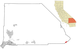
Big River is a census-designated place (CDP) in San Bernardino County, California, United States. The population was 1,084 at the 2020 census, down from 1,327 at the 2010 census.

<span class="mw-page-title-main">Ponderay, Idaho</span> City in Idaho, United States

Ponderay is a city in Bonner County, Idaho. The population was 1,137 at the 2010 census, up from 638 in 2000. Ponderay's city motto is "Little City with the Big Future". Its name is an English phonetic spelling of the French words “Pend Oreille”, the name of the lake the city sits upon.

<span class="mw-page-title-main">Converse, Indiana</span> Town in Indiana, United States

Converse is a town in Jackson Township, Miami County, and Richland Township, Grant County, in the U.S. state of Indiana. The population was 1,161 at the 2020 census.

<span class="mw-page-title-main">Janesville, Iowa</span> City in Iowa, United States

Janesville is a city in Black Hawk and Bremer counties in the U.S. state of Iowa. The population was 1034 at the 2020 census. It is part of the Waterloo–Cedar Falls Metropolitan Statistical Area.

<span class="mw-page-title-main">Mulberry, Kansas</span> City in Crawford County, Kansas

Mulberry is a city in Crawford County, Kansas, United States. As of the 2020 census, the population of the city was 409.

<span class="mw-page-title-main">Westfield, Maine</span> Town in the state of Maine, United States

Westfield is a town in Aroostook County, Maine, United States. The population was 455 at the 2020 census.

Beals is a town in Washington County, Maine, United States, located on an island opposite Jonesport. The town was named after Manwarren Beal, an early settler. The population was 443 at the 2020 census.

<span class="mw-page-title-main">Janesville, Minnesota</span> City in Minnesota, United States

Janesville is a city in Waseca County, Minnesota, United States. The population was 2,256 at the 2010 census.

Woodland Township is a township in Wright County, Minnesota, United States. The population was 1,137 at the 2000 census.

<span class="mw-page-title-main">Meridian, Pennsylvania</span> Census-designated place in Pennsylvania, United States

Meridian is a census-designated place (CDP) in Butler County, Pennsylvania, United States. The population was 3,881 at the 2010 census.

<span class="mw-page-title-main">Glen Hope, Pennsylvania</span> Borough in Pennsylvania, United States

Glen Hope is a borough in Clearfield County, Pennsylvania, United States. The population was 127 at the 2020 census.

<span class="mw-page-title-main">Sylvester, West Virginia</span> Town in West Virginia, United States

Sylvester is a town in Boone County, West Virginia, United States, along the Big Coal River. The population was 166 at the 2020 census. Sylvester was incorporated on April 11, 1952, by the Boone County Circuit Court. Sylvester bears the name of a family of settlers.

<span class="mw-page-title-main">Worthington, West Virginia</span> Town in West Virginia, United States

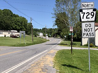
Worthington is a town in Marion County, West Virginia, United States. The population was 158 at the 2010 census. Worthington was incorporated in 1893 and named for Colonel George Worthington, an early settler. U.S. Route 19 passes through the town.

<span class="mw-page-title-main">Calamus, Wisconsin</span> Town in Wisconsin, United States

Calamus is a town in Dodge County, Wisconsin, United States. The population was 1,005 at the 2000 census. The unincorporated community of South Beaver Dam is located in the town. The unincorporated community of Lost Lake is also located partially in the town.

<span class="mw-page-title-main">Frederic, Wisconsin</span> Village in Wisconsin, United States

Frederic is a village in Polk County, Wisconsin, United States. The population was 1,137 at the 2010 census. It was established as a village in 1901.

<span class="mw-page-title-main">Harmony, Rock County, Wisconsin</span> Town in Wisconsin, United States

The Town of Harmony is a town located in Rock County, Wisconsin, United States. The population was 2,569 at the 2020 census. The city of Janesville is adjacent to the town.

<span class="mw-page-title-main">Rock, Rock County, Wisconsin</span> Town in Wisconsin, United States

The Town of Rock is a located in Rock County, Wisconsin, United States. The population was 2,981 at the 2020 census. The unincorporated community of Afton is in the town.

<span class="mw-page-title-main">Oregon, Wisconsin</span> Village in Wisconsin, United States

Oregon is a village in Dane County, Wisconsin. As of the census of 2020, the population was 11,179. Oregon is part of the Madison Metropolitan Statistical Area. The village is located mostly within the Town of Oregon.

<span class="mw-page-title-main">Rosendale, Wisconsin</span> Village in Wisconsin, United States

Rosendale is a village in Fond du Lac County, Wisconsin, United States. The population was 1,063 at the 2010 census. The village is located partially within the Town of Rosendale and partially within the Town of Springvale.

The Town of Potosi is located in Grant County, Wisconsin, United States. The population was 831 at the 2000 census. The Village of Potosi and the unincorporated communities of British Hollow, Buena Vista, Rockville, and Van Buren are located in the town.

References

  1. 1 2 "US Board on Geographic Names". United States Geological Survey. October 25, 2007. Retrieved January 31, 2008.
  2. 1 2 "U.S. Census website". United States Census Bureau . Retrieved January 31, 2008.