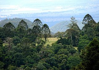
Bunya Mountains is a national park in the South Burnett Region, Queensland, Australia.

Araucaria bidwillii, commonly known as the bunya pine and sometimes referred to as the false monkey puzzle tree, is a large evergreen coniferous tree in the plant family Araucariaceae. It is found naturally in south-east Queensland Australia and two small disjunct populations in north eastern Queensland's World Heritage listed Wet Tropics. There are many old planted specimens in New South Wales, and around the Perth, Western Australia metropolitan area. They can grow up to 30–45 m (98–148 ft). The tallest presently living is one in Bunya Mountains National Park, Queensland which was reported by Robert Van Pelt in January 2003 to be 169 feet (51.5 m) in height.

Toowoomba is a city in the Toowoomba Region of the Darling Downs, Queensland, Australia. It is 125 km (78 mi) west of Queensland's capital city Brisbane by road. The urban population of Toowoomba as of the 2021 Census was 142,163, having grown at an average annual rate of 1.45% over the previous two decades. Toowoomba is the second-most-populous inland city in the country after the national capital of Canberra and hence the largest city on the Darling Downs, and it is among the largest regional centres in Queensland. It is also referred to as the capital of the Darling Downs.

The Darling Downs is a farming region on the western slopes of the Great Dividing Range in southern Queensland, Australia. The Downs are to the west of South East Queensland and are one of the major regions of Queensland. The name was generally applied to an area approximating to that of the Condamine River catchment upstream of Condamine township but is now applied to a wider region comprising the Southern Downs, Western Downs, Toowoomba and Goondiwindi local authority areas. The name Darling Downs was given in 1827 by Allan Cunningham, the first European explorer to reach the area and recognises the then Governor of New South Wales, Ralph Darling.

The Bunya Mountains are a distinctive set of peaks forming an isolated section of the Great Dividing Range in southern Queensland. The mountain range forms the northern edge of the Darling Downs in the locality also called Bunya Mountains near Bell and Dalby. The mountains are south of Kingaroy and just to the south west of Nanango. The range is the remains of a shield volcano which was built from numerous basalt lava flows about 23-24 million years ago.

The Djagaraga or Gudang are an Australian Aboriginal tribe, traditionally lived in the coastal area from Cape York to Fly point, including also Pabaju, in the Cape York Peninsula, Queensland. In the early period of white settlement as the Somerset tribe, after the settlement of Somerset established on their lands in 1863.
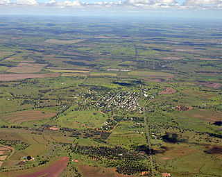
Bell is a rural town and locality in the Western Downs Region, Queensland, Australia. In the 2016 census, the locality of Bell had a population of 502 people.

Crows Nest is a rural town and locality in the Toowoomba Region, Queensland, Australia. The town is located in the Darling Downs on the New England Highway, 158 kilometres (98 mi) from the state capital, Brisbane and 43 kilometres (27 mi) from the nearby city of Toowoomba. In the 2016 census, Crows Nest had a population of 2160 people.

The Jagera people, also written Yagarr, Yaggera, and other variants, are the Australian First Nations people who speak the Yuggera language. The Yuggera language which encompasses a number of dialects was spoken by the traditional owners of the territories from Moreton Bay to the base of the Toowoomba ranges including the city of Brisbane.
Wakka Wakka, or Waka Waka, people are an Aboriginal Australian community of the state of Queensland.
Blanchview is a rural locality in the Lockyer Valley Region, Queensland, Australia. In the 2016 census, Blanchview had a population of 191 people.

Maclagan is a rural town and locality in the Toowoomba Region, Queensland, Australia. In the 2016 census the locality of Maclagan had a population of 195 people.

Boodua is a rural locality in the Toowoomba Region, Queensland, Australia. In the 2016 census Boodua had a population of 93 people.
The Dalla, also known as Jinibara, are an indigenous Australian people of southern Queensland whose tribal lands lay close to Brisbane.
The Ngandangara were an indigenous Australian people of the state of Queensland.
The Kunggara, also known as Kuritjara, are an indigenous Australian people of the southern Cape York Peninsula in Queensland.
The Djakunda were an indigenous Australian people of the state of Queensland.
The Kaiabara are an indigenous Australian people of the state of Queensland. Rather than an independent tribe, they may have been a horde of the Wakka Wakka.
John Fahy, also known as Gilburri, was an escaped Irish convict who lived with the Wakka people of the South-Burnett.
The roads that join the towns of Dalby, Toowoomba and Cooyar form a triangle that encloses some of the most fertile land on the Darling Downs in Queensland, Australia. These roads are the Warrego Highway, New England Highway and Dalby–Cooyar Road. Pechey–Maclagan Road forms a large part of a group of roads that bisect the triangle from east to west, and is also part of one of the groups of roads that bisect from south to north.