| Jefferson City Formation Stratigraphic range: Early Ordovician | |
|---|---|
| Type | Formation |
| Underlies | Cotter Dolomite |
| Overlies | Roubidoux Formation [1] |
| Lithology | |
| Primary | Dolomite |
| Other | Chert, sandstone |
| Location | |
| Region | Arkansas, Missouri |
| Country | United States |
| Type section | |
| Named for | Jefferson City, Cole County, Missouri [2] |
| Named by | Arthur Winslow |
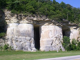
The Jefferson City Formation or Jefferson City Dolomite is a geologic formation in the Ozarks of Missouri and Arkansas. The Jefferson City is in part not differentiated from the Cotter Formation of northern Arkansas. [3] It preserves fossils dating back to the Ordovician period.

The Kimmswick Limestone is an Ordovician geologic formation in Arkansas, Illinois and Missouri. Fossils occurring in the Kimmswick include corals, bryozoans, brachiopods, conodonts, trilobites, crinoids and mollusks.

The Roubidoux Formation is a geologic formation in the Ozarks of Missouri and in Virginia. It preserves fossils dating back to the Ordovician period.
The Powell Formation or Powell Dolomite is a geologic formation in northern Arkansas, southeast Missouri and Virginia. It contains gastropod, cephalopod, and trilobite fossils dating back to the Ordovician Period.
The Cotter Formation is a geologic formation in Arkansas, Missouri, Oklahoma and in Virginia. It preserves fossils dating back to the Ordovician period.
The Fernvale Limestone is a geologic formation in Alabama, Arkansas, Illinois, Missouri, Oklahoma, and Tennessee. It preserves fossils dating back to the Ordovician period.
The Collier Shale is a geologic formation in the Ouachita Mountains of Arkansas and Oklahoma. Dating from the Late Cambrian to Early Ordovician periods, the Collier Shale is the oldest stratigraphic unit exposed in Arkansas. First described in 1892, this unit was not named until 1909 by Albert Homer Purdue in his study of the Ouachita Mountains of Arkansas. Purdue assigned the type locality to the headwaters of Collier Creek in Montgomery County, Arkansas, but did not designate a stratotype. As of 2017, a reference section for this unit has yet to be designated.
The Batesville Sandstone is a geologic formation in northern Arkansas that dates to the Chesterian Series of the late Mississippian. The base of the Batesville Sandstone, named the Hindsville Limestone Member, unconformably lies on the Moorefield Formation.

The Hale Formation is a geologic formation in northern Arkansas that dates to the Morrowan Series of the early Pennsylvanian. The Hale Formation has two named members: the Cane Hill and the Prairie Grove Members. The lower member is the Cane Hill, a primarily sandstone and shale interval that unconformably overlies the Mississippian-age Pitkin Formation. The upper member, the Prairie Grove Member, is predominately limestone and conformably underlies the Bloyd Formation.

The Bloyd Formation, or Bloyd Shale, is a geologic formation in Arkansas. It preserves fossils dating back to the Carboniferous period.

The Everton Formation is a geologic formation in northern Arkansas that dates to the middle Ordovician Period. Unconformities separate this formation from the underlying Powell Formation and the overlying St. Peter Sandstone Formation. Named for the town of Everton in Boone County, Arkansas in 1907, the Everton Formation is composed primarily of dolomite, limestone, and sandstone.
The Smithville Formation or Smithville Dolomite is a geologic formation in Arkansas. It preserves fossils dating back to the Ordovician period.
The Theodosia Formation is a geologic formation in Missouri. It preserves fossils dating back to the Ordovician period.
The St. Clair Limestone is a geologic formation in Arkansas, Indiana, Missouri, and Oklahoma. It preserves fossils dating back to the Silurian period. This high density, high magnesium dolomitic limestone was originally classified as a marble in Oklahoma due to the fact that it would hold a high polish, hence Marble City.
The Eminence Formation or Eminence Dolomite is a geologic formation in Missouri. It preserves fossils dating back to the Cambrian period.

The Potosi Formation is a geologic formation in Missouri and Indiana. It preserves fossils dating back to the Cambrian period.

The Burlington Limestone is a geologic formation in Missouri, Iowa and the Midwest region. It preserves fossils dating back to the Mississippian subperiod.
The Noix Limestone is a geologic formation in Missouri. It preserves fossils dating back to the Ordovician period.
The Rich Fountain Formation is a geologic formation in Missouri. It preserves fossils dating back to the Ordovician period.
The Joachim Dolomite is a Middle Ordovician geologic formation in Arkansas, Illinois, and Missouri. The name was first introduced in 1894 by Arthur Winslow in his study of the geology of Missouri. Winslow designated a stratotype along Plattin Creek, which was misidentified as Joachim Creek, in Jefferson County. The name was introduced into Arkansas in 1911, replacing part of the, now abandoned, Izard Limestone.
The Plattin Limestone is a Middle Ordovician geologic formation in Arkansas, Illinois, and Missouri. The name was first introduced in 1904 by Edward Oscar Ulrich in his study of the geology of Missouri. A type locality was designated at the mouth of the Plattin Creek in Jefferson County, Missouri, however a stratotype was not assigned. As of 2017, a reference section has not been designated. The name was introduced into Arkansas in 1927, replacing part of the, now abandoned, Izard Limestone.
Coordinates: 36°37′30″N90°49′50″W / 36.62500°N 90.83056°W
| | This article about a specific stratigraphic formation in the United States is a stub. You can help Wikipedia by expanding it. |