
The San Juan Islands are an archipelago in the Pacific Northwest of the United States between the U.S. state of Washington and Vancouver Island, British Columbia, Canada. The San Juan Islands are part of Washington state, and form the core of San Juan County.
San Juan County is a county located in the Salish Sea in the far northwestern corner of the U.S. state of Washington. As of the 2020 census, its population was 17,788. The county seat and only incorporated city is Friday Harbor, located on San Juan Island. The county was formed on October 31, 1873, from Whatcom County and is named for the San Juan Islands, which are in turn named for Juan Vicente de Güemes, 2nd Count of Revillagigedo, the Viceroy of New Spain.

Island County is a county located in the U.S. state of Washington. As of the 2020 census, its population was 86,857. Its county seat is Coupeville, while its largest city is Oak Harbor.

The Pig War was a confrontation in 1859 between the United States and the United Kingdom over the British–U.S. border in the San Juan Islands, between Vancouver Island and the State of Washington. The Pig War, so called because it was triggered by the shooting of a pig, is also called the Pig Episode, the Pig and Potato War, the San Juan Boundary Dispute and the Northwestern Boundary Dispute. Despite being referred to as a war, there were no casualties on either side.

Lopez Island is the third largest of the San Juan Islands and an unincorporated town in San Juan County, Washington, United States. Lopez Island is 29.81 square miles (77.2 km2) in land area. The 2000 census population was 2,177, though the population swells in the summer, as second homes, rental houses, and campsites fill up.

Sucia Island is located 2.5 miles (4.0 km) north of Orcas Island in the San Juan Islands, San Juan County, Washington, United States. It is the largest of an archipelago of ten islands including Sucia Island, Little Sucia, Ewing, Justice, Herndon, the Cluster Islands islets, and several smaller, unnamed islands. The group of islands is about 2.5 miles (4.0 km) in length and just short of a half mile wide. Sucia island is roughly the shape of a hand. The total land area of all islands is 2.74 km². The main island of Sucia Island by itself is 2.259 km². There was a permanent population of four persons as of the 2000 census, all on Sucia Island. Sucia Island State Park is a Washington State Marine Park.
Goose Island is one of the San Juan Islands in San Juan County, Washington, United States.

Manuel Quimper Benítez del Pino was a Spanish Peruvian explorer, cartographer, naval officer, and colonial official. He participated in charting the Strait of Juan de Fuca and the Sandwich Islands in the late 18th century. He was later appointed a colonial governor in his native Peru at the beginning of the fight for independence there. He retired to Spain, but was able to return to Peru where he served as a naval officer in the new republic and pursued a literary career, publishing over 20 books about his experiences before his death there in Lima.

Spieden Island is a privately owned island in the San Juan Archipelago in the U.S. state of Washington. It has a land area of 516.4 acres (209.0 ha) and no permanent resident population as of the 2000 census, although several structures are present on various parts of the island. The island was purchased by James Jannard, founder and major shareholder of Oakley, Inc. in 1997 through a shell company and is still owned by him as of 2019.
Crane Island is one of the San Juan Islands in San Juan County, Washington, United States. It lies just off the southwestern shore of Orcas Island, between it and the northwest corner of Shaw Island. Crane Island has a land area of 0.956 km². The 2000 census reported a population of 20 permanent residents.
Sheep Island or Picnic Island is one of the San Juan Islands in San Juan County, Washington, in the United States. It is a tiny island lying just off the eastern shore of West Sound, Orcas Island. Sheep Island has a land area of 6,193 square meters, with a recorded elevation of 23 feet (7.0 m).
Pearl Island is one of the San Juan Islands of San Juan County, Washington, United States. Named during the 1841 Wilkes Expedition, it lies off the western shore of San Juan Island, between it and Henry Island. Pearl Island has a land area of 0.151 km², only one family lives on this island full time.
Henry Island is one of the San Juan Islands of San Juan County, Washington, United States. It lies just off the northwest shore of San Juan Island. The small Pearl Island also lies between Henry Island and San Juan Island at its northern end. Just northwest of the northern tip of Henry Island lies Battleship Island, a State bird sanctuary. Except for Stuart Island, Henry Island is the westernmost of the San Juan Islands. It has a land area of 4.126 km² and had a 19 permanent residents as of the 2010 census.
Brown Island is a small, private island in Friday Harbor on San Juan Island, San Juan County, Washington, United States. It lies just offshore to the east-northeast of the town of Friday Harbor, Washington. The island has a land area of approximately 70 acres (28 ha) and on January 1, 2008, it had a resident full-time population of 10 people.

James Island is one of the San Juan Islands in San Juan County, Washington, United States. It lies in Rosario Strait just off the eastern shore of Decatur Island and west of the city of Anacortes. The entire island comprises James Island State Park of the Washington State Park System. It has a land area of 113 acres (46 ha) with 12,335 feet (3,760 m) of saltwater shoreline. The island has no potable water or residents. It has three different camping areas, each with at least one toilet. The camping areas combine for a total of 13 campsites and are connected by a loop trail. James Island was named by Charles Wilkes in 1841 to commemorate the naval hero Reuben James. The property was transferred from the federal government to the Washington State Parks and Recreation Commission in 1964.
Satellite Island lies in Prevost Harbor on the north side of Stuart Island in the San Juan Islands of San Juan County, Washington, United States. It has a land area of 116.42 acres (47.11 ha) and no resident population as it is a private island owned by the YMCA, which has five camping areas set up for its use. Two of the camps, Sunset Camp and Fellowship Camp, are used for overnight island trips by campers from YMCA Camp Orkila and are located on the western half of the island. Islander Camp is located on the east side of the island, and is used primarily by the Islander Teen Expedition, a kayaking trip which crosses into Canada's Gulf Islands. Mariner Camp is located on the east side of the island, near Islander Camp, and is used by the Mariner Teen Expedition, a sailing trip for teenagers.

Rosario Strait is a strait in northern Washington state, separating San Juan County and Skagit and Whatcom Counties. It extends from the Strait of Juan de Fuca about 23 kilometres (14 mi) north to the Strait of Georgia. The USGS defines its southern boundary as a line extending from Point Colville on Lopez Island to Rosario Head on Fidalgo Island, and its northern boundary as a line from Point Migley on Lummi Island to the east tip of Puffin Island and then to Point Thompson on Orcas Island. Rosario Strait runs north-south between Lopez, Decatur, Blakely, and Orcas Islands on the west, and Fidalgo, Cypress, Sinclair, and Lummi Islands on the east.
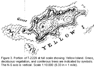
Yellow Island, one of the San Juan Islands, is an 11-acre (4.5 ha) island, located south-west of Orcas Island, and north of Shaw Island, near Jones Island State Park, in San Juan County, Washington, United States. The island is home to a wide array of flora and fauna, including over 50 species of wildflowers, bald eagles, harbor seals, black oystercatchers, and harlequin ducks. The island was purchased in 1979 by The Nature Conservancy, and is administered as a nature preserve.
Guss Island is a small island in the San Juan Islands of the U.S. state of Washington. It lies in Garrison Bay, on the northwestern shore of San Juan Island.
