
The Netherlands is both a very densely populated and a highly developed country in which transport is a key factor of the economy. Correspondingly it has a very dense and modern infrastructure, facilitating transport with road, rail, air and water networks. In its Global Competitiveness Report for 2014-2015, the World Economic Forum ranked the Dutch transport infrastructure fourth in the world.

The Republic of Suriname has a number of forms of transport. Transportation emissions are an increasing part of Suriname's contributions to climate change, as part of the Nationally Determined Contributions for the Paris Agreement, Suriname has committed to emissions controls for vehicles and increased public transit investment.

The Hague is a city and municipality of the Netherlands, situated on the west coast facing the North Sea. The Hague is the country's administrative centre and its seat of government, and while the official capital of the Netherlands is Amsterdam, The Hague has been described as the country's de facto capital. The Hague is also the capital of the province of South Holland, and the city hosts both the International Court of Justice and the International Criminal Court.

Amsterdam Zuid is a railway station situated in the borough of Amsterdam-Zuid in Amsterdam, Netherlands. For a number of years, it was named Amsterdam Zuid WTC, in reference to the neighbouring World Trade Center Amsterdam. During 2006, in conjunction with the rapid development of the area surrounding the station, the station was enlarged and the reference to the WTC was formally dropped from the name.

Den Haag Centraal is the largest railway station in the city of The Hague in South Holland, Netherlands, and with twelve tracks, the largest terminal station in the Netherlands. The railway station opened in 1973, adjacent to its predecessor: Den Haag Staatsspoor, which was subsequently demolished. It is the western terminus of the Gouda–Den Haag railway.

Haagse Bos is a rectangular neighbourhood and forest in the Haagse Hout district of The Hague, Netherlands, reaching from the old city centre in the south-west to the border of Wassenaar in the north-east. It is also one of the oldest remaining forests of the country. During World War II, the park was used by the Germans for launching V-1 and V-2 rockets.

The A4 motorway, also called Rijksweg 4, is a motorway in the Netherlands running from Amsterdam southwards to the Belgian border near Zandvliet, north of the city of Antwerp. The A4 is divided into two sections; the first and longer section runs from Amsterdam to the A15 near the city of Rotterdam, while the second section starts near Heijningen, where the A29 and the A4 meet, going to the Belgian border.

Bezuidenhout is the neighborhood southeast of the Haagse Bos neighborhood of The Hague in the Netherlands. Bezuidenhout includes the Beatrixkwartier financial area near the Central Station and streets such as Bezuidenhoutseweg, Juliana van Stolberglaan, Laan van Nieuw Oost-Indië, Prins Clauslaan, and Theresiastraat.

Den Haag HS, an abbreviation of the original name Den Haag Hollands Spoor, is the oldest train station in The Hague, South Holland, Netherlands, located on the Amsterdam–Haarlem–Rotterdam railway.

Den Haag Laan van NOI railway station is a railway station in the Netherlands, on the border between The Hague and the town of Voorburg. It is served by the Nederlandse Spoorwegen and by the RandstadRail light-rail network. The station is named after the road on which it is located, Laan van Nieuw Oost-Indië, which literally translates as New East Indies Avenue, but probably refers to a former inn called Nieuw Oosteinde.
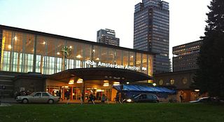
Amsterdam Amstel is a railway station in Amsterdam, Netherlands. The station opened in 1939. It is located to the southeast of Amsterdam Centraal in the borough of Amsterdam-Oost, near the Amstel river. Amsterdam Amstel is used daily by 50,000 train and metro passengers. Rail services at the station are provided by NS, the principal railway operator in the Netherlands. Metro, tram and city bus services are provided by municipal operator GVB. Regional buses are operated by Connexxion.

Groningen railway station, locally called Hoofdstation, is the main railway station in Groningen in the Province of Groningen, Netherlands. It is located on the Harlingen–Nieuweschans railway between Zuidhorn and Groningen Europapark, on the Meppel–Groningen railway as terminus after Groningen Europapark, and on the Groningen–Delfzijl railway as terminus after Groningen Noord.

Amsterdam-Zuid is a borough (stadsdeel) of Amsterdam, Netherlands. The borough was formed in 2010 as a merger of the former boroughs Oud-Zuid and Zuideramstel. The borough has almost 138,000 inhabitants (2013). With 8,500 homes per square kilometer, it is one of the most densely populated boroughs of Amsterdam. It has the highest income per household of all boroughs in Amsterdam.
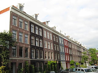
De Pijp is a neighbourhood of Amsterdam, Netherlands. It is located directly south of Amsterdam's city centre and it is part of the borough Amsterdam-Zuid, in a part of the city known as the Old South. It is served by De Pijp metro station. Most streets in De Pijp are named after Dutch painters, like Jan Steen, Frans Hals, Ruysdael and Vincent van Gogh. Diamantbuurt, Nieuwe Pijp and Oude Pijp are the three districts composing the area.
NPO FunX is a Dutch public radio station which has been on air since 3 August 2002. The station runs mainly urban music.

The bombing of the Bezuidenhout took place on 3 March 1945, when the Royal Air Force mistakenly bombed the Bezuidenhout neighbourhood in the Dutch city of The Hague. At the time, the neighbourhood was more densely populated than usual with evacuees from The Hague and Wassenaar; tens of thousands were left homeless and had to be quartered in the Eastern and Central Netherlands.

With 139,000 km of public roads, the Netherlands has one of the most dense road networks in the world – much denser than Germany and France, but still not as dense as Belgium. In 2013, 5,191 km were national roads, 7,778 km were provincial roads, and 125,230 km were municipality and other roads. Dutch roads include 3,530 km of motorways and expressways, and with a motorway density of 64 kilometres per 1,000 km2, the country also has one of the densest motorway networks in the world. In Dutch a motorway is called "autosnelweg" or simply "snelweg"; other expressways are just called "autoweg". According to a 2004 estimate, some 12,500 km of road remain as yet unpaved.
The following is a timeline of the history of the municipality of The Hague, Netherlands,
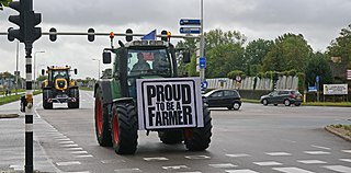
The Dutch farmers' protests are a series of demonstrations by Dutch livestock farmers, characterised by the use of tractors to block roads, and occupy public spaces. The protests were initially triggered in October 2019 by a government proposal to halve the country's livestock in an attempt to limit agricultural pollution in the Netherlands, but protesting farmers have frequently told media that they are motivated by a perceived lack of respect for their profession by the Dutch populace, media and politicians. The protests combined several action groups and an amalgamation of larger goals, which included less government regulation for farmers, more air time for pro-farmer sentiments, and more policy to punish Shell and Tata Steel for their part in the emission crisis.

The 1989–1990 Dutch farmers' protests, for want of an unambiguous official name also referred to as the Farmers' Revolt, was a series of protests by Dutch farmers of arable land. Starting locally in February–March 1989 and culminating in nationwide demonstrations in February–March 1990, the protests were a response to changes in government agricultural policy beginning in the mid-1980s.
