Jonesville, South Carolina

Last updated

Jonesville, South Carolina
City
SCMap-doton-Jonesville.PNG
Location of Jonesville, South Carolina
Coordinates: 34°50′8″N81°40′54″W / 34.83556°N 81.68167°W / 34.83556; -81.68167
Country United States
State South Carolina
County Union
Area
[1]
  Total1.02 sq mi (2.65 km2)
  Land1.01 sq mi (2.63 km2)
  Water0.01 sq mi (0.02 km2)
Elevation
[2]
686 ft (209 m)
Population
 (2020) [3]
  Total852
  Density839.41/sq mi (324.21/km2)
Time zone UTC-5 (Eastern (EST))
  Summer (DST) UTC-4 (EDT)
ZIP codes
29353, 29395
Area code 864
FIPS code 45-37330 [4]
GNIS feature ID1246204 [2]
Website townofjonesvillesc.org

Jonesville is a town in Union County, South Carolina, United States. The population was 911 at the 2010 United States Census.

Contents

History

The McWhirter House and Means House are listed on the National Register of Historic Places. [5]

Geography

Jonesville is located at 34°50′8″N81°40′54″W / 34.83556°N 81.68167°W / 34.83556; -81.68167 (34.835689, -81.681712). [6]

According to the United States Census Bureau, the town has a total area of 1.0 square mile (2.6 km2), of which, 1.0 square mile (2.6 km2) of it is land and 0.97% is water.

Demographics

Historical population
CensusPop.Note
1880 266
1890 2867.5%
1900 50877.6%
1910 96990.7%
1920 1,20924.8%
1930 1,153−4.6%
1940 1,1822.5%
1950 1,34513.8%
1960 1,4397.0%
1970 1,4470.6%
1980 1,201−17.0%
1990 1,2050.3%
2000 982−18.5%
2010 911−7.2%
2020 852−6.5%
U.S. Decennial Census [7] [3]

As of the census [4] of 2000, there were 982 people, 444 households, and 264 families residing in the town. The population density was 965.6 inhabitants per square mile (372.8/km2). There were 497 housing units at an average density of 488.7 per square mile (188.7/km2). The racial makeup of the town was 65.07% White, 32.79% African American, 0.10% Native American, 0.20% Pacific Islander, 1.02% from other races, and 0.81% from two or more races. Hispanic or Latino of any race were 1.53% of the population.

There were 444 households, out of which 25.2% had children under the age of 18 living with them, 35.8% were married couples living together, 18.5% had a female householder with no husband present, and 40.5% were non-families. 36.7% of all households were made up of individuals, and 20.7% had someone living alone who was 65 years of age or older. The average household size was 2.21 and the average family size was 2.88.

In the town, the population was spread out, with 22.6% under the age of 18, 6.8% from 18 to 24, 26.5% from 25 to 44, 23.8% from 45 to 64, and 20.3% who were 65 years of age or older. The median age was 40 years. For every 100 females, there were 92.2 males. For every 100 females age 18 and over, there were 85.8 males.

The median income for a household in the town was $22,273, and the median income for a family was $31,458. Males had a median income of $24,583 versus $19,643 for females. The per capita income for the town was $13,116. About 9.5% of families and 12.5% of the population were below the poverty line, including 15.9% of those under age 18 and 14.9% of those age 65 or over.

Related Research Articles

<span class="mw-page-title-main">Saline County, Arkansas</span> County in Arkansas, United States

Saline County is located in the U.S. state of Arkansas. As of the 2020 census, the population was 123,416. Its county seat and largest city is Benton. Saline County was formed on November 2, 1835, and named for the salt water (brine) springs in the area, despite a differing pronunciation from saline. Until November 2014, it was an alcohol prohibition or dry county.

<span class="mw-page-title-main">Jonesville, Indiana</span> Town in Indiana, United States

Jonesville is a town in Wayne Township, Bartholomew County, in the U.S. state of Indiana. The population was 177 at the 2010 census. It is part of the Columbus, Indiana metropolitan statistical area.

<span class="mw-page-title-main">Slater, Iowa</span> City in Iowa, United States

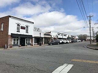
Slater is a city in Story County, Iowa, United States. The population was 1,543 at the time of the 2020 census.

<span class="mw-page-title-main">Jonesville, Louisiana</span> Town in Louisiana, United States

Jonesville is the largest town in Catahoula Parish, Louisiana, United States, at the confluence of the Ouachita, Tensas, and Little rivers. The three rivers become the Black River at Jonesville.

<span class="mw-page-title-main">Clayton, Louisiana</span> Town in Louisiana, United States

Clayton is a town in northern Concordia Parish, Louisiana, United States. The population was 711 at the 2010 census. Cotton is a principal commodity in the area. Clayton is located on the Tensas River, important for fishing and boating, promoted through a U.S. Army Corps of Engineers-maintained boat launch. The Tensas River merges with the Black River in Jonesville in Catahoula Parish.

<span class="mw-page-title-main">Surrey Township, Michigan</span> Civil township in Michigan, United States

Surrey Township is a civil township of Clare County in the U.S. state of Michigan. The population was 3,635 at the 2020 census.

Carmel Township is a civil township of Eaton County in the U.S. state of Michigan. The population was 2,839 as of the 2020 census.

Eaton Township is a civil township of Eaton County in the U.S. state of Michigan. The population was 4,007 at the 2020 United States Census.

<span class="mw-page-title-main">Baywood-Los Osos, California</span> Unincorporated community in California, United States

Baywood-Los Osos is an unincorporated community in western San Luis Obispo County, California. The population was 14,351 in the 2000 census. It includes the communities of Los Osos, which is located near Morro Bay, Baywood Park, and the former community of Cuesta-by-the-Sea.

<span class="mw-page-title-main">Jonesville, Michigan</span> City in Michigan, United States

Jonesville is a city in Hillsdale County in the U.S. state of Michigan. The population was 2,176 at the 2020 census.

<span class="mw-page-title-main">Scipio Township, Michigan</span> Civil township in Michigan, United States

Scipio Township is a civil township of Hillsdale County in the U.S. state of Michigan. The population was 1,902 at the 2020 census.

<span class="mw-page-title-main">Fallon, Montana</span> CDP in Montana, United States

Fallon is an unincorporated small town in Prairie County, Montana, United States. The population was 164 at the 2010 census., although, as the town name has been co-opted for use by the United States Census Bureau as a census-designated place, this figure may include persons living well outside the town's limits. Fallon's current mayor is Colin Armould.

<span class="mw-page-title-main">Marshville, North Carolina</span> Town in North Carolina, United States

Marshville is a town in Union County, North Carolina, United States. Its population was 2,402 at the 2010 census. Marshville is known as the birthplace of country music singer Randy Travis.

<span class="mw-page-title-main">Elder Township, Cambria County, Pennsylvania</span> Township in Pennsylvania, United States

Elder Township is a township in Cambria County, Pennsylvania, United States, about 24 miles (39 km) northwest of Altoona. As of the 2010 census, the township had a population of 1,038. It is part of the Johnstown, Pennsylvania Metropolitan Statistical Area.

<span class="mw-page-title-main">Jonesville, Virginia</span> Town in southwest Virginia, US

Jonesville is a town in and the county seat of Lee County, Virginia, United States. The population was 1,034 at the 2010 census.

<span class="mw-page-title-main">Sylvester, West Virginia</span> Town in West Virginia, United States

Sylvester is a town in Boone County, West Virginia, United States, along the Big Coal River. The population was 166 at the 2020 census. Sylvester was incorporated on April 11, 1952, by the Boone County Circuit Court. Sylvester bears the name of a family of settlers.

<span class="mw-page-title-main">Grantsville, West Virginia</span> Town in West Virginia, United States

Grantsville is a town in Calhoun County, West Virginia, United States. The population was 482 at the 2020 census. It is the county seat of Calhoun County. The town was established along the Little Kanawha River in 1865 and named for Ulysses S. Grant. Grantsville is home to Wayne Underwood Park, which includes a .25-mile-long (0.40 km) walking trail, and to the annual West Virginia Wood Festival.

<span class="mw-page-title-main">Gauley Bridge, West Virginia</span> Town in West Virginia, United States

Gauley Bridge is a town in Fayette County, West Virginia, United States. The population was 614 at the 2010 census. The Kanawha River is formed at Gauley Bridge by the confluence of the New and Gauley Rivers. Two miles to the southwest of Gauley Bridge, in Glen Ferris, is Kanawha Falls, a popular stopping point on Midland Trail Scenic Highway.

<span class="mw-page-title-main">New Haven, West Virginia</span> Town in West Virginia, United States

New Haven is a town in Mason County, West Virginia, United States, along the Ohio River. The population was 1,485 at the 2020 census. It is part of the Point Pleasant, WV–OH Micropolitan Statistical Area.

<span class="mw-page-title-main">Cairo, West Virginia</span> Town in West Virginia, United States

Cairo is a town in Ritchie County, West Virginia, United States, along West Virginia Route 31, the North Fork of the Hughes River, and the North Bend Rail Trail. The population was 174 at the 2020 census.

References

  1. "ArcGIS REST Services Directory". United States Census Bureau. Retrieved October 15, 2022.
  2. 1 2 U.S. Geological Survey Geographic Names Information System: Jonesville, South Carolina
  3. 1 2 "Census Population API". United States Census Bureau. Retrieved October 15, 2022.
  4. 1 2 "U.S. Census website". United States Census Bureau . Retrieved January 31, 2008.
  5. "National Register Information System". National Register of Historic Places . National Park Service. July 9, 2010.
  6. "US Gazetteer files: 2010, 2000, and 1990". United States Census Bureau. February 12, 2011. Retrieved April 23, 2011.
  7. "Census of Population and Housing". Census.gov. Retrieved June 4, 2015.