Related Research Articles

Hawthorne is a city in Alachua County, Florida, United States, incorporated in 1881. Indigenous peoples of the Americas had been living in the area since around 100 CE; Hawthorne grew around their trading trails. Throughout its history, Hawthorne has been known for its agriculture, railroad, and rural lifestyle. Hawthorne's population was 1,478 at the 2020 census, with an area of 7.38 sq mi (19.1 km2).
Fruit Cove is a census-designated place (CDP) in St. Johns County, Florida, United States. The population was 16,077 at the 2000 census. It is located in the community of St. Johns.

John Bartram was an American botanist, horticulturist, and explorer, based in Philadelphia, Pennsylvania, for most of his career. Swedish botanist and taxonomist Carl Linnaeus said he was the "greatest natural botanist in the world." Bartram corresponded with and shared North American plants and seeds with a variety of scientists in England and Europe.

William Bartram was an American botanist, ornithologist, natural historian and explorer. Bartram was the author of an acclaimed book, now known by the shortened title Bartram's Travels, which chronicled his explorations of the southern British colonies in North America from 1773 to 1777. Bartram has been described as "the first naturalist who penetrated the dense tropical forests of Florida".

Amelia Island is a part of the Sea Islands chain that stretches along the East Coast of the United States from South Carolina to Florida; it is the southernmost of the Sea Islands, and the northernmost of the barrier islands on Florida's Atlantic coast. Lying in Nassau County, Florida, it is 13 miles (21 km) long and approximately 4 miles (6.4 km) wide at its widest point. The communities of Fernandina Beach, Amelia City, and American Beach are located on the island.

The history of Washington, D.C., is tied to its role as the capital of the United States. The site of the District of Columbia along the Potomac River was first selected by President George Washington. The city came under attack during the War of 1812 in an episode known as the Burning of Washington. Upon the government's return to the capital, it had to manage the reconstruction of numerous public buildings, including the White House and the United States Capitol. The McMillan Plan of 1901 helped restore and beautify the downtown core area, including establishing the National Mall, along with numerous monuments and museums.

Mount Olivet Cemetery is a historic rural cemetery located at 1300 Bladensburg Road, NE in Washington, D.C. It is maintained by the Roman Catholic Archdiocese of Washington. The largest Catholic burial ground in the District of Columbia, it was one of the first in the city to be racially integrated.
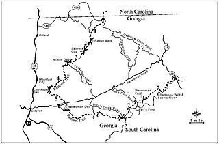
The Bartram Trail follows the approximate route of 18th-century naturalist William Bartram’s southern journey from March 1773 to January 1777. Bartram explored much of the territory which is now the states of North and South Carolina, Georgia, Florida, Alabama, Mississippi, Louisiana and Tennessee.

Switzerland is an unincorporated community in northwest St. Johns County, Florida, United States, adjacent to Fruit Cove.
Julington Creek Plantation is an unincorporated community in the larger community of St. Johns, St. Johns County, Florida, United States. It consists of several large neighborhoods, and is located along Race Track Road east of State Road 13, across from Fruit Cove.
Mandarin is a neighborhood located in the southernmost portion of Jacksonville, in Duval County, Florida, United States. It is located on the eastern banks of the St. Johns River, across from Orange Park. It's a short drive south of Jacksonville's city center, and is bordered by Beauclerc to the north, Julington Creek to the south and St. John's River to the west.

The Original Town of Fernandina Historic Site, also known as "Old Town", is a historic site in Fernandina Beach, Florida, located on Amelia Island. It is roughly bounded by Towngate Street, Bosque Bello Cemetery, Nassau, Marine, and Ladies Streets. On January 29, 1990, it was added to the U.S. National Register of Historic Places as a historic site. Lying north of the Fernandina Beach Historic District, it is accessible from North 14th Street.
St. Johns is an unincorporated community in northwest St. Johns County, Florida, United States and a suburb of Jacksonville. The population as of the 2000 census was 18,063, though considerable growth has taken place in the past ten years. As of 2016, the population is estimated to be approximately 86,400 people. It is located in the Jacksonville metropolitan area, and lies approximately halfway between downtown Jacksonville and downtown St. Augustine.

Black Creek is a tributary of the St. Johns River in Clay County, Florida. It is formed by the confluence of North Fork Black Creek and South Fork Black Creek. North Fork Black Creek originates as an outflow from Kingsley Lake and flows north and then southeast, meeting South Fork Black Creek on the east side of MIddleburg. North Fork Black Creek has Yellow Water Creek as its main tributary. South Fork Black Creek originates in a chain of lakes about four miles south of Kingsley Lake, with Ates Creek, Bull Creek, and Greens Creek as its main tributaries. Both forks are fed by areas of wetlands and numerous small streams.

St. Johns County School District (SJCSD) is the public school district for St. Johns County, Florida.

The L'Enfant Plan for the city of Washington is the urban plan developed in 1791 by Major Pierre Charles L'Enfant for George Washington, the first president of the United States.
The Julington-Durbin Preserve is a 2,031-acre nature preserve operated by the St. Johns River Water Management District in Duval County, Florida. The preserve shares the name of the two creeks that border the preserve and connect to the St. Johns River. Julington Creek is on the north side of the preserve, and Durbin Creek is to the south. The preserve has three designated hiking trails. Recreational activities include picnicking, horseback riding, bicycling, and hiking.

Fort Picolata was an 18th-century Spanish fort on the east bank of the St. Johns River, about eighteen miles from St. Augustine, the capital of Spanish Florida. Lying on the old trail to the Spanish province of Apalachee in western Florida, Fort Picolata and its sister outpost, Fort San Francisco de Pupo, controlled all traffic at the ferry crossing where the river narrows considerably, a natural pass called "Salamatoto" by the Indians. The first defense works at the site, built soon after 1700 as an outpost of the military defensive network of St. Augustine, were little more than a sentry box surrounded by a palisade.
References
- ↑ "Julington Creek". Geographic Names Information System . United States Geological Survey, United States Department of the Interior . Retrieved September 9, 2020.
- ↑ "The National Gazetteer of the United States of America: Florida 1992". The Survey. June 13, 1992 – via Google Books.
- ↑ McCarthy, Kevin M. (June 13, 2008). St. Johns River Guidebook. Pineapple Press Inc. ISBN 9781561644353 – via Google Books.
- ↑ Claiborne, Young. Cruising Guide to Eastern Florida: 5th Edition. Pelican Publishing. ISBN 9781455603152 – via Google Books.
- ↑ Anderson, Lorraine; Edwards, Thomas S. (June 13, 2002). At Home on this Earth: Two Centuries of U.S. Women's Nature Writing. UPNE. ISBN 9781584651932 – via Google Books.
- ↑ Williams, John Lee (June 17, 1837). "The Territory of Florida: Or Sketches of the Topography, Civil and Natural History, of the Country, the Climate, and the Indian Tribes, from the First Discovery to the Present Time". A. T. Goodrich – via Google Books.
- ↑ "The Florida Historical Quarterly". Florida Historical Society. June 17, 1956 – via Google Books.
- 1 2 Spornick, Charles D.; Cattier, Alan; Greene, Robert J. (June 13, 2003). An Outdoor Guide to Bartram's Travels. University of Georgia Press. ISBN 9780820324388 – via Google Books.
- ↑ Congress, United States (June 13, 1860). "American State Papers: Documents, Legislative and Executive, of the Congress of the United States". Gales and Seaton – via Google Books.