
Canyonlands National Park is an American national park located in southeastern Utah near the town of Moab. The park preserves a colorful landscape eroded into numerous canyons, mesas, and buttes by the Colorado River, the Green River, and their respective tributaries. Legislation creating the park was signed into law by President Lyndon Johnson on September 12, 1964.

The exposed geology of the Canyonlands area is complex and diverse; 12 formations are exposed in Canyonlands National Park that range in age from Pennsylvanian to Cretaceous. The oldest and perhaps most interesting was created from evaporites deposited from evaporating seawater. Various fossil-rich limestones, sandstones, and shales were deposited by advancing and retreating warm shallow seas through much of the remaining Paleozoic.

Westwater Canyon is a canyon located on the Colorado River in Eastern Utah between the Utah/Colorado state line and Cisco, Utah. The inner gorge of the canyon is made up of black Precambrian rock and contains class III and IV rapids which are sought after by whitewater enthusiasts. The most notable rapid, called "Skull", is the most significant.

Elephant Butte is a 5,653-ft summit in Grand County, Utah. It is located within Arches National Park, and is the highest point in the park. Like many of the rock formations in the park, Elephant Butte is composed of Entrada Sandstone. Elephant Butte is a flat-topped cap surrounded by numerous towers and fins including Parade of Elephants. Double Arch is also a natural feature of Elephant Butte and was used as a backdrop for the opening scene of Indiana Jones and the Last Crusade. Precipitation runoff from Elephant Butte drains east into the nearby Colorado River. The first ascent was made September 8, 1953, by Alex Cresswell and Fred Ayres.

Druid Arch is a 150-ft tall Cedar Mesa Sandstone arch located within the Needles District of Canyonlands National Park, in San Juan County, Utah. It is situated at the head of Elephant Canyon, and precipitation runoff from Druid Arch drains north into the nearby Colorado River via Elephant Canyon. Druid Arch is one of the most popular hiking destinations in the Needles district. A 5.4 mile hike to Druid Arch starts at the Elephant Hill Trailhead, and the final quarter-mile is steep with some scrambling and one ladder. The name comes from its resemblance to the Stonehenge monument in England, which is believed to be a Druid temple. This feature's name was officially adopted in 1963 by the U.S. Board on Geographic Names.

Angel Arch is the largest natural arch located within Canyonlands National Park, in San Juan County, Utah. Some consider it the most beautiful and spectacular arch in the park, if not the entire canyon country. It is situated in a side canyon of Salt Creek Canyon, in the Needles District of the park. Precipitation runoff from Angel Arch drains north into the nearby Colorado River via Salt Creek. A 29-mile round-trip hike to Angel Arch leads to a viewpoint, and an additional 0.75-mile trail scrambles up into the arch opening. The arch's descriptive name comes from its resemblance to an angel with wings folded, and standing with its back to the arch opening. This feature's name was officially adopted in 1963 by the U.S. Board on Geographic Names. The first ascent was made in June 1993, by John Markel and Kevin Chase.

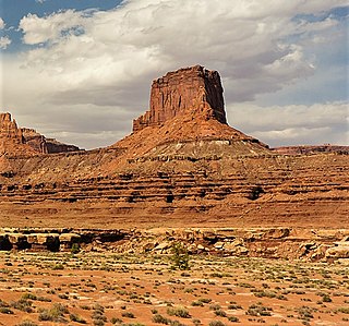
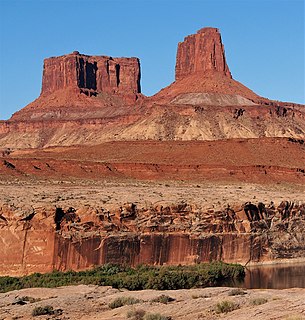
Monster Tower is a 600-foot (180-meter) tall sandstone tower located in the Island in the Sky District of Canyonlands National Park, in San Juan County, Utah. It is situated 300 feet southeast of Washer Woman, which is a towering arch nearly as high. Washer Woman is so named because the feature gives the appearance of a woman bent over a washtub. Monster and Washer Woman are an eroded fin composed of Wingate Sandstone, which is the remains of wind-borne sand dunes deposited approximately 200 million years ago in the Late Triassic. The nearest higher neighbor is Aztec Butte, 2 mi (3.2 km) to the west-northwest, Airport Tower is set 1.6 mi (2.6 km) to the east, and Mesa Arch is situated 1.5 mi (2.4 km) to the west. A short hike to Mesa Arch provides the easiest view of Monster Tower. Access to the tower is via the four-wheel drive White Rim Road, which is the other way to see Monster. The top of this geological formation rises 1,400 feet above the road in approximately one mile. Precipitation runoff from Monster Tower drains southeast into the nearby Colorado River via Buck Canyon.

Candlestick Tower is a 450-foot (140-meter) tall sandstone butte located in the Island in the Sky District of Canyonlands National Park, in San Juan County, Utah. Its descriptive name is from its resemblance to a candlestick. Candlestick Tower is composed of Wingate Sandstone, which is the remains of wind-borne sand dunes deposited approximately 200 million years ago in the Late Triassic. The nearest higher neighbor is Shaft Benchmark, 2 mi (3.2 km) to the east, Upheaval Dome is set 3 mi (4.8 km) to the north, and the Green River Overlook is situated 2.5 mi (4.0 km) to the east. Access to the tower is via the four-wheel drive White Rim Road. Candlestick is situated north of Soda Springs Basin and south of Holeman Spring Basin, and the top of this geological formation rises 1,400 feet above the White Rim Road in approximately one mile. Precipitation runoff from Candlestick Tower drains into the nearby Green River via these two basins.

Washer Woman is a 500-foot (150-meter) tall sandstone arch and tower located in the Island in the Sky District of Canyonlands National Park, in San Juan County, Utah. It is situated 300 feet northwest of the slightly higher Monster Tower. Washer Woman is so named because the feature gives the appearance of a washerwoman bent over a washtub. This geographical feature's name was officially adopted in 1986 by the U.S. Board on Geographic Names after previously having similar names such as Washer-Woman Arch and The Washer Woman. Washer Woman and Monster Tower are an eroded fin composed of Wingate Sandstone, which is the remains of wind-borne sand dunes deposited approximately 200 million years ago in the Late Triassic. Airport Tower is set 1.6 mi (2.6 km) to the east, and Mesa Arch is situated 1.5 mi (2.4 km) to the west. A short hike to Mesa Arch provides the easiest view of Washer Woman. Access to this formation is via the four-wheel drive White Rim Road, which is the other option to see it. The top of this geological formation rises 1,300 feet above the road in approximately one mile. Precipitation runoff from Washer Woman drains southeast into the nearby Colorado River via Buck Canyon.

Owl Rock is a 6,547-foot elevation sandstone summit located south of Monument Valley, in northeast Arizona. It is situated 7 miles (11 km) north of Kayenta on Navajo Nation land, and can be seen from Highway 163 perched on the east edge of Tyende Mesa, where it towers 1,000 feet above the surrounding terrain. The descriptive name stems from its uncanny resemblance to an owl when viewed from the east. Its nearest higher neighbor is Agathla Peak, 1.4 miles (2.3 km) to the east-northeast, on the opposite side of this highway. Precipitation runoff from this feature drains into El Capitan Wash, which is part of the San Juan River drainage basin. The first ascent of Owl Rock was made in April 1966 by Fred Beckey and Harvey Carter by climbing cracks on the west face, and then bolting up a smooth south nose to the summit. They employed 20 pitons and 14 bolts on this route called Warpath. This Owl Rock is not to be confused with another located in Arches National Park in Utah.

The Castle is a 6,387-foot (1,947-meter) elevation summit located in Capitol Reef National Park, in Wayne County of Utah, United States. This iconic landmark is situated 0.5 mi (0.80 km) immediately north of the park's visitor center, towering nearly 800 feet above the center and Highway 24. Precipitation runoff from this feature is drained by tributaries of the Fremont River.

Chimney Rock is a 6,420-foot (1,960-meter) elevation summit located in Capitol Reef National Park, in Wayne County of Utah, United States. This landmark is situated 2.5 mi (4.0 km) northwest of the park's visitor center, towering over 300 feet above Highway 24. Chimney Rock is also 2.5 mi (4.0 km) northwest of another of the park's landmarks, The Castle. Precipitation runoff from this feature ends up in the Colorado River drainage basin. The Chimney Rock Trail is a 3.5-mile loop trail that takes hikers to a view of Chimney Rock from above Mummy Cliffs.
Airport Tower is a 700-foot (210-meter) tall sandstone butte located in the Island in the Sky District of Canyonlands National Park, in San Juan County, Utah. It is situated 1.64 mile east of Washer Woman, which is a towering arch similar in height. Each are composed of Wingate Sandstone, which is the remains of wind-borne sand dunes deposited approximately 200 million years ago in the Late Triassic. The nearest higher neighbor is Monster Tower, 1.6 mi (2.6 km) to the west, and Mesa Arch is situated 3.2 mi (5.1 km) to the west. A short hike to Mesa Arch provides the easiest view of Airport Tower. Access to this tower is via the four-wheel drive White Rim Road, which is another option to see Airport Tower. The top of this geological formation rises 1,400 feet above the road in less than one mile. Precipitation runoff from Airport Tower drains southeast into the nearby Colorado River via Buck and Lathrop Canyons. This geographical feature's name was officially adopted in 1986 by the U.S. Board on Geographic Names. It was so named because the rock formation resembles the appearance of an airport control tower.

Zeus and Moses, variant Moses and Zeus, is a 500-foot (150-meter) tall sandstone formation located in the Island in the Sky District of Canyonlands National Park, in San Juan County, Utah. These rock towers' names refer to Zeus, god of Roman mythology, and Moses, an important prophet of several religions. Zeus and Moses is composed of Wingate Sandstone, which is the remains of wind-borne sand dunes deposited approximately 200 million years ago in the Late Triassic. This formation is situated in Taylor Canyon, 3 mi (4.8 km) north-northeast of Upheaval Dome. Access to the towers is via the four-wheel drive White Rim Road, and a spur road into Taylor Canyon. The top of this geological formation rises 900 feet above the canyon floor at road's end, approximately one-half mile away. Precipitation runoff from Zeus and Moses drains into the nearby Green River via Taylor Canyon.

Aztec Butte is a 6,312-foot (1,924-meter) elevation sandstone summit located in the Island in the Sky District of Canyonlands National Park, in San Juan County, Utah. Aztec Butte is composed of white cross-bedded Navajo Sandstone, which is the remains of wind-borne sand dunes deposited approximately 170 million years ago during the Jurassic Period. It resembles the Pyramid of the Sun in Mexico, which was built by the Aztecs. Ancestral Puebloans traveled to the Island in the Sky area to hunt and gather seeds, then stored their food in stone granaries near the top of Aztec Butte. These well-preserved granaries date to AD 1200–1300. A half-mile hiking trail through flat grassland, followed by a quarter-mile scramble with 200-feet gain, leads to the top of the butte and the granaries. The trailhead is located alongside the road to Upheaval Dome. In addition to Upheaval Dome, other nearby attractions include Mesa Arch which is situated less than 1 mi (1.6 km) to the southeast, Muffin Butte to the south, Green River Overlook to the southwest, and Trail Canyon to the north. Precipitation runoff from Aztec Butte drains to the Green River.

Eph Hanks Tower is a 6,540-foot (1,990-meter) elevation summit located in Capitol Reef National Park, in Wayne County of Utah, United States. This landmark is situated 8 mi (13 km) southeast of the park's visitor center, 3.5 mi (5.6 km) south-southeast of Ferns Nipple, and 1.4 mi (2.3 km) south-southwest of Golden Throne, at the mouth of Capitol Gorge where the Capitol Reef Scenic Drive road ends. It towers 900 feet above the picnic area below its north aspect. Precipitation runoff from this feature is drained by Capitol Wash and Pleasant Creek, a tributary of the Fremont River, which in turn is within the Colorado River drainage basin. This geological feature is named after Ephraim Knowlton Hanks (1826–1896), a Mormon pioneer and first permanent settler in the Capitol Reef area, who with his family homesteaded in the Pleasant Creek area of Capitol Reef in 1881. Ephraim Hank's Floral Ranch on Pleasant Creek supposedly offered a safe retreat for polygamists along the Mormon underground railroad.
Buttes of the Cross is two sandstone summits located in the northern reach of Glen Canyon National Recreation Area, in Wayne County of Utah, United States. The larger and higher south butte reaches an elevation of 5,642 feet, whereas the north butte rises to 5,569 feet, with approximately 0.6 mile separation between them. When viewed from the north-northeast near Labyrinth Canyon, they align to form the shape of a cross, creating the appearance of a single butte. The name "Butte of the Cross" was first applied by John Wesley Powell during the Powell Geographic Expedition of 1869. A few miles further down the Green River, Powell finds that this geographical feature is two buttes when viewed from the east, so it was renamed Buttes of the Cross. Buttes of the Cross towers over 1,400 feet above its surrounding terrain. It is situated 6.8 miles west of Candlestick Tower, and one-half mile outside the boundary of Canyonlands National Park.

Ekker Butte is a 6,260-foot (1,910-meter) elevation summit located in the northern reach of Glen Canyon National Recreation Area, in Wayne County of Utah, United States. It is situated seven miles southeast of Buttes of the Cross, six miles northeast of Elaterite Butte, and less than two miles outside the boundary of Canyonlands National Park, where it towers over 1,400 feet above the surrounding terrain. Distant views of this remote butte can be seen from the Grand View Point and Green River Overlooks at Island in the Sky of Canyonlands National Park. This geological landmark is named for the pioneering Art Ekker family which operated the nearby Robbers Roost Ranch and grazed cattle on land adjacent to the nearby Maze. Arthur Benjamin Ekker (1911–1978) took Robert Redford on a tour of nearby Robbers Roost, the hideout of outlaw Butch Cassidy and the Wild Bunch.

Elaterite Butte is a 6,552-foot (1,997-meter) elevation summit located in The Maze District of Canyonlands National Park, in Wayne County, Utah. Elaterite Butte is situated 6 mi (9.7 km) southwest of Ekker Butte, and the Maze Overlook is situated 2.5 mi (4.0 km) to the northeast. Elaterite Butte is composed of hard, fine-grained Wingate Sandstone, which is the remains of wind-borne sand dunes deposited approximately 200 million years ago in the Late Triassic. This Wingate sandstone overlays a 432-foot thick layer of the softer Chinle Formation. The top of this geological formation rises over 1,400 feet above Elaterite Basin. The butte and basin are named for elaterite, which is a dark brown, tar-like, elastic mineral resin that seeps from parts of the nearby White Rim Sandstone. Access to the remote butte is via a four-wheel drive road in Elaterite Basin. Precipitation runoff from Elaterite Butte drains into the nearby Green River, which in turn is within the Colorado River drainage basin.

Chip and Dale Towers are two 300-foot (91-meter) tall sandstone towers located in the Island in the Sky District of Canyonlands National Park, in San Juan County, Utah. Dale Tower rises to an elevation of 5,620 feet, whereas the lower Chip Tower is 5,420-feet. Airport Tower is set 2.5 mi (4.0 km) to the southwest, and Dead Horse Point State Park overlook is situated 4.5 mi (7.2 km) to the north-northeast. Chip and Dale Towers are an eroded fin composed of hard, fine-grained Wingate Sandstone, which is the remains of wind-borne sand dunes deposited approximately 200 million years ago in the Late Triassic. This Wingate Sandstone overlays a softer layer of the Chinle Formation. Access to the towers is via the four-wheel drive White Rim Road, and a scramble to reach the base. The top of the towers rise over 1,000 feet above the road in approximately one-half mile. Precipitation runoff from Chip and Dale Towers drains east to the nearby Colorado River.


