Kagisano Local Municipality

Last updated
Kagisano Local Municipality
Map of the North West with Kagisano highlighted.svg
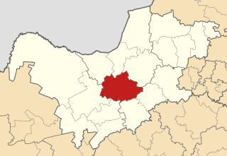
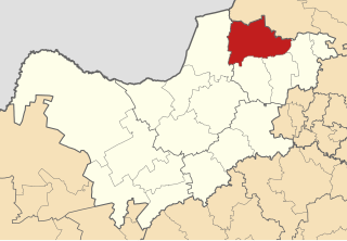
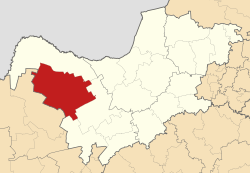
Location in the North West
Country South Africa
Province North West
District Dr Ruth Segomotsi Mompati District
Seat Ganyesa
Area
  Total11,354 km2 (4,384 sq mi)
Population
 (2001) [1]
  Total88,780
  Density7.8/km2 (20/sq mi)
Time zone UTC+2 (SAST)
Municipal codeNW391

Kagisano Local Municipality was a local municipality in Dr Ruth Segomotsi Mompati District Municipality, North West Province, South Africa, until the election of 18 May 2011, when it was merged with the Molopo Local Municipality to form the Kagisano-Molopo Local Municipality.

In South Africa, a local municipality or Category B municipality is a type of municipality that serves as the third, and most local, tier of local government. Each district municipality is divided into a number of local municipalities, and responsibility for municipal affairs is divided between the district and local municipalities. There are 226 local municipalities in South Africa.

Dr Ruth Segomotsi Mompati District Municipality District municipality in North West, South Africa

Dr Ruth Segomotsi Mompati District Municipality is one of the 4 districts of North West province of South Africa. The seat of Mompati District is Vryburg. The majority of its 439 637 people speak Setswana. The district code is DC39. It is South Africa's largest beef producing district, with Hereford cattle the most popular. It is sometimes called "the Texas of South Africa". Maize and peanuts are important crops produced in the district. The district was renamed after the mayor of Vryburg.

South Africa Republic in the southernmost part of Africa

South Africa, officially the Republic of South Africa (RSA), is the southernmost country in Africa. It is bounded to the south by 2,798 kilometres (1,739 mi) of coastline of Southern Africa stretching along the South Atlantic and Indian Oceans; to the north by the neighbouring countries of Namibia, Botswana, and Zimbabwe; and to the east and northeast by Mozambique and Eswatini (Swaziland); and it surrounds the enclaved country of Lesotho. South Africa is the largest country in Southern Africa and the 25th-largest country in the world by land area and, with over 57 million people, is the world's 24th-most populous nation. It is the southernmost country on the mainland of the Old World or the Eastern Hemisphere. About 80 percent of South Africans are of Bantu ancestry, divided among a variety of ethnic groups speaking different African languages, nine of which have official status. The remaining population consists of Africa's largest communities of European, Asian (Indian), and multiracial (Coloured) ancestry.

Main places

The 2001 census divided the municipality into the following main places: [2]

South African National Census of 2001

The National Census of 2001 was the 2nd comprehensive national census of the Republic of South Africa, or Post-Apartheid South Africa. It undertook to enumerate every person present in South Africa on the census night between 9–10 October 2001 at a cost of R987,000,000.

PlaceCodeArea (km2)PopulationMost spoken language
Batlharo Ba Lotlhware 61101 8,084.8059,209 Tswana
Louwna 61103 0.60235Tswana
Morokweng 61104 1,584.8626,694Tswana
Piet Plessis 61105 32.091,055Tswana
Remainder of the municipality 61102 4,986.079,193Tswana

Related Research Articles

North West (South African province) Province of South Africa

North West is a province of South Africa. Its capital is Mahikeng. The province is located to the west of the major population centre of Gauteng.

Tswaing Local Municipality Local municipality in North West, South Africa

Tswaing Local Municipality is a local Municipality consisting of the towns of Delareyville, Sannieshof and Ottosdal in the Central District Municipality situated in the North West Province of South Africa.

Zululand District Municipality District municipality in KwaZulu-Natal, South Africa

Zululand is one of the 11 district municipalities ("districts") of KwaZulu-Natal province. The seat of Zululand is Ulundi. The majority of its 803,575 people speak IsiZulu. The district code is DC26. It is part of a larger historical area also known as Zululand.

Nkangala District Municipality District municipality in Mpumalanga, South Africa

Nkangala is one of the 3 districts of Mpumalanga province of South Africa. The seat of Nkangala is Middelburg. The Nkangala District Municipality consists of 160 towns and villages. The most spoken language of its 1 020 592 people is IsiNdebele. The district code is DC31.

Bojanala Platinum District Municipality District municipality in North West, South Africa

Bojanala Platinum is one of the 4 districts of North West province of South Africa. The seat of Bojanala Platinum is Rustenburg. The majority of its 1,507,505 people speak Setswana. The district code is DC37.

//Khara Hais Local Municipality Local municipality in Northern Cape, South Africa

//Khara Hais Local Municipality is a local municipality in the Northern Cape province of South Africa. It falls within the ZF Mgcawu District Municipality and governs the town of Upington and surrounding rural areas. As of 2011 it the municipality has a population of approximately 93,500 people, and covers an area of 21,780 square kilometres (8,410 sq mi). The unusual spelling of the name comes from the original transcription of the Khwe language name, where the click consonant became "//".

Umjindi Local Municipality Local municipality in Mpumalanga, South Africa

Umjindi was a local municipality of the Ehlanzeni District in Mpumalanga, South Africa. Barberton was the seat of the municipality. The municipality had a population of 53,744 according to the 2001 census.

Musina Local Municipality Local municipality in Limpopo, South Africa

Musina Local Municipality is located in the Vhembe District Municipality of Limpopo province, South Africa, and is the northernmost local municipality in South Africa. It borders on Botswana and Zimbabwe. The seat of Musina Local Municipality is Musina.

Greater Giyani Local Municipality Local municipality in Limpopo, South Africa

Greater Giyani Local Municipality is located in the Mopani District Municipality of Limpopo province, South Africa. The seat of Greater Giyani Local Municipality is Giyani.

Fetakgomo Local Municipality Local municipality in Limpopo, South Africa

Fetakgomo Local Municipality was located in the Sekhukhune District Municipality of Limpopo province, South Africa. The seat of Fetakgomo Local Municipality was Apel. The local municipality was one of the four to have passed the 2009-10 audit by the Auditor-General of South Africa, who deemed it to have a clean administration.

Local Municipality of Madibeng Local municipality in North West, South Africa

The Local Municipality of Madibeng is a local municipality in Bojanala Platinum District Municipality, North West Province, South Africa. The seat of local municipality is Brits. The popular tourist area of Hartebeespoort is also located in the municipality.

Moses Kotane Local Municipality Local municipality in North West, South Africa

Moses Kotane Local Municipality is a local municipality in Bojanala Platinum District Municipality, North West Province, South Africa. It is named in memory of Moses Kotane. The seat of local municipality is Mogwase.

Ditsobotla Local Municipality Local municipality in North West, South Africa

Ditsobotla Local Municipality is a local municipality in Ngaka Modiri Molema District Municipality, North West Province, South Africa. The seat of local municipality is Lichtenburg.

Greater Taung Local Municipality Local municipality in North West, South Africa

Greater Taung Local Municipality is a local municipality in Dr Ruth Segomotsi Mompati District Municipality, North West Province, South Africa. The Seat of local municipality is Taung.

Molopo Local Municipality Local municipality in North West, South Africa

Molopo Local Municipality was a local municipality in Dr Ruth Segomotsi Mompati District Municipality, North West Province, South Africa, until the election of 18 May 2011, when it was merged with the Kagisano Local Municipality to form the Kagisano-Molopo Local Municipality.

Kagisano-Molopo Local Municipality Local municipality in North West, South Africa

Kagisano-Molopo Local Municipality is a local municipality in the Dr Ruth Segomotsi Mompati District Municipality, in the North West province of South Africa. It was created at the local government elections of 18 May 2011 by merging the Kagisano and Molopo municipalities.

Ganyesa Place in North West, South Africa

Ganyesa is a town of about 19,000 people in the North West province of South Africa. It is located 70 kilometres (40 mi) north-west of Vryburg and about 170 kilometres (110 mi) south-west of the provincial capital Mafikeng.

Bray, North West Place in North West, South Africa

Bray is a village in Kagisano/Molopo Local Municipality in the North West province of South Africa. It is situated on the border with Botswana opposite a village of the same name in that country.

Morokweng Place in North West, South Africa

Morokweng is a town in Kagisano-Molopo Local Municipality in the North West province of South Africa.

Tosca, North West Place in North West, South Africa

Tosca is a town in Kagisano/Molopo Local Municipality in the North West province of South Africa.

References

  1. "Community Survey, 2007: Basic Results Municipalities" (PDF). Statistics South Africa. Archived from the original (PDF) on 2013-08-25. Retrieved 2009-10-20.
  2. Lookup Tables - Statistics South Africa [ permanent dead link ]

Coordinates: 26°25′S24°0′E / 26.417°S 24.000°E / -26.417; 24.000

Geographic coordinate system Coordinate system

A geographic coordinate system is a coordinate system that enables every location on Earth to be specified by a set of numbers, letters or symbols. The coordinates are often chosen such that one of the numbers represents a vertical position and two or three of the numbers represent a horizontal position; alternatively, a geographic position may be expressed in a combined three-dimensional Cartesian vector. A common choice of coordinates is latitude, longitude and elevation. To specify a location on a plane requires a map projection.