
Mount St. Helens is an active stratovolcano located in Skamania County, Washington, in the Pacific Northwest region of the United States. It is 50 miles (80 km) northeast of Portland, Oregon and 96 miles (154 km) south of Seattle, Washington. Mount St. Helens takes its English name from the British diplomat Lord St Helens, a friend of explorer George Vancouver who made a survey of the area in the late 18th century. The volcano is located in the Cascade Range and is part of the Cascade Volcanic Arc, a segment of the Pacific Ring of Fire that includes over 160 active volcanoes. This volcano is well known for its ash explosions and pyroclastic flows.

The Morokweng crater is an impact crater buried beneath the Kalahari Desert near the town of Morokweng in South Africa's North West province, close to the border with Botswana.
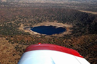
Tswaing is an impact crater in South Africa that is accompanied by a museum. It is situated 40 km to the north-west of Pretoria. This astrobleme is 1.13 km in diameter and 100 m deep and the age is estimated to be 220,000 ± 52,000 years (Pleistocene). The impactor is believed to have been a chondrite or stony meteorite some 30 to 50 m in diameter that was vapourised during the impact event. Morokweng crater, another crater of chondrite origin, lies north-west of Vryburg.
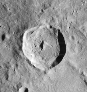
Agrippa is a lunar impact crater that is located at the southeast edge of the Mare Vaporum. It is located to the north of the crater Godin, the irregular Tempel lies just to the east. To the north and northeast, the rille designated Rima Ariadaeus follows a course to the east-southeast, reaching the western edge of Mare Tranquillitatis. It is named after the 1st century Greek astronomer Agrippa. Its diameter is 44 km (27 mi).
Ovillers-la-Boisselle is a commune in the Somme department in Hauts-de-France in northern France.

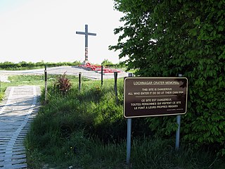
The Lochnagar mine south of the village of La Boisselle in the Somme département was an underground explosive charge, secretly planted by the British during the First World War, to be ready for 1 July 1916, the first day on the Somme. The mine was dug by the Tunnelling Companies of the Royal Engineers under a German field fortification known as Schwabenhöhe.
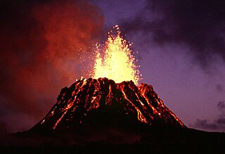
Puʻu ʻŌʻō is a volcanic cone in the eastern rift zone of the Kīlauea volcano of the Hawaiian Islands. Until the end of April 2018, Puʻu ʻŌʻō had been erupting nearly continuously since January 3, 1983, making it the longest-lived rift-zone eruption of the last two centuries.

Aracar is a large conical stratovolcano in northwestern Argentina, just east of the Chilean border. It has a main summit crater about 1–1.5 kilometres (0.6–0.9 mi) in diameter which sometimes contains crater lakes, and a secondary crater. The volcano has formed, starting during the Pliocene, on top of a lava platform and an older basement. Constructed on a base with an altitude of 4,100 metres (13,500 ft), it covers a surface area of 192.4 square kilometres (74.3 sq mi) and has a volume of 148 cubic kilometres (36 cu mi). The only observed volcanic activity was a possible steam or ash plume on March 28, 1993, seen from the village of Tolar Grande about 50 km (31 mi) southeast of the volcano, but with no evidence of deformation of the volcano from satellite observations. Inca archeological sites are found on the volcano.

Puna is one of the 9 districts of Hawaii County on the Island of Hawaiʻi. It is located on the windward side of the island and shares borders with South Hilo district in the north and Kaʻū district in the west. With a size of just under 320,000 acres (1,300 km2) or 500 sq. miles. Puna is slightly smaller than the island of Kauaʻi.

Tejeda is a village and a municipality in the mountainous central part of the island of Gran Canaria in the province of Las Palmas in the Canary Islands.

Salina is one of the Aeolian Islands north of Sicily, southern Italy. It is the second largest island in the archipelago.

Rim Village is the main area for tourist services in Crater Lake National Park in southern Oregon, United States. It is located on the southwest rim of the caldera overlooking Crater Lake. The National Park Service designed Rim Village to concentrate park services at a location that provided easy access to rim trails and view points. Because of the unique rustic architecture of the Rim Village structures and the surrounding park landscape, the area was listed as Rim Village Historic District on the National Register of Historic Places in 1997.

Comfort Station No. 68 is a historic visitor services building in Crater Lake National Park in southern Oregon, United States. It was built in 1938 to provide a public toilet and shower facilities for park visitors. It was constructed in the National Park Service Rustic style of architecture, and was listed on the National Register of Historic Places in 1988.

Rim Drive is a scenic highway in Crater Lake National Park in southern Oregon, United States. It is a 33-mile (53 km) loop that follows the caldera rim around Crater Lake. Due to its unique engineering and the surrounding park landscape, the drive was listed as a historic district on the National Register of Historic Places in 2008.

Kaali is a village in Saaremaa Parish, Saare County in western Estonia, 18 kilometres (11 mi) from Kuressaare, the island capital. Valjala, to the north-east, is the nearest town.

The Odessa Meteor Crater is a meteorite crater in the southwestern part of Ector County, southwest of the city of Odessa of West Texas, United States. It is accessible approximately 3 mi (5 km) south of Interstate 20 at Exit 108. This is one of three impact crater sites found in Texas, the others being the older and much larger Sierra Madera crater and the Marquez crater.

Kagisano-Molopo Local Municipality is a local municipality in the Dr Ruth Segomotsi Mompati District Municipality, in the North West province of South Africa. It was created at the local government elections of 18 May 2011 by merging the Kagisano and Molopo municipalities.


