Pietermaritzburg is the capital and second-largest city in the province of KwaZulu-Natal, South Africa. It was founded in 1838 and is currently governed by the Msunduzi Local Municipality. Its Zulu name umGungundlovu is the name used for the Umgungundlovu District Municipality. Pietermaritzburg is popularly called Maritzburg in Afrikaans, English and Zulu alike, and often informally abbreviated to PMB. It is a regionally important industrial hub, producing aluminium, timber and dairy products, as well as the main economic hub of Umgungundlovu District Municipality. The public sector is a major employer in the city due to local, district and provincial government offices located here.
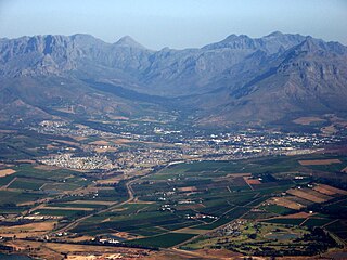
Stellenbosch is a town in the Western Cape province of South Africa, situated about 50 kilometres east of Cape Town, along the banks of the Eerste River at the foot of the Stellenbosch Mountain. The town became known as the City of Oaks or Eikestad in Afrikaans and Dutch due to the large number of oak trees that were planted by its founder, Simon van der Stel, to grace the streets and homesteads.
Kokstad is a town in the Harry Gwala District Municipality of KwaZulu-Natal Province, South Africa. Kokstad is named after the Griqua chief Adam Kok III who settled here in 1863. Kokstad is the capital town of the East Griqualand region, as it is also the biggest town in this region. It was built around Mount Currie, a local mountain range, by the city's founder Adam Kok III, for whom the town is named. Stad is the Dutch and Afrikaans word for "city".
Schweizer-Reneke, sometimes referred to as Schweizer, is a town in the North West Province of South Africa. It is the administrative centre of Mamusa Local Municipality. It is commonly referred to as Schweizer/ Mzwera.

Welkom is the second-largest city in the Free State province of South Africa, located about 140 kilometres (90 mi) northeast of Bloemfontein which is the provincial capital. Welkom is also known as Circle City, City Within A Garden, Mvela and Matjhabeng. The city's Sesotho name, Matjhabeng means 'where nations meet', derived from the migrant labour system, where people of various countries such as Lesotho, Malawi and Mozambique etc. met to work in the mines of the gold fields.

Lydenburg, is a town in Thaba Chweu Local Municipality, on the Mpumalanga highveld, South Africa. It is situated on the Sterkspruit/Dorps River tributary of the Lepelle River at the summit of the Long Tom Pass. It has a long, rich history, ranging from AD 500 to the present. The name is derived from the Dutch Lijdenburg, or "Town of Suffering", and is named for the experiences of the white settlers. In Northern Sotho, Mashishing means "long green grass." Lydenburg has become the centre of the South African fly-fishing industry and is an agricultural, tourism and mining hub.
Bethlehem is a city in the eastern Free State province of South Africa that is situated on the Liebenbergs river along a fertile valley just north of the Rooiberg Mountains on the N5 road. It is the fastest growing city in the Free state province, with its target of being the third largest city after Bloemfontein and Welkom.

Senekal is a town situated on the banks of the Sand River in the eastern part of the Free State province of South Africa. It was named after Commandant FP Senekal. It is the second largest town in Setsoto Municipality after Ficksburg, the largest town and capital of Setsoto. Senekal lies on the N5 national road between Winburg on the west and Bethlehem to the east. It has two townships, Matwabeng and OR Tambo Section, the latter being the latest, largest and fastest growing.

The town of Hoopstad is situated at the intersection of the R34, R59 & R700 in the Free State Province. This area is considered to be the richest maize-producing district in South Africa. The town is located near the Bloemhof Dam which is situated on the Vaal River. The Sandveld Nature Reserve is positioned alongside the Bloemhof Dam. Hopetown and Hoopstad are two different towns and are often confused.
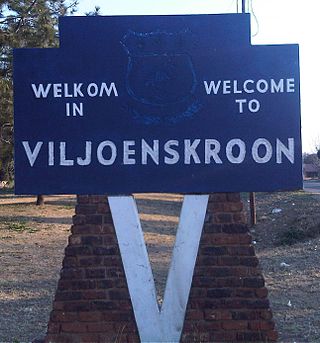
Viljoenskroon is a maize and cattle farming town located in the Free State province of South Africa. It was named after the original farm owner J. J. Viljoen and his horse Kroon (Crown). The town was laid out in 1921 on the farm "Mahemskuil" and became a municipality in 1925.

Standerton is a large commercial and agricultural town lying on the banks of the Vaal River in Mpumalanga, South Africa, which specialises in cattle, dairy, maize and poultry farming. The town was established in 1876 and named after Boer leader Commandant A. H. Stander. During the First Boer War a British garrison in the town was besieged by the Boers for three months. General Jan Smuts won this seat during elections and went on to assist in setting up the League of Nations. Standerton is part of the Lekwa Local Municipality.

Verulam is a town 24 kilometres north of Durban in KwaZulu-Natal, South Africa and forms part of the eThekwini Metropolitan Municipality, governing the Greater Durban metropolitan area.
Lephalale, also known as Ellisras, is a coal mining town in the Limpopo province of South Africa immediately east of the Waterberg Coalfield. The town was established as Ellisras in 1960 and named after Patrick Ellis and Piet Erasmus who settled on a farm there in the 1930s. In 2002, Ellisras was renamed Lephalale by the provincial government of Limpopo, after the main river that crosses the municipality. Lephalale is divided into three main subsections, Ellisras, Onverwacht and Marapong. Lephalale is derived from the setswana language meaning "to flow".
Rustenburg is a city at the foot of the Magaliesberg mountain range. Rustenburg is the most populous city in North West province, South Africa. In 2017, the city's Gross Domestic Product (GDP) reached ZAR 63.8 billion, accounting for 21.1% of the GDP of the North West Province, and 1.28% of the GDP of South Africa. Rustenburg was one of the official host cities of the 2010 FIFA World Cup, being in close proximity to Phokeng, the capital of the Royal Bafokeng Nation, where the Royal Bafokeng Stadium is located. The England national football team also used this as their base camp for the tournament.

Wolmaransstad is a maize-farming town situated on the N12 between Johannesburg and Kimberley in North West Province of South Africa. The town lies in an important alluvial diamond-mining area and it is the main town of the Maquassi Hills Local Municipality.
Thohoyandou is a town in the Limpopo Province of South Africa. It is the administrative centre of Vhembe District Municipality and Thulamela Local Municipality. It is also known for being the former capital of the bantustan of Venda.

Tzaneen is a large tropical garden town situated in the Mopani District Municipality of the Limpopo province in South Africa. It is situated in a high rainfall fertile region with tropical and subtropical agriculture taking place in a 20,000 square kilometres (7,700 sq mi) region. It is Limpopo's second largest town after Polokwane.

Grassy Park is a suburb of the City of Cape Town in the Western Cape Province of South Africa.
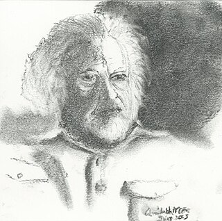
Moosa Moolla was an Indian South African activist and diplomat. A member of the African National Congress, Moolla was arrested and eventually found not guilty in the 1956 Treason Trial. In 1961, he was arrested and tried for incitement at the time of the May 1961 stay-at-home protest. In May 1963, he was arrested under the 90-day law. On 11 August 1963, Moolla and others escaped prison by bribing a young guard. He later served as the ANC representative to Asia while living in exile in India. Following independence, he became the first South African ambassador to Iran.
Jane Furse is a town in the Sekhukhune District Municipality of the Limpopo province in South Africa, surrounded by the villages of Ga-Moretsele, Madibong, Marulaneng, Mamone, Mokwete and Riverside.


