
Tasmania is an island state of Australia. It is located 240 km (150 mi) to the south of the Australian mainland, separated by the Bass Strait. The state encompasses the main island of Tasmania, the 26th-largest island in the world, and the surrounding 1000 islands. The state has a population of about 541,000 people as of September 2020. The state capital and largest city is Hobart, with around 40 percent of the population living in the Greater Hobart area.

Narawntapu is a national park in Tasmania, Australia. It lies on Tasmania's north coast, adjoining Bass Strait, between Port Sorell in the west and the mouth of the Tamar River in the east. It lies about 20 km east of Devonport, 60 km north-west of Launceston and 250 km north of Hobart.

The Aboriginal Tasmanians are the Aboriginal people of the Australian island of Tasmania, located south of the mainland. For much of the 20th century, the Tasmanian Aboriginal people were widely, and erroneously, thought of as being an extinct cultural and ethnic group that had been intentionally exterminated by white settlers. Contemporary figures (2016) for the number of people of Tasmanian Aboriginal descent vary according to the criteria used to determine this identity, ranging from 6,000 to over 23,000.

Pademelons are small marsupials of the genus Thylogale found in Australia and New Guinea. They are some of the smallest members of the family Macropodidae. Their common name is derived from the word badimaliyan, from the Dharuk Aboriginal language of Port Jackson, while the scientific name comes from the Greek words for "pouch" and "weasel".

Tasmania Football Club, commonly known as the Tasmanian Devils, was an Australian rules football club which competed in the Victorian Football League in Australia. Formed in 2001, it was the youngest and the only non-Victorian club in the league. The club was based in the state of Tasmania at Bellerive Oval and was run by AFL Tasmania. At the end of the 2008 season, AFL Tasmania decided to withdraw the Devils from the VFL competition in favour of restarting a new Tasmanian league encompassing the entire state.

The Tasmanian pygmy possum, also known as the little pygmy possum or tiny pygmy possum, is the world's smallest possum. It was first described by Oldfield Thomas in 1888, after he identified that a museum specimen labelled as an eastern pygmy possum in fact represented a species then unknown to science. The holotype resides in the Natural History Museum in London.
The Shell Islets are a group of a small islands in south-eastern Australia with two subsidiary islets, surrounded by extensive sand and mudflats at low tide, with a combined high tide area of 0.082 ha. They are part of Tasmania’s Trefoil Island Group, lying close to Cape Grim, Tasmania's most north-westerly point, in Bass Strait.
Howie Island is an island, with an area of 4.1 ha, in south-eastern Australia. It is part of the Petrel Island Group, lying in Bass Strait close to Walker and Robbins Islands in north-west Tasmania. It is surrounded by extensive mudflats.
The Anderson Island, also known as Woody Island, part of the Tin Kettle Island Group of the Furneaux Group, is a 166-hectare (410-acre) granite island, located in Bass Strait, lying northeast of Tasmania, in south-eastern Australia. Anderson Island lies between Flinders and Cape Barren Islands and is partly a pastoral lease used for grazing sheep and cattle. The island is joined at low tide to nearby Little Anderson and Tin Kettle Islands by extensive intertidal mudflats. The island is supposed to be named after John Anderson, a sealer living on the island by 1842.
Little Anderson Island is an island, with an area of 13 ha, in south-eastern Australia. It is part of Tasmania’s Tin Kettle Island Group, lying in eastern Bass Strait between Flinders and Cape Barren Islands in the Furneaux Group. The island is joined at low tide to nearby Anderson and Tin Kettle Islands by extensive intertidal mudflats. The island is part of the Franklin Sound Islands Important Bird Area, identified as such by BirdLife International because it holds over 1% of the world populations of six bird species.
Mid Woody Islet is a small island, with an area of 0.66 ha, in south-eastern Australia. It is part of Tasmania’s Tin Kettle Island Group, lying in eastern Bass Strait between Flinders and Cape Barren Islands in the Furneaux Group. The island is joined at low tide to nearby Anderson, Little Anderson and Tin Kettle Islands by extensive intertidal mudflats. The island is part of the Franklin Sound Islands Important Bird Area, identified as such by BirdLife International because it holds over 1% of the world populations of six bird species.

Tin Kettle Island is a long, sandy island, with an area of 176 ha, in south-eastern Australia. It is part of Tasmania’s Tin Kettle Island Group, lying in eastern Bass Strait between Flinders and Cape Barren Islands in the Furneaux Group. The island is joined at low tide to nearby Anderson and Little Andersons by extensive intertidal mudflats. The island is farmed, mainly cattle grazing. The island is part of the Franklin Sound Islands Important Bird Area, identified as such by BirdLife International because it holds over 1% of the world populations of six bird species.

Neds Reef is a group of three small granite islets, joined at low tide by extensive mudflats, with a combined area of about 3 ha, in south-eastern Australia. They are part of Tasmania’s Tin Kettle Island Group, lying in eastern Bass Strait between Flinders and Cape Barren Islands in the Furneaux Group. The reef is part of the Franklin Sound Islands Important Bird Area, identified as such by BirdLife International because it holds over 1% of the world populations of six bird species.
Samphire Island is a small shell-grit island, with an area of 3.3 ha, in south-eastern Australia. It is part of Tasmania’s Great Dog Island Group, lying in eastern Bass Strait between Flinders and Cape Barren Islands in the Furneaux Group. It is surrounded by mudflats at low tide.
Puncheon Island is an island, with an area of 17.56 ha, in south-eastern Australia. It is part of Tasmania’s Vansittart Island Group, lying in eastern Bass Strait between Flinders and Cape Barren Islands in the Furneaux Group. It is surrounded by mudflats. It is privately owned and used for farming. It has been extensively burnt and grazed.

The East Kangaroo Island, part of the Big Green Group within the Furneaux Group, is a 157-hectare (390-acre) unpopulated limestone island with granite outcrops and dolerite dykes, located in the Bass Strait, west of the Flinders Island, in Tasmania, in south-eastern Australia.
The Big Green Island, part of the Big Green Group within the Furneaux Group, is a 122-hectare (300-acre) granite island with limestone and dolerite outcrops, located in Bass Strait west of Flinders Island, in Tasmania, in south-eastern Australia. The island is partly contained within a nature reserve with the rest being used for farming; and is part of the Chalky, Big Green and Badger Island Groups Important Bird Area.
Red foxes pose a serious conservation problem in Australia. 2012 estimates indicate that there are more than 7.2 million red foxes and growing with a range extending throughout most of the continental mainland. The species became established in Australia through successive introductions by settlers in 1830s. Due to its rapid spread and ecological impact it has classified as one of the most damaging invasive species in Australia.
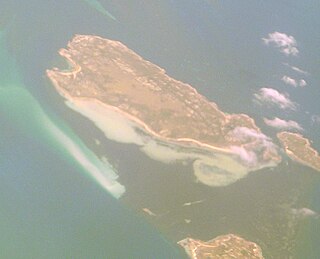
The Robbins Passage and Boullanger Bay Important Bird Area is a 238 km2 tract of land at the western end of the north coast of Tasmania, south-eastern Australia. It comprises extensive areas of intertidal mudflats and saltmarsh with adjacent farmland. It is an important site for waders, or shorebirds.
Rebe Taylor is an English-born Australian historian and author specialising in southeast Australian indigenous peoples and European settlement.
