Kangasala

Last updated

Kangasala
City
Kangasalan kaupunki
Kangsala stad
Kangasala-talo kesaaamun valossa.jpg
Kangasala-talo, cultural building in Kangasala
Kangasala.vaakuna.svg
Kangasala sijainti Suomi.svg
Coordinates: 61°28′N024°04′E / 61.467°N 24.067°E / 61.467; 24.067
CountryFlag of Finland.svg  Finland
Region Pirkanmaa
Sub-region Tampere sub-region
Metropolitan area Tampere metropolitan area
Charter 1865
Government
  City managerOskari Auvinen
Area
 (2018-01-01) [1]
  Total870.86 km2 (336.24 sq mi)
  Land658.02 km2 (254.06 sq mi)
  Water212.83 km2 (82.17 sq mi)
  Rank 130th largest in Finland
Population
 (2023-12-31) [2]
  Total33,473
  Rank 35th largest in Finland
  Density50.87/km2 (131.8/sq mi)
Population by native language
[3]
   Finnish 96.4% (official)
   Swedish 0.2%
  Others3.4%
Population by age
[4]
  0 to 1418.8%
  15 to 6460.2%
  65 or older20.9%
Time zone UTC+02:00 (EET)
  Summer (DST) UTC+03:00 (EEST)
Website www.kangasala.fi
Lake Roine seen from Vehoniemi ridge Nakyma Roineelle Vehoniemenharjulta.jpg
Lake Roine seen from Vehoniemi ridge

Kangasala is a town in Finland, located in the Pirkanmaa region. It lies to the east of the regional capital, Tampere. The population of Kangasala is approximately 33,000, while the metropolitan area has a population of approximately 417,000. It is the 35th most populous municipality in Finland.

Contents

Kangasala was founded in 1865. The town covers an area of 870.86 km2 (336.24 sq mi) of which 212.83 km2 (82.17 sq mi) is water. [1] The population density is 50.87 inhabitants per square kilometre (131.8/sq mi).

Kangasala is known for its mansions, such as Liuksiala, where the Swedish queen Karin Månsdotter lived as a widow, and Wääksy. Kangasala has a long history of tourism due to its cultural aspect, especially its museums. The landscape includes ridges and lakes. For example, the lakes Roine, Längelmävesi and Vesijärvi are located in Kangasala. These lakes are mentioned in Topelius' poem. Lake Vesijärvi is known as the lake with the scenic view described in the poem.

The municipality of Sahalahti was merged with Kangasala in 2005 and the municipality of Kuhmalahti in 2011. [5]

Tourism

Springs

Kangasala was known to be a popular destination in the 18th century. At that time, the waters of Kuohu Spring (Kuohunlähde) were believed to have healing powers on those who ventured into it and Kangasala became known among tourists as a place to rest. Refreshing in a health spa, bathing, taking outdoor exercise and "taking the waters" were popular amongst the aristocracy. It was also the reason why the first tourists came to Kangasala to spend their holidays there.

A water well building was built by the Kuohu Spring, which was later followed by a separate restaurant and hotel. [6] Spa tourism if often considered to be a predecessor of modern holiday making. However, at the time, it was primarily a pastime of the nobles and the prosperous bourgeoisie only.

Ridges

The golden age of spa tourism lasted about a hundred years, as interest in health springs began to decline in the 1840s. The artists of the Romantic period admired nature and frequently praised its beauty. Artists were drawn to Kangasala to view the landscapes. Amongst university students, wandering their homeland's natural environment became a way of showing patriotic love.

In 1775, the king of Sweden, Gustav III, was so taken by the scenery of the Syrjänkorkee ridge that he believed it to have been the very place where Satan tempted Jesus and promised him all the wonders of the world. Syrjänkorkee also made an impression on the Russian tsar and Grand Duke of Finland, Alexander I, in 1819. Thus, it was later renamed Keisarinharju, which can be translated as 'Emperor's Ridge'.

In addition to Keisarinharju, there are three other ridges that are popular panoramic sightseeing locations. The largest and highest of these is Kirkkoharju, also called Helaamäki, which stretches from Vatiala to the church of Kangasala. Kuohunharju (Kuohu Ridge) and Vehoniemenharju (Vehoniemi Ridge) are also well known for their views. Haralanvuori, or Haralanharju, located in Suinula, northern Kangasala, is a rocky hill, despite its second name.

A Summer's Day in Kangasala

In the Summer of 1853, Helsinki suffered from a cholera epidemic. Zacharias Topelius escaped the disease by retreating to the countryside. He visited lieutenant-colonel Aminoff's farm near Haralanvuori with his female acquaintance, Lotta Lindqvist. Topelius became fond of the views from the "Harjula ridge" and wrote his famous poem "A Summer's Day in Kangasala". Later, Gabriel Linsén composed a melody for the poem. From 1995, the melody has been the provincial hymn of the Pirkanmaa region, and it is one of the most widely known Finnish melodies.

Landscapes

Landscape from Kangasala by Eero Jarnefelt in 1891 Eero Jarnefelt - Landscape from Kangasala.jpg
Landscape from Kangasala by Eero Järnefelt in 1891

The landscapes of Kangasala made an impression on other Finnish authors as well. Poets like Frans Mikael Franzén, Johan Jakob Nervander, Emil von Qvanten, and Johan Ludvig Runeberg wrote about the environment. [7] [ citation needed ]

These landscapes were a source for an arising sense of nationality and arts that were means of concretizing the admiration and pride directed at them. In particular, the early 19th-century art of painting, with its idyllic portraits of country and nature, expresses the intellectual world of Romanticism. The countryside is filled with fields, forests, hills, ridges, lakes, and rivers.

In the 19th century, Kangasala's landscapes were painted by several famous painters. The earliest portrayers of the local landscape include Emanuel Thelning, a Swede sent to Kangasala by baron Gustaf Mauritz Armfelt, after he himself had visited the healing spring of Kuohu in 1811, and the German Carl von Kügelgen, royal painter of Alexander I, who painted at least three paintings representing Kangasala. His workpiece Vues pittoresques de la Finlande, which includes 15 lithographs, is often considered the start of Finnish landscape painting. The Hermitage in St. Petersburg contains pieces of art by von Kügelgen.

Other artists who painted Kangasala were Werner Holmberg, Einar Ilmoni, Eero Järnefelt, Hjalmar Munsterhjelm, Sigurd Wettenhovi-Aspa and Magnus von Wright, who painted six paintings on Kangasala in the 1860s.

The invention of dry plate photography in 1882 made taking photographs easier and cheaper. Furthermore, landscape photography has started to gain popularity in the city. As far as is currently known, the first actual landscape photographs in Kangasala were taken by Gustin Lojander in 1893. His series of photographs presented the landscapes and sightseeing of Kangasala.

The increased popularity of landscape photography decreased artists' interest in the province of Tavastia (Häme). The search for the roots of Finnishness has now turned towards Karelia (Karjala). Still, Kangasala wasn't forgotten by artists. The number of local artists – who often were landscapists of their home district – kept on growing. Photographs helped in making the nation aware of Kangasala's landscapes. At the end of the 19th century, advances in the printing press made it possible to spread pictures throughout the country in the form of affordable picture postcards.

Observation towers

The rebuilt Haralanharju Observation Tower in 2013 Haralanharjun nakotorni.jpg
The rebuilt Haralanharju Observation Tower in 2013

The artists' descriptions of Kangasala lured more and more travelers to the parish. People had to climb high, even up the trees, to be able to see the views. Although the ridgetops were relatively treeless at that time – because of the sawmill industry's great demand for wood – the construction of observation towers was considered necessary to provide new viewpoints. Many lookout spots (except Kuohunharju) got their own observation towers in the 1880s or 1890s. The first observation tower was built on Keisarinharju in 1881. A panoramic pavilion had been built there at the time of the visit of Alexander I, but it had already vanished by the 1850s. The towers at Haralanharju and Keisarinharju were destroyed by an arsonist in 2006 and 2007. Now only the towers at Vehoniemenharju and Kirkkoharju remain, but plans were in progress for rebuilding both towers within a year of the first arson. The Haralanharju tower was rebuilt and finished in 2008, however the Keisarinharju tower was never built into its original height. Instead a shorter observation spot known as Keisarinportaat was built on its place.

The ridges of Kangasala and Tampere are part of the same ridge formation. Travelers often used to visit both the ridges of Kangasala and Pyynikinharju (Pyynikki Ridge) in Tampere. Together, they were the most popular tourist attractions in Western Finland. In 1890, approximately 800 visitors came to Kangasala, 1,200–1,400 visited Pyynikki, and Imatra, the most popular tourist attraction in Finland at the time, was a destination for about 5,000 tourists.

The ideological conceptions created by the artist had a great influence on the Finnish sense of nationality, as had picture postcards and the lake views from the observation towers. When the period of Russification began at the end of the 19th-century, Finnish nature worked as an upbringing force for national self-esteem and as a unifier of Finnish culture. Kangasala played a role in that development.

Notable residents

See also

A 19th century wooden church in the Sahalahti village Sahalahden kirkko.JPG
A 19th century wooden church in the Sahalahti village

Related Research Articles

<span class="mw-page-title-main">Tampere</span> Second-most populous urban area in Finland

Tampere is a city in Finland and the regional capital of Pirkanmaa. It is located in the Finnish Lakeland. The population of Tampere is approximately 255,000, while the metropolitan area has a population of approximately 417,000. It is the 3rd most populous municipality in Finland, and the second most populous urban area in the country after the Helsinki metropolitan area.

<span class="mw-page-title-main">Pirkkala</span> Municipality in Pirkanmaa, Finland

Pirkkala is a municipality in Finland, located in the Pirkanmaa region. It lies to the southwest of the regional capital, Tampere. The population of Pirkkala is approximately 21,000, while the metropolitan area has a population of approximately 417,000. It is the 50th most populous municipality in Finland.

<span class="mw-page-title-main">Pirkanmaa</span> Region of Finland

Pirkanmaa, also known as Tampere Region in government documents, is a region of Finland. It borders the regions of Satakunta, South Ostrobothnia, Central Finland, Päijät-Häme, Kanta-Häme and Southwest Finland. Most of the water area in the Kokemäki River watershed is located in the Pirkanmaa region, although Lake Vanajavesi is partly in the Kanta-Häme region. The region got its name from Pirkkala, which in the Middle Ages comprised most of present-day Pirkanmaa. Tampere is the regional center and capital of Pirkanmaa, and at the same time the largest city in the region.

<span class="mw-page-title-main">Ikaalinen</span> City in Pirkanmaa, Finland

Ikaalinen is a city and municipality of Finland. It is part of the Pirkanmaa region, located 55 kilometres (34 mi) northwest of Tampere. The town has a population of 6,850 (31 December 2023) and covers an area of 843.40 square kilometres (325.64 sq mi) of which 93.16 km2 (35.97 sq mi) is water. The population density is 9.13 inhabitants per square kilometre (23.6/sq mi).

<span class="mw-page-title-main">Karstula</span> Municipality in Central Finland, Finland

Karstula is a municipality of Finland founded in 1867. It is located in the Central Finland region. The municipality has a population of 3,625 and covers an area of 963.19 square kilometres (371.89 sq mi) of which 76.22 km2 (29.43 sq mi) is water. The population density is 4.09 inhabitants per square kilometre (10.6/sq mi).

<span class="mw-page-title-main">Hollola</span> Municipality in Päijänne Tavastia, Finland

Hollola is a municipality of Finland, located in the western part of the Päijänne Tavastia region. The municipality is unilingually Finnish and has a population of 22,885 and covers an area of 727.47 square kilometres (280.88 sq mi) of which 68.66 km2 (26.51 sq mi) is water. The population density is 35.13 inhabitants per square kilometre (91.0/sq mi).

<span class="mw-page-title-main">Orivesi</span> Town of Orivesi in Pirkanmaa, Finland

Orivesi is a town in Finland, located in the Pirkanmaa region. It lies to the northeast of the regional capital, Tampere. The population of Orivesi is approximately 9,000, while the metropolitan area has a population of approximately 417,000. It is the 112th most populous municipality in Finland.

<span class="mw-page-title-main">Pälkäne</span> Municipality in Pirkanmaa, Finland

Pälkäne is a municipality of Finland. It is part of the Pirkanmaa region. The municipality has a population of 6,337 and covers an area of 738.15 square kilometres (285.00 sq mi) of which 177.65 km2 (68.59 sq mi). The population density is 11.3 inhabitants per square kilometre (29/sq mi). Onkkaala is the administrative center of the municipality. Tampere is located 38 kilometres (24 mi) northwest of the center of Pälkäne.

<span class="mw-page-title-main">Pyynikki Summer Theatre</span> Open air theatre in Tampere, Finland

Pyynikki Summer Theatre or Pyynikki Open Air Theatre is a theatre operating in Tampere, Finland, known especially for its revolving auditorium. It is one of the largest summer theatres in Finland and has been running uninterrupted longer than any other open-air theatre in the country.

<span class="mw-page-title-main">Sastamala</span> Town in Pirkanmaa, Finland

Sastamala is a town in Finland, located in the Pirkanmaa region. Sastamala lies on both sides of River Kokemäenjoki in the southwest corner of Pirkanmaa. The population of Sastamala is approximately 24,000, while the sub-region has a population of approximately 26,000. It is the 44th most populous municipality in Finland.

<span class="mw-page-title-main">Mänttä-Vilppula</span> Town in Pirkanmaa, Finland

Mänttä-Vilppula is a town and municipality of Finland. The municipalities of Mänttä and Vilppula were consolidated into a single municipality on January 1, 2009. It is located in the Pirkanmaa region.

<span class="mw-page-title-main">Pispala</span> City area in Tampere, Finland

Pispala is a city area 2.5 km from the centre of Tampere, Finland. It is located on the northern slope of Pispalanharju, the highest esker in Finland.

<span title="Finnish-language text"><span lang="fi" style="font-style: normal;">Längelmävesi</span></span> Lake in Pirkanmaa, Finland

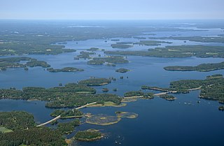
Längelmävesi is a lake in southwestern Finland. The lake is located mostly in the Pirkanmaa region at an elevation of 84.2 metres (276 ft). Längelmävesi is within the municipalities of Jämsä, Kangasala, Kuhmalahti, and Orivesi.

<span class="mw-page-title-main">Roine (Finland)</span> Lake in the country of Finland

Roine is a medium-sized lake in Finland. The lake is located in the Pirkanmaa region, mostly in the municipality of Kangasala and for a lesser part in the municipality of Pälkäne.

<span class="mw-page-title-main">Pyynikki observation tower</span> Observation, restaurant in Tampere, Finland

The Pyynikki observation tower is a 26 meter observation tower in Pyynikki, Tampere, Finland. It was completed in 1929 by the design of the city architect Vilho Kolho, and built using local red granite. The tower stands 75 meters above the level of the adjacent lake Pyhäjärvi on the ridge crest of the Pyynikki Esker.

<span class="mw-page-title-main">Pyynikki</span> City district in Tampere, Finland

Pyynikki is a district and a nature reserve in Tampere, Finland. It is located in the Pyynikinharju ridge, between the city center and the western district of Pispala. Pyynikinharju is the highest esker in the world, rising 85 meters above the level of lake Pyhäjärvi.

<span class="mw-page-title-main">Finnish national road 9</span> Finnish highway running from Turku to Tohmajärvi

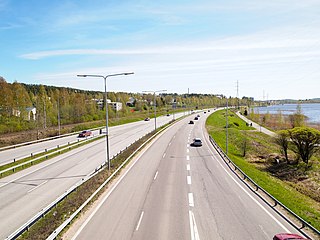
The Finnish national road 9 is a main route. It runs from Turku through Loimaa, Tampere, Jämsä, Jyväskylä, Kuopio, Outokumpu and Joensuu to the Niirala border guard station in Tohmajärvi, right next to the Russian border. The length of the road is 663 kilometres (412 mi).

<span class="mw-page-title-main">Pyynikki Esker</span> Geological feature in Tampere, Finland

The Pyynikki Esker is the tallest longitudinal esker in the world, located in Pyynikki, Tampere, Finland. The ridge rises to a height of 160 meters above sea level and 80 meters above the surface of Lake Pyhäjärvi. The Pyynikki Esker belongs to the ridge formation that extends from South Ostrobothnia to Salpausselkä. The ridge formation continues west of the Pyynikki Esker as a rocky ridge known as the Pispala Esker (Pispalanharju) and Tahmela. To the east, after the settlement of Tampere, the ridge becomes the Kalevankangas esker, where there has been a cemetery by same name for almost 150 years. In Kangasala, the ridge formation continues as the four ridges called Kirkkoharju, Kuohunharju, Keisarinharju and Vehoniemenharju. The Pyynikki Esker, like longitudinal ridges, is mainly gravel and sand.

<span class="mw-page-title-main">Kaakinmaa</span> City district in Tampere, Finland

Kaakinmaa is a district in Tampere, Finland, located in the city center. It includes the area south of Pyynikki Church Park between the Hämeenpuisto park and the Mariankatu street. To the south, the area extends to Eteläpuisto on the shores of Lake Pyhäjärvi. The neighboring parts of the city are Nalkala in the east, Amuri in the north and Pyynikki and Pyynikinrinne in the west. Sometimes Kaakinmaa is incorrectly considered to belong to Pyynikki and Pyynikinrinne; however, Kaakinmaa has its own district.

<span class="mw-page-title-main">Aitolahti</span> Former municipality in Pirkanmaa, Finland

Aitolahti is a former municipality in Pirkanmaa region, Finland. It was consolidated in 1966 with Tampere, and at the same time Tampere got new districts: Sorila, Nurmi and Aitoniemi. Until 1947, the neighboring municipalities of Aitolahti included Messukylä, which was consolidated with the city of Tampere. Highway 9 (E63) between Tampere and Jyväskylä and the regional road 338 between Tampere and Ruovesi pass through Aitolahti.

References

  1. 1 2 "Area of Finnish Municipalities 1.1.2018" (PDF). National Land Survey of Finland. Retrieved 30 January 2018.
  2. "Population growth biggest in nearly 70 years". Population structure. Statistics Finland. 26 April 2024. ISSN   1797-5395 . Retrieved 29 April 2024.
  3. "Population growth biggest in nearly 70 years". Population structure. Statistics Finland. 26 April 2024. ISSN   1797-5395 . Retrieved 29 April 2024.
  4. "Population according to age (1-year) and sex by area and the regional division of each statistical reference year, 2003–2020". StatFin. Statistics Finland . Retrieved 2 May 2021.
  5. "1.1.2011 yhdistyvien kuntien uudet nimet". Kunnat.net (in Finnish). Helsinki: Suomen Kuntaliitto. 2 July 2010. Retrieved 1 January 2011.[ permanent dead link ]
  6. Jalmari Meurman: Kangasalan terveyslähde, pages 8-9; Tampereen Kirjapaino-Osakeyhtiö 1935
  7. Fewster, Derek (2006). Visions of Past Glory: Nationalism & the Construction of Early Finnish History. Finnish Literature Society. ISBN   9517467877.