Kaokoland

Last updated

Kaokoland
1980–1989
Flag of South Africa (1982-1994).svg
Flag
MapBantoustanKaokoland.PNG
Map of the bantustan.
Status Bantustan de facto administered by Hereroland
Capital Opuwo
History 
 Established
1980
 Re-integrated into Namibia
May 1989
Currency South African rand
Preceded by
Succeeded by
Flag of South Africa 1928-1994.svg South West Africa
Namibia Flag of Namibia.svg
Plan Odendaal.png
Allocation of land to bantustans according to the Odendaal Plan. Kaokoland is in the north-west.

Kaokoland was an administrative unit and a bantustan in northern South West Africa (now Namibia). Established in 1980 during the apartheid era, it was intended to be a self-governing homeland of the Ovahimba, but an actual government was never established, and the territory was administered by the leaders of Hereroland. Like other homelands in South West Africa, the Kaokoland bantustan was abolished in May 1989, at the beginning of the transition of Namibia towards independence.

Contents

"Kaokoland" remains as an informal name for the geographic area, while the political unit of administration since 1990 has been Kunene Region. The area is in the Kaokoveld ecoregion. The area is one of the wildest and least populated areas in Namibia, with a population density of one person every 2 km² (1/4 of the national average). The most represented ethnic group is the Himba people, who account for about 5,000 of the overall 16,000 inhabitants of Kaokoland. The main settlement in Kaokoland was the city of Opuwo.

Geography

Rocky desert in Kaokoland Namibie Kaokoland 05.JPG
Rocky desert in Kaokoland

The Kaokoland area extends south-north from the Hoanib river to the Kunene river (that also marks the border between Namibia and Angola). It is largely mountainous, with the northern Baynes Mountains reaching their maximum elevation at 2039 m. Other notable mountain ranges of Kaokoland include the Otjihipa Mountains (to the north) [1] and the Hartmann Mountains (to the east). The land is generally dry and rocky, especially to the south, where it borders on the Namib Desert; nevertheless, it has several rivers as well as falls. The most notable falls in Kaokoland are the Ruacana Falls (120 m high, 700 m wide) and the Epupa Falls, both formed by the Kunene river. The northern part of Kaokoland is greener, with vegetation thriving valleys such as the Marienfluss and Hartmann Valley.

History

Before colonialism, Kaokoland was mostly inhabited by the Ovambo, Nama, and Herero people. In the second half of the 19th century, a group of Herero crossed the Kunene River, migrating north to what is now Angola, joining with the Bushmen in Southern Angola; the modern day Himba people originated from this Angolan Herero group. In 1884, Kaokoland became part of German South West Africa, and the Namibian Herero people changed much of their habits and costumes as a consequence of German rule. After World War I, South Africa received the mandate from the League of Nations to administer the territory of Namibia, which became, for all practical purposes, a province of South Africa. South Africa also applied to Namibia the principles of apartheid, including the creation of distinct bantustans (homelands) for different African ethnic groups. Kaokoland was thus established as a bantustan for the Himba people, who in the 1920s had come back from Angola into Namibia. Despite its scarce population, Kaokoland was greatly affected by the struggle for independence of Namibia, and most specifically by the so-called "bush war" that was fought across the border with Angola (i.e., in Kaokoland).

The Himba people

Himba woman Namibie Himba 0717a.jpg
Himba woman

The Himba people are the descendants of a Herero group that got isolated from the others in the 19th century. While the Herero people later experienced German rule and drastically changed their lifestyle as well as their costumes, the Himba retained much of their traditional, nomadic and pastoral habits. In recent times, contacts between Himbas and Western tourists are becoming more and more common, especially in the most easily accessible regions of Kaokoland (e.g., the surroundings of Opuwo). While this has partially affected the Himba culture, Himbas have essentially remained faithful to their tradition.

Fauna

Fauna in Kaokoland suffered from a severe crippling between 1977 and 1982, as well as from poaching throughout the 1970s, but has been recovering afterwards. It includes several desert-dwelling species, most notably a population of desert elephants that are sometimes classified as a distinct subspecies of African elephants because of their shorter legs and specific, desert-adapted behaviour (the only other place in Africa where elephants have adapted to a desert environment being Mali, on the border of the Sahara desert). Its longer legs, bigger feet, and incredible ability to withstand periods of drought all gave valid reasons to think so. Today, however, it is not considered a different species, rather regarded as only 'desert adapted.' The herds in this area remain separate from other elephant herds in Namibia and only appear to have longer legs and bigger feet, because they eat less than elephants living in more food abundant areas such as Etosha National Park, the Caprivi, and the Chobe region in Botswana.

The desert elephant populate a three-thousand square kilometre range and regularly travel up to two hundred kilometres in search of water. They only drink every three or four days, compared to elephants in Etosha drinking 100 to 200 L of water a day. They also seem to be more environmentally conscious than other elephants: unlike other elephants, the desert-adapted elephant rarely knock over trees, break branches, or tear away bark.

They are commonly roaming the dry riverbeds of the westward flowing Huab, Hoanib, Hoarusib, and Khumib rivers. It is along these riverbeds that the animals find the occasional spring fed waterhole and most of their nutrient rich foods: mopane bark, tamarisk, reeds, and the pods, bark, and leaves of the ana tree. On a typical day, desert elephants travel up to sixty kilometres over rocky, difficult terrain between feeding areas and waterholes. When water is truly scarce, as in times of drought, they dig holes, commonly known as gorras, in the dry riverbeds. Water seeps up from below the surface creating a much needed water source for themselves, and for other animals in the area; [2] unlike other elephants, which drink daily, desert elephants have been known to survive without water for up to four days.

Black rhinos were extinguished in the area in 1983, but they have been reintroduced. Other species found in Kaokoland include oryxes, kudus, springboks, ostriches, giraffes and mountain zebras.

Tourism and transportation

Mountains in Kaokoland Namibie Kaokoland 04.JPG
Mountains in Kaokoland

After the end of the bush war, Kaokoland has become a common tourist destination in Namibia, due to its proximity to the Etosha National Park (to the south), the unspoiled nature (with several spots suitable for activities such as rafting and trekking), and the opportunity to visit traditional Himba villages. Notable landmarks in the area include the Epupa Falls, Sesfontein, Himba villages, and the Ondurusa Rapids.

Kaokoland is one of the wildest regions of Southern Africa, with very few roads and structures. The only road that is accessible to non-4WD vehicles is the one connecting Sesfontein and Opuwo. Many roads in Kaokoland are often in very bad condition and may even be challenging for 4WDs, especially during the rainy season. Most services such as shops, a hospital and a fuel station, are only found in Opuwo.

Related Research Articles

<span class="mw-page-title-main">Geography of Namibia</span>

At 824,292 km2 (318,261 sq mi), Namibia is the world's thirty-fourth largest country. After Mongolia, Namibia is the second least densely populated country in the world. Namibia got its name from the Namib desert that stretches along the coast of the Atlantic. It is also known for its wildlife.

<span class="mw-page-title-main">Himba people</span> Ethnic group of Namibia

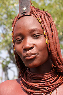
The Himba are an indigenous people with an estimated population of about 50,000 people living in northern Namibia, in the Kunene Region and on the other side of the Kunene River in southern Angola. There are also a few groups left of the OvaTwa, who the OvaHimba consider to be part of their tribe, but are hunter-gatherers. Culturally distinguishable from the Herero people, the OvaHimba are a semi-nomadic, pastoralist people and speak OtjiHimba, a variety of Herero, which belongs to the Bantu family within Niger–Congo. The OvaHimba are semi-nomadic as they have base homesteads where crops are cultivated, but may have to move within the year depending on rainfall and where there is access to water.

<span class="mw-page-title-main">Etosha National Park</span> National park of Namibia

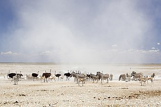
Etosha National Park is a national park in northwestern Namibia and one of the largest national parks in Africa. It was proclaimed a game reserve in March 1907 in Ordinance 88 by the Governor of German South West Africa, Friedrich von Lindequist. It was designated as Wildschutzgebiet in 1958, and was awarded the status of national park in 1967, by an act of parliament of the Republic of South Africa. It spans an area of 22,270 km2 (8,600 sq mi) and was named after the large Etosha pan which is almost entirely within the park. With an area of 4,760 km2 (1,840 sq mi), the Etosha pan covers 23% of the total area of the national park. The area is home to hundreds of species of mammals, birds and reptiles, including several threatened and endangered species such as the black rhinoceros. Sixty-one black rhinoceros were killed during poaching in Namibia during 2022, 46 of which were killed in Etosha.

<span class="mw-page-title-main">Kunene Region</span> Region in Namibia

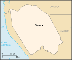
Kunene is one of the fourteen regions of Namibia. Its capital is Opuwo, its governor is Marius Sheya. The region's name comes from the Kunene River which forms the northern border with Angola. Besides the capital Opuwo, the region contains the municipality of Outjo, the town Khorixas and the self-governed village Kamanjab. Kunene is home to the Himba people, a subtribe of the Herero, as well as to Damara people and Nama people. As of 2020, Kunene had 58,548 registered voters.

<span class="mw-page-title-main">Cunene River</span> River in southern Africa

The Cunene or Kunene is a river in Southern Africa. It flows from the Angola highlands southwards to the border with Namibia. It then flows in a westerly direction along the border until it reaches the Atlantic Ocean. One of the few perennial rivers in the region, the Kunene is about 1,050 km (650 mi) long, with a drainage basin 106,560 km2 (41,140 sq mi) in area. Its mean annual discharge is 174 m3/s (6,100 cu ft/s) to 222 m3/s (7,800 cu ft/s) at its mouth. The Epupa Falls lie on the river. Olushandja Dam dams a tributary of the river, the Etaka, and helps to provide the Ruacana Power Station with water.

<span class="mw-page-title-main">Skeleton Coast</span> Atlantic coast of northern Namibia and southern Angola

The Skeleton Coast is the northern part of the Atlantic coast of Namibia. Immediately south of Angola, it stretches from the Kunene River to the Swakop River, although the name is sometimes used to describe the entire Namib Desert coast. The indigenous San people, of the Namibian interior called the region "The Land God Made in Anger", while Portuguese sailors once referred to it as "The Gates of Hell".

<span class="mw-page-title-main">Herero language</span> Bantu language of Namibia and Botswana

Herero (Otjiherero) is a Bantu language spoken by the Herero and Mbanderu peoples in Namibia and Botswana, as well as by small communities of people in southwestern Angola. There were 250,000 speakers in these countries between 2015 and 2018.

<span class="mw-page-title-main">Etosha Pan</span> Big endorheic salt ville in Namibias north

The Etosha Pan is a large endorheic salt pan, forming part of the Cuvelai-Etosha Basin in the north of Namibia. It is a vast hollow in the ground in which water may collect or in which a deposit of salt remains after water has evaporated. The 120-kilometre-long (75-mile-long) dry lakebed and its surroundings are protected as Etosha National Park, Namibia's second-largest wildlife park, covering 22,270 square kilometres (8,600 sq mi). The pan is mostly dry but after heavy rains it is flooded with a thin layer of water, which is heavily salted by the mineral deposits on the surface.

<span class="mw-page-title-main">Kaokoveld</span> Desert ecoregion in Angola and Namibia

The Kaokoveld Desert is a coastal desert of northern Namibia and southern Angola.

<span class="mw-page-title-main">Opuwo</span> Town in Kunene Region, Namibia

Opuwo is the capital of the Kunene Region in north-western Namibia. The town is situated about 720 km north-northwest of the capital Windhoek, and has a population of 20,000. It is the commercial hub of the Kunene Region.

<span class="mw-page-title-main">Epupa Falls</span> Series of waterfalls in Namibia

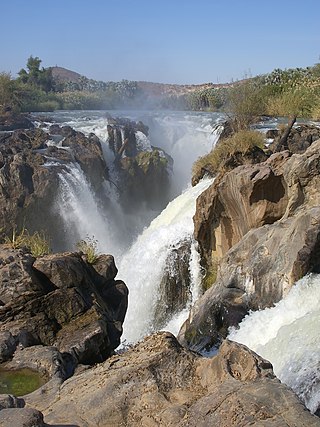
Epupa Falls is a series of large waterfalls formed by the Cunene River on the border of Angola and Namibia, in the Kaokoland area of the Kunene Region. The river is about 0.5 kilometres (1,600 ft) wide in this area and drops in a series of waterfalls across a length of 1.5 kilometres (0.93 mi), with the greatest single drop being 37 metres (121 ft) in height. The settlement near the falls is also called Epupa.

Articles related to Namibia include:

Blythe Loutit née Pascoe was a founder member of the Save the Rhino Trust (SRT), an artist and a respected conservationist.

<span class="mw-page-title-main">Angelika Muharukua</span> Namibian politician

Angelika Kazetjindire Muharukua was a Namibian politician. An ethnic Herero from northwestern Namibia, Muharukua joined the South West Africa People's Organization (SWAPO) in 1979. She was a surprise choice by President Sam Nujoma for the 2nd National Assembly of Namibia in 1995 and remained in the National Assembly since. In May 2004, she was chosen to replace Marlene Mungunda as deputy minister of Women Affairs and Child Welfare, later renamed the Ministry of Gender Equality and Child Welfare.

<span class="mw-page-title-main">Angolan mopane woodlands</span>

Angolan mopane woodlands are situated in southwestern Angola, extending into northern Namibia. This ecosystem surrounds Etosha Pan, which is considered a separate ecoregion. The mopane trees are the main type of vegetation.

<span class="mw-page-title-main">Swartbooisdrift</span> Settlement in Kunene Region, Namibia

Swartbooisdrift is a small settlement in the Kunene Region in the north of Namibia. It is situated on the banks of the Kunene River, at the Angolan border on the minor road D3700 and falls within the Epupa electoral constituency. Swartbooisdrift is populated by 150 - 300 semi-nomadic people of Himba and Herero descent, depending on the season.

The Cimba, also spelled Tjimba, are a remote, Herero-speaking hunter-gatherer people of the Kaokoveld desert in northwest Namibia and southwest Angola, in the mountain ranges bordering the Kunene River. They continue to use stone tools, and use Adenium boehmianum to poison their arrows.

The Zembapeople are a Bantu ethnic group residing in the border regions of Namibia and Angola. In Namibia, they are predominantly found in the Kunene region, most notably in the Opuwa area. They speak the Zemba language, also known as OtjiZemba or Dhimba. The Zemba are well-known for their distinctive hairstyles, intricate iron and copper jewelry, as well as traditional clothing that often incorporates animal hides. Additionally, they decorate themselves with a blend of ash, ochre paste, and rancid butter to enhance their appearance.

<span class="mw-page-title-main">Desert elephant</span> African bush elephants in deserts of Africa

Desert elephants or desert-adapted elephants are not a distinct species of elephant but are African bush elephants that have made their homes in the Namib and Sahara deserts in Africa. Previously they were classified as a subspecies of the African bush elephant, but this is no longer the case. Desert-dwelling elephants were once more widespread in Africa than they are at present; they are currently found only in Namibia and Mali. They tend to migrate from one waterhole to another following traditional routes which depend on the seasonal availability of food and water. They face being threatened by poaching and from changes in land use by humans.

Omaere is a fermented dairy product prepared in Namibia through the acidification of buttermilk It is produced especially in Kunene, Omaheke and Otjozondjupa regions and Botswana by the Ovaherero, Himba and Mbanderu tribes. However, it has become a popular beverage in many households and communities across Namibia and Southern Africa.

References

  1. "GeoNames.org". www.geonames.org.
  2. "Desert Elephants, Safari in Namibia |". Archived from the original on 2 April 2012. Retrieved 10 September 2011.

18°S13°E / 18°S 13°E / -18; 13