Kasota, Minnesota

Last updated
Kasota, Minnesota
Le Sueur County Minnesota Incorporated and Unincorporated areas Kasota Highlighted.svg
Location of Kasota, Minnesota
Coordinates: 44°17′30″N93°58′07″W / 44.29167°N 93.96861°W / 44.29167; -93.96861
CountryUnited States
State Minnesota
County Le Sueur
Government
  TypeMayor - Council
  MayorBridget Klein
Area
[1]
  Total1.28 sq mi (3.32 km2)
  Land1.24 sq mi (3.22 km2)
  Water0.04 sq mi (0.10 km2)
Elevation
[2]
801 ft (244 m)
Population
 (2020)
  Total714
  Density574.88/sq mi (221.91/km2)
Time zone UTC-6 (Central (CST))
  Summer (DST) UTC-5 (CDT)
ZIP code
56050
Area code 507
FIPS code 27-32462 [3]
GNIS feature ID2395494 [2]
Website kasotamn.gov

Kasota is a city within the larger Kasota Township, Le Sueur County, Minnesota, United States. The population was 714 at the 2020 census. [4]

Contents

Geography

Kasota is about halfway between Mankato and St. Peter on the eastern side of the Minnesota River. According to the United States Census Bureau, the city has an area of 1.00 square mile (2.59 km2), all land. [5] The city center is about two miles north of the Kasota Prairie, designated as a Scientific and Natural Area by the state Department of Natural Resources.

Minnesota State Highway 22 serves as a main route in the community. U.S. Route 169 is nearby, on the western side of the Minnesota River.

History

Kasota was platted in 1855. "Kasota" is a name derived from the Dakota language word for "cleared off". [6]

On July 1, 1892, the Sontag Brothers, John Sontag and George Contant, and their partner in crime, Chris Evans, tried to rob a train between St. Peter and Kasota along the Minnesota River. The bandits acquired nothing of value, but their activities came under the review of Pinkerton detectives, and both were apprehended in June 1893. [7]

The stone industry

The Kasota Village Hall is on the National Register of Historic Places. 2009-0805-Kasota-VillageHall.jpg
The Kasota Village Hall is on the National Register of Historic Places.

During the 1880s, the stone industry experienced an unexpected boom. During this time, C.W. Babcock took over his father's stone business. He began applying modern quarrying methods, and in 1889 formed a partnership with Tyrrell Swan Willcox, an immigrant from Rugby, England, who was instrumental in promoting the use of polished Kasota limestone for interior and exterior residential use. Much of the industry's boom was caused by the railroads' expansion westward, which required large quantities of stone for trestles and culverts. [8]

Babcock also was the first to begin quarrying Kasota limestone in and around the city of Kasota. The Babcock Company was the chief stone company during the city's early history, and the relationship between the company and the city was often contentions. At one point, the Babcock Company decided to blast within the city limits. This led to the creation of the park on County Road 21 in the town center, after the company was forced to fill in the quarry near the homes of city residents.[ citation needed ]

In the early 1980s, the Babcock Company went bankrupt. The Vetter Stone Company bought the Babcock quarries, further expanding the business, which now operates just outside the Mankato city limits. The Vetters were former employees of the Babcock Company who left to start their own company in the 1950s. The former Babcock Company plant in Kasota is now occupied by Door Engineering, which manufactures industrial doors. Much of the former Kasota quarry is occupied by Unimin Corporation, which mines silica sand for hydraulic fracturing ("fracking").

Kasota stone was selected as the primary stone for building the National Museum of the American Indian [9] and the Eiteljorg Museum of American Indians and Western Art in Indianapolis. [10]

Namesakes

Kasota (Dakota for "a cleared place") [11] was the name of a wooden Great Lakes iron ore steamer, built in 1884. [12] The Kasota sank after colliding with the passenger steamer The City of Detroit on the Detroit River on July 18, 1890. [13] The Kasota was salvaged and rebuilt in 1892 [13] but sank again after springing a leak during a storm off Grand Marais, Michigan, on September 19, 1903. [12]

The USS Kasota was a naval tugboat, launched in 1944 and struck from the Navy list in 1961. It is believed that the Kasota (also known as the "Mighty Deuces") was the last wooden hull tug in the Navy at the time. [14]

Demographics

Historical population
CensusPop.Note
1880 156
1890 655319.9%
1900 76416.6%
1910 700−8.4%
1920 686−2.0%
1930 593−13.6%
1940 6041.9%
1950 600−0.7%
1960 6498.2%
1970 73212.8%
1980 7391.0%
1990 655−11.4%
2000 6803.8%
2010 675−0.7%
2020 7145.8%
U.S. Decennial Census [15]
2020 Census [4]
Damage from the 2006 Dakota-Minnesota tornado outbreak in Kasota Kasota damage.jpg
Damage from the 2006 Dakota–Minnesota tornado outbreak in Kasota

2010 census

As of the census [16] of 2010, there were 675 people, 293 households, and 175 families residing in the city. The population density was 675.0 inhabitants per square mile (260.6/km2). There were 305 housing units at an average density of 305.0 per square mile (117.8/km2). The racial makeup of the city was 94.7% White, 1.2% African American, 0.6% Native American, 0.7% Asian, 0.9% from other races, and 1.9% from two or more races. Hispanic or Latino of any race were 2.2% of the population.

There were 293 households, of which 29.0% had children under the age of 18 living with them, 43.0% were married couples living together, 10.6% had a female householder with no husband present, 6.1% had a male householder with no wife present, and 40.3% were non-families. 31.7% of all households were made up of individuals, and 7.2% had someone living alone who was 65 years of age or older. The average household size was 2.30 and the average family size was 2.84.

The median age in the city was 36.9 years. 21.8% of residents were under the age of 18; 7.9% were between the ages of 18 and 24; 29% were from 25 to 44; 30.6% were from 45 to 64; and 10.8% were 65 years of age or older. The gender makeup of the city was 49.2% male and 50.8% female.

2000 census

As of the census [3] of 2000, there were 680 people, 275 households, and 196 families residing in the city. The population density was 673.4 inhabitants per square mile (260.0/km2). There were 279 housing units at an average density of 276.3 per square mile (106.7/km2). The racial makeup of the city was 95.59% White, 0.74% African American, 2.06% Native American, 0.15% Asian, 0.15% from other races, and 1.32% from two or more races. Hispanic or Latino of any race were 0.88% of the population.

There were 275 households, out of which 34.2% had children under the age of 18 living with them, 49.5% were married couples living together, 15.3% had a female householder with no husband present, and 28.4% were non-families. 21.1% of all households were made up of individuals, and 8.4% had someone living alone who was 65 years of age or older. The average household size was 2.46 and the average family size was 2.81.

In the city, the population was spread out, with 26.2% under the age of 18, 9.0% from 18 to 24, 27.9% from 25 to 44, 27.4% from 45 to 64, and 9.6% who were 65 years of age or older. The median age was 36 years. For every 100 females, there were 101.8 males. For every 100 females age 18 and over, there were 94.6 males.

The median income for a household in the city was $39,097, and the median income for a family was $43,750. Males had a median income of $30,300 versus $21,711 for females. The per capita income for the city was $17,503. About 6.6% of families and 7.8% of the population were below the poverty line, including 10.6% of those under age 18 and 16.9% of those age 65 or over.

See also

Chankaska Creek Ranch and Winery, [17] a local winery featured in several prominent wine magazines, [18] [19] which also has an event center and spirits. [20]

Related Research Articles

<span class="mw-page-title-main">Le Sueur County, Minnesota</span> County in Minnesota, United States

Le Sueur County is a county located in the south central portion of the U.S. state of Minnesota. As of the 2020 census, the population was 28,674. Its county seat is Le Center.

<span class="mw-page-title-main">Brown County, Minnesota</span> County in Minnesota, United States

Brown County is a county in the U.S. state of Minnesota. As of the 2020 census, the population was 25,912. Its county seat is New Ulm. The county was formed in 1855 and organized in 1856.

<span class="mw-page-title-main">Amboy, Minnesota</span> City in Minnesota, United States

Amboy is a city in Blue Earth County, Minnesota, United States. The population was 535 at the 2020 census. It is part of the Mankato-North Mankato Metropolitan Statistical Area. The city was founded in 1879. It celebrated its 125th anniversary in September 2004.

<span class="mw-page-title-main">Eagle Lake, Minnesota</span> Town in Minnesota, United States

Eagle Lake is in Blue Earth County, Minnesota, United States. The population was 3,278 at the 2020 census. It is part of the Mankato-North Mankato Metropolitan Statistical Area.

<span class="mw-page-title-main">Good Thunder, Minnesota</span> City in Minnesota, United States

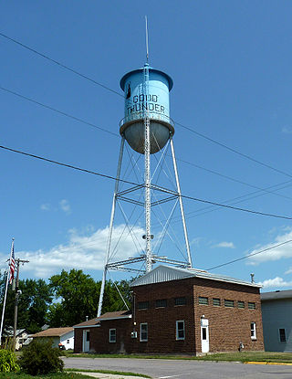
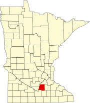
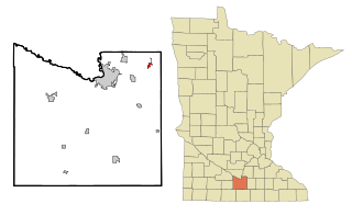
Good Thunder is a city in Blue Earth County, Minnesota, United States, situated along the Maple River. The population was 560 at the 2020 census. It is part of the Mankato–North Mankato Metropolitan Statistical Area.

Jamestown Township is a township in Blue Earth County, Minnesota, United States. The population was 628 as of the 2000 census.

Lime Township is a township in Blue Earth County, Minnesota, United States. The population was 1,395 as of the 2010 census.

<span class="mw-page-title-main">Madison Lake, Minnesota</span> City in Minnesota, United States

Madison Lake is a small city in Blue Earth County, Minnesota, United States. The population was 1,247 at the 2020 census. It is part of the Mankato-North Mankato Metropolitan Statistical Area.

Mankato Township is a township in Blue Earth County, Minnesota, United States. The population was 1,969 as of the 2010 census.

<span class="mw-page-title-main">Mapleton, Minnesota</span> City in Minnesota, United States

Mapleton is a city in Blue Earth County, Minnesota, United States. The population was 1,710 at the 2020 census. It is part of the Mankato-North Mankato Metropolitan Statistical Area.

South Bend Township is a township in Blue Earth County, Minnesota, United States. The population was 1,682 as of the 2010 census.

<span class="mw-page-title-main">St. Clair, Minnesota</span> City in Minnesota, United States

St. Clair or Saint Clair is a city in Blue Earth County, Minnesota, United States, located along the Le Sueur River. The population was 750 at the 2020 census. It is part of the Mankato-North Mankato Metropolitan Statistical Area.

<span class="mw-page-title-main">Vernon Center, Minnesota</span> City in Minnesota, United States

Vernon Center is a city in Blue Earth County, Minnesota, United States, along the Blue Earth River. The population was 328 at the 2020 census. It is part of the Mankato-North Mankato Metropolitan Statistical Area.

<span class="mw-page-title-main">Blue Earth, Minnesota</span> City in Minnesota, United States

Blue Earth is a city in Faribault County, Minnesota, United States, at the confluence of the east and west branches of the Blue Earth River. The population was 3,174 at the 2020 census. It is the county seat of Faribault County. It is home to a statue of the Jolly Green Giant. Additionally, Interstate 90 is centered on Blue Earth, as the east and west construction teams met here in 1978. As a tribute, there is a golden stripe of concrete on the interstate near Blue Earth. This draws an analogy to the golden spike set in the first transcontinental railroad. Approximately three miles south of Blue Earth is the Blue Earth Municipal Airport.

Kasota Township is a township in Le Sueur County, Minnesota, United States. The population was 1,487 at the 2000 census.

<span class="mw-page-title-main">Courtland, Minnesota</span> City in Minnesota, United States

Courtland is a city in Nicollet County, Minnesota, United States. The population was 734 at the 2020 census. It is part of the Mankato-North Mankato Metropolitan Statistical Area.

<span class="mw-page-title-main">Lafayette, Minnesota</span> City in Minnesota, United States

Lafayette is a city in Nicollet County, Minnesota, United States. The population was 492 at the 2020 census. It is a farming community just outside the larger town of New Ulm.

<span class="mw-page-title-main">Nicollet, Minnesota</span> City in Minnesota, United States

Nicollet is a city in Nicollet County, Minnesota, United States. The population was 1,143 at the 2020 census.

<span class="mw-page-title-main">Mankato, Minnesota</span> City in Minnesota, United States

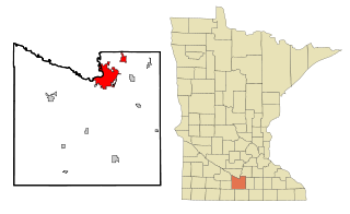
Mankato is a city in Blue Earth, Nicollet, and Le Sueur counties in the state of Minnesota. The population was 44,488 according to the 2020 census, making it the 21st-largest city in Minnesota, and the 5th-largest outside of the Minneapolis–Saint Paul metropolitan area. It is along a large bend of the Minnesota River at its confluence with the Blue Earth River. Mankato is across the Minnesota River from North Mankato. Mankato and North Mankato have a combined population of 58,763 according to the 2020 census. It completely encompasses the town of Skyline. North of Mankato Regional Airport, a tiny non-contiguous part of the city lies within Le Sueur County. Most of the city is in Blue Earth County.

<span class="mw-page-title-main">North Mankato, Minnesota</span> City in Minnesota, United States

North Mankato is a city in Nicollet and Blue Earth counties in the State of Minnesota. The population was 14,275 at the 2020 census.

References

  1. "2020 U.S. Gazetteer Files". United States Census Bureau. Retrieved July 24, 2022.
  2. 1 2 U.S. Geological Survey Geographic Names Information System: Kasota, Minnesota
  3. 1 2 "U.S. Census website". United States Census Bureau . Retrieved January 31, 2008.
  4. 1 2 "Explore Census Data". United States Census Bureau . Retrieved May 25, 2022.
  5. "US Gazetteer files 2010". United States Census Bureau. Archived from the original on January 12, 2012. Retrieved November 13, 2012.
  6. Upham, Warren (1920). Minnesota Geographic Names: Their Origin and Historic Significance. Minnesota Historical Society. p.  301.
  7. "The Sontag Brothers: Southern Minnesota's Own Train Robbers". mnriv.com. Retrieved November 28, 2012.
  8. Don Pauley et al. Kasota, a Historical Perspective. Mankato, MN: Mankato State University Urban and Regional Studies Institute, 1976.
  9. "Fossils in the Architecture of Washington, DC: A Guide to Washington's Accidental Museum of Paleontology". Dcfossils.org. September 21, 2004. Retrieved November 10, 2011.
  10. "The Eiteljorg Museum Building" (PDF).
  11. Upham, Warren (1920). Minnesota geographic names: their ... - Warren Upham - Google Books . Retrieved November 10, 2011.
  12. 1 2 "The Great Lakes Shipwreck File Vessel Names That Begin With P". Boatnerd.com. March 6, 1904. Retrieved November 10, 2011.
  13. 1 2 "Kasota (Propeller), sunk by collision, July 17, 1890: Maritime History of the Great Lakes". Images.maritimehistoryofthegreatlakes.ca. January 1, 2009. Retrieved November 10, 2011.
  14. "Kasota". Nafts.net. Retrieved November 10, 2011.
  15. "Census of Population and Housing". Census.gov. Retrieved June 4, 2015.
  16. "U.S. Census website". United States Census Bureau . Retrieved November 13, 2012.
  17. "Chankaska Creek Ranch & Winery". www.chankaskawines.com.
  18. "Chankaska Creek Ranch & Winery - World-Class Wines in Minnesota".
  19. "Chankaska Creek winery a Minnesota discovery".
  20. "Chankaska Spirits Ranch Road Gin – Heavy Table".