Windhoek is the capital and largest city of Namibia. It is located in central Namibia in the Khomas Highland plateau area, at around 1,700 m (5,600 ft) above sea level, almost exactly at the country's geographical centre. The population of Windhoek, which was 431,000 in 2020, is constantly growing due to a continued migration from other regions in Namibia.
Okahandja is a city of 24,100 inhabitants in Otjozondjupa Region, central Namibia, and the district capital of the Okahandja electoral constituency. It is known as the Garden Town of Namibia. It is located 70 km north of Windhoek on the B1 road. It was founded around 1800, by two local groups, the Herero and the Nama.
Otjimbingwe is a settlement in the Erongo Region of central Namibia. Otjimbingwe has approximately 8,000 inhabitants and belongs to the Karibib electoral constituency.
The Ovamboland People's Organization (OPO) was a nationalist organization that existed between 1959 and 1960 in South West Africa. The aim of the organization was to end the South African colonial administration, and the placement of South West Africa under the United Nations Trusteeship system. Andimba Toivo ya Toivo had founded its predecessor, the Ovamboland People's Congress, in 1957 in Cape Town, South Africa. In 1959, Sam Nujoma and Jacob Kuhangua established the Ovamboland People's Organization (OPO) at the Old Location in Windhoek. Sam Nujoma was the president of OPO until its transformation into the South West Africa People's Organization (SWAPO) a year later and remained president until Namibia gained independence in 1990.
Clemens Kapuuo was a Namibian school teacher, shopkeeper, president of the Democratic Turnhalle Alliance (DTA), now called Popular Democratic Movement (PDM), and chief of the Herero people of Namibia. Kapuuo was one of the leading opponents of South African rule of his country until his assassination following the Turnhalle Constitutional Conference.

Heroes' Acre is an official war memorial of the Republic of Namibia. Built into the uninhabited hills 10 kilometres (6 mi) south of the city centre of Windhoek, Heroes' Acre opened on 26 August 2002. It was created to "foster a spirit of patriotism and nationalism, and to pass [this] to the future generations of Namibia".

Hochland Park is a residential suburb in Windhoek, the capital of Namibia. It is named after the German Khomas Hochland, the central-Namibian plateau area in which Windhoek is situated.
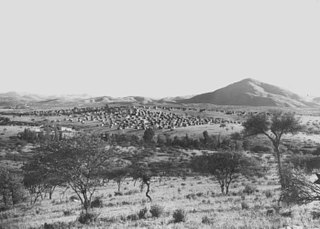
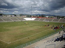
The Old Location was an area segregated for Black residents of Windhoek, the capital of Namibia. It was situated in the area between today's suburbs of Hochland Park and Pioneers Park.

German South West Africa was a colony of the German Empire from 1884 until 1915, though Germany did not officially recognise its loss of this territory until the 1919 Treaty of Versailles.
Otto Ferdinand Schimming was a Namibian teacher and early independence activist. He was the first black teacher in Namibia when he founded the Rietquelle School. A street in Katutura is named after him.
Moses Mague ǁGaroëb was a Namibian politician, founding member of SWAPO, and member of SWAPO's Politburo and Central Committee. During his political career, ǁGaroëb served in the Constituent Assembly of Namibia and was a Member of Parliament from the day of Namibian independence, 21 March 1990. He was appointed Minister of Labour and Human Resources in 1995, a position he held until his death.
Joseph Obgeb Jimmy was a Namibian diplomat. Jimmy was born in Windhoek's Old Location in 1951 and witnessed the forced removal of residents in December 1959 to the new suburb of Katutura.

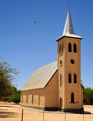
Franz Heinrich Kleinschmidt (1812–1864) was a German missionary and linguist who worked in southern Africa, now in the region of Namibia. He founded the missionary station and town of Rehoboth and together with Carl Hugo Hahn set up the first Rhenish mission station to the Herero people in Gross Barmen. Kleinschmidt is known for his scientific work on the Nama language.

Reverend Johann Heinrich Schmelen, born Johann Hinrich Schmelen was a German missionary and linguist who worked in South Africa and South-West Africa. Traveling through the area of today's northern South Africa and central and southern Namibia he founded the mission stations at Bethanie and Steinkopf and discovered the natural harbour at Walvis Bay. Together with his wife Zara he translated parts of the Bible into Khoekhoegowab (Damara/Nama) and published a dictionary.

Coloured people in Namibia are people with both European and African, especially Khoisan and Bantu ancestry, as well as Indian, Malay, and Malagasy ancestry especially along the coast and areas bordering South Africa. Coloureds have immigrated to Namibia, been born in Namibia or returned to the country. These distinctively different periods of arrivals, from diverse backgrounds and origins have led to a diverse Coloured population. This diversity was even further exploited by South African officials who referred to three distinct groups amongst the coloureds, namely: "Baster", "Cape Coloureds" and "Namibian Coloureds".

Aminuis is a cluster of small settlements in the remote eastern part of the Omaheke Region of Namibia, located about 500 km east of Windhoek. It is the district capital of the Aminuis electoral constituency.
The Augustineum Secondary School, established in 1866, is among the oldest schools in Namibia. Originally situated in Otjimbingwe, it was relocated to Okahandja in 1890, and finally to Windhoek in 1968. Previously also known as the Augustineum Training College and today the Augustineum Secondary School, it is a public school located in Khomasdal, a suburb of Windhoek.
Mburumba Kerina was a Namibian politician and academic. He was a co-founder of SWAPO, NUDO, and FCN, and the founder of a host of smaller political parties. For independent Namibia, he was a member of Namibia's Constituent Assembly, as well as the National Assembly and the National Council. Kerina coined the name "Namib" for the independent state "Namibia" on the territory of South West Africa.
St Barnabas was an Anglican mission station, church, and school in Windhoek, the administrative centre of South West Africa. The school was situated in the Old Location suburb. When Old Location was closed for blacks in 1968 the existing buildings and institutions, among them St Barnabas, were destroyed.