
A cave or cavern is a natural void in the ground, specifically a space large enough for a human to enter. Caves often form by the weathering of rock and often extend deep underground. The word cave can also refer to much smaller openings such as sea caves, rock shelters, and grottos, though strictly speaking a cave is exogene, meaning it is deeper than its opening is wide, and a rock shelter is endogene.

Hilo is a census-designated place (CDP) and the largest city in Hawaii County, Hawaii, United States, which encompasses the Island of Hawaiʻi. The population was 44,186 according to the 2020 census.

Kīlauea is an active shield volcano in the Hawaiian Islands. Historically, it is the most active of the five volcanoes that together form the Big Island of Hawaiʻi. Located along the southeastern shore of the island, the volcano is between 210,000 and 280,000 years old and emerged above sea level about 100,000 years ago. Its most recent eruption began on September 29, 2021.

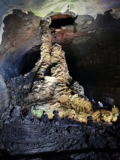
A lava tube, or pyroduct, is a natural conduit formed by flowing lava from a volcanic vent that moves beneath the hardened surface of a lava flow. If lava in the tube empties, it will leave a cave.
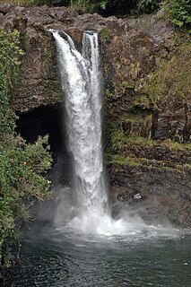
The Wailuku River is a 28.0-mile-long (45.1 km) water course on the Island of Hawaiʻi in the Hawaiian Islands. It is the longest river in Hawai'i and the largest in the state by mean discharge. Its course lies mostly along the divide between the lava flows of Mauna Kea and those of Mauna Loa to the south. It arises at about the 10,800 feet (3,300 m) elevation along the eastern slope of Mauna Kea. It flows generally eastward, descending steeply from the mountain and entering the Pacific Ocean at Hilo.

Route 200, known locally as Saddle Road, traverses the width of the Island of Hawaiʻi, from downtown Hilo to its junction with Hawaii Route 190 near Waimea. The road was once considered one of the most dangerous paved roads in the state, with many one-lane bridges and areas of marginally maintained pavement. Most of the road has now been repaved, and major parts have new re-alignments to modern standards. The highway is mostly one-lane in each direction, but there are two lanes on the uphill portions. The highway reaches a maximum elevation of 6,632 feet (2,021 m) and is subject to fog and low visibility. Many rental car companies used to prohibit use of their cars on Saddle Road, but now allow use of the road. The highway experiences heavy use as it provides the shortest driving route from Hilo to Kailua-Kona and access to the slopes of Mauna Loa and the Mauna Kea Observatories.

Kazumura Cave is a lava tube and has been surveyed at 40.7 miles long and 3,614 feet deep making it the longest and deepest lava tube in the world. The cave is located on the island of Hawaiʻi on the eastern slope of Kīlauea. Kīlauea is the most recently active volcano on the Big Island. The ʻAilāʻau lava flow that contains Kazumura Cave originated from the Kīlauea Iki Crater about 500 years ago.

Puna is one of the 9 districts of Hawaii County on the Island of Hawaiʻi. It is located on the windward side of the island and shares borders with South Hilo district in the north and Kaʻū district in the west. With a size of just under 320,000 acres (1,300 km2) or 500 sq. miles. Puna is slightly smaller than the island of Kauaʻi.

A show cave — also called tourist cave, public cave, and in the United States, commercial cave — is a cave which has been made accessible to the public for guided visits.

Papakōlea Beach is a green sand beach located near South Point, in the Kaʻū district of the island of Hawaiʻi. It is one of only four green sand beaches in the world, the others being Talofofo Beach, Guam; Punta Cormorant on Floreana Island in the Galapagos Islands; and Hornindalsvatnet, Norway. It gets its distinctive coloring from olivine sand eroded out of the enclosing volcanic cone.

Pōhakuloa Training Area (PTA) is located on the island of Hawaiʻi in the high plateau between Mauna Loa, Mauna Kea and the Hualālai volcanic mountains. It includes a small military airstrip known as Bradshaw Army Airfield.

Cueva del Viento is the largest lava tube system in Europe, and the sixth largest in the world, behind a series of lava tubes in Hawaii. It is also considered the most complex volcanic tube in the world, due to its morphology of several levels and passages.

Gruta das Torres, is a lava cave, a geological formation of volcanic origin formed from the flow and cooling of subterranean magma rivers. This formation is located outside the parish of Criação Velha, in the municipality of Madalena, on the western flanks of the island of Pico. The cave system formed from a series of pāhoehoe lava flows which originating from the Cabeço Bravo parasitic cone about 500 to 1500 years ago. The caves are a group of interconnected lava tubes between 0.5–22 metres (2–72 ft) width, created from both pāhoehoe and ʻaʻā types of lavas generated during different geological periods. It has a height between 1.1 and 15 metres (3.6–49 ft) and is located at an elevation of 300 metres (980 ft). With an estimated length of over 5.2 km (3.2 mi) it is the longest lava cave in the Azores. Access to the cave was managed by the Mountaineering Association. Starting in 2011, AZORINA, SA took over the management and organization of the cave.
The Manjanggul Lava Tube is located in Gimnyeong-ri, Gujwaeup, Jeju City. At up to 23m wide, 30m high and 8.928km long, it is the 12th-longest lava tube in the world and the second longest on Jeju island. It is regarded as having significant scientific and heritage value, owing to its excellent condition of preservation despite its age of formation.
The Cueva de Don Justo is one of approximately 70 caves and volcanic galleries on the island of El Hierro in the Canaries.
Leviathan Cave, also known as the Grotte de Leviathan, is a lava tube in eastern Kenya first discovered in 1975. Although it has been segmented by the movement of tectonic plates, the overall length of the lava tube spans a distance of 11.5 km. It is the longest and deepest known lava tube in Africa.

Waiākea-Uka (IPA:/'waj.ə.kei.ə.'u.kə/) is an ancient subdivision (ahupuaʻa) in the Hilo District of the Big Island of Hawaiʻi, located mauka (mountain-side) of the Waiākea ahupua'a; its location is on the lower flanks of the volcano Mauna Loa. Because of this, one meaning of the name 'Waiākea-Uka' can be translated from 'Olelo Hawai'i as '(the) mountain-side (of) Waiākea'. Many ahupua'a have this -uka appellation, as the directions 'mountain-side' and 'sea-side' (makai) are the two best ways of orientating something in space on any of the islands.
The ʻAilāʻau eruption is a prehistoric eruption of Kīlauea volcano on the island of Hawaiʻi in the Hawaiian Islands. Carbon 14 dated from approximately 1410 to 1470 with an eruptive volume of 5.2 ± 0.8 km3 and fed by lava tubes near Kīlauea Iki crater, it was among the last of a series of highly voluminous lava flows since about 1290 that blanketed vast swaths of what is now Hawaii County's Puna District. The Kazumura Cave lava tubes were also created by this eruption. The ʻAilāʻau eruption occurred before written records, but was witnessed by Ancient Hawaiians, and through their oral traditions it is thought to have inspired the Hawaiian myth of ʻAilāʻau, whose name in the Hawaiian language means "forest-eater" in reference to the many forest lands consumed by lava.

Hele-On Bus is the public transport bus service provided by the County of Hawaii on the Big Island, Hawaii, United States. It serves a limited number of routes on limited frequency.

