Keitum

Last updated

Keitum
KeitumFriesenhaus1784.jpg
18th-century Friesenhaus in Keitum
Location of Keitum
Keitum
Germany adm location map.svg
Red pog.svg
Keitum
Germany Schleswig-Holstein adm location map.svg
Red pog.svg
Keitum
Coordinates: 54°36′N8°22′E / 54.600°N 8.367°E / 54.600; 8.367 Coordinates: 54°36′N8°22′E / 54.600°N 8.367°E / 54.600; 8.367
Country Germany
State Schleswig-Holstein
District Nordfriesland
Town Gemeinde Sylt
Time zone UTC+01:00 (CET)
  Summer (DST) UTC+02:00 (CEST)
Dialling codes 04651
Vehicle registration NF
Website www.gemeinde-sylt.de

Keitum (Danish: Kejtum, North Frisian: Kairem) is a village on the North Sea island of Sylt in the district of Nordfriesland in Schleswig-Holstein, Germany. Today, it is an Ortsteil of the Gemeinde Sylt .

Contents

Etymology

It is unclear from what the name Keitum (Kairem in North Frisian, Kejtum in Danish) is derived. One theory posits that it used to refer to the "home of Kei" or "home of Keit". Alternatively, it could be based on "Heidum" (auf der Heide or "on the heath"). [1] :189

History

"Keytum" was first mentioned in 1462. Until the end of the 19th century, Keitum was the most important town on the island of Sylt. Since 1612 it was the location of Sylt's largest mill. In 1695, the village had 78 houses. A school house was built in 1763. In 1820, the harbour was expanded. Although keeping the navigation channel open was a continuing problem, Keitum harbour was the main connection between Sylt and the mainland until around 1867. After 1859, the harbour silted up and the ferry traffic shifted to Munkmarsch. In 1860, Keitum had passed Morsum as the island's most populous village (with 785 inhabitants). In the 1890s, the tourist business moved increasingly to Westerland, sidelining the eastern villages. Although Keitum is located on the railway which connected Westerland with Niebüll via the Hindenburgdamm in 1927, most visitors disembarked only at the line's terminus, at Westerland. [1] :189–190

Geography

Keitum is located on the Wadden Sea side of the island. The village fronts on the sea at what is called the Grünes Kliff  [ de ] (green cliff), a mostly vegetation-covered (hence green) escarpment. [1] :189 It stretches along the coast for around 3 kilometres from the eastern edge of the village to the church of St. Severin, north of the village.

Demographics

In 2013, Keitum had a permanent population of around 880. Another 900 people have second homes in the village. [1] :188–189

Economy

Like elsewhere on Sylt, tourism is a major industry. Since 1950, the village has held the status of Luftkurort (climatic spa). Keitum is known for its large number of traditional Uthland-Frisian houses, many of them over 200 years old, and its tree-lined avenues. Although the original elm trees died in the 1990s, they have been replaced by chestnut and linden trees. In addition, many craftspeople (like gold smiths, weavers and potters) are based in Keitum. [1] :189–190

Attractions

St. Severin

St. Severin Severinskirche Keitum.jpg
St. Severin

Originally built in the early 13th century, this Romanesque church is today thought to be the oldest in Schleswig-Holstein. It was originally dedicated to the saints Canute and Ketel, but later rededicated to Severin of Cologne. [1] :330

The attached graveyard holds the graves of numerous important local families (especially whalers and other owners or masters of ships) and of some notable people: Rudolf Augstein, Gerhard Schröder, Uwe Dallmeier  [ de ], Peter Suhrkamp and Ernst Mollenhauer  [ de ]. Several works of sculpture art have also been erected in the churchyard. [1] :332

Harhoog

The megalithic tomb Megalithic grave Harhoog in Keitum, Sylt, Germany.jpg
The megalithic tomb

A megalithic tomb, moved to its present location on the edge of Keitum in 1954 from its original position between Keitum and Tinnum, due to the construction of Sylt Airport. [1] :147

Located next to Harhoog is the Bronze Age tumulus Tipkenhoog. Excavations of the mound in 1870 failed to locate any contents. In World War II, an observation post was situated on the hill, damaging the site. [1] :396

Further attractions

Table at the Cliff "Tisch am Kliff" zum Thema "5000 Jahre Sylter Geschichte" 2019 aufgestellt am Sylt Museum in Keitum auf Sylt.jpg
Table at the Cliff

Keitum has three museums: Altfriesische Haus, Sylt Museum and the Feuerwehrmuseum. The former is a house built in 1739 and mostly retains period furniture and accessoires, exhibiting 18th century home decor and living styles. The Sylt Museum is located in a house dating from 1759 and features exhibits on local history and regional living conditions in the past. [2] [3] [4] The Table at the Cliff, created in bronze by five artists in 2019 on the subject of 5000 years of Sylt history is situated at the Sylt Museum. [5]

Government

In the Gebietsreform of 1970, Keitum became part of the newly created municipality Sylt-Ost. It used to be the seat of Sylt-Ost's municipal administration and also of that of the Amt Landschaft Sylt . Sylt-Ost was merged on 1 January 2009 with Rantum and the town of Westerland. In separate referendums in 2008, Westerland (by a large majority) and Sylt-Ost (narrowly) agreed to the merger in May 2008. Rantum followed. In September 2008, the merger contract was signed. [6] [1] :16

Keitum is now an Ortsteil of Gemeinde Sylt. Since 1 May 2015, the mayor of Gemeinde Sylt has been Nikolas Häckel. The administrations of both Gemeinde Sylt and Landschaft Sylt are today located in Westerland.

Infrastructure

Transport

Keitum has a railway station on the line between Westerland and Niebüll. However, long-distance trains and the Sylt Shuttle do not stop there. But hourly, there is a direct connection by train to Hamburg-Altona.

Notable people

Related Research Articles

Sylt German island in the North Sea

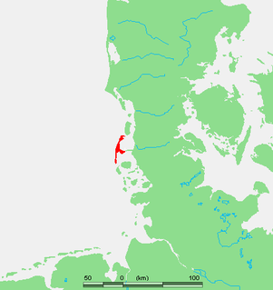
Sylt is an island in northern Germany, part of Nordfriesland district, Schleswig-Holstein, and well known for the distinctive shape of its shoreline. It belongs to the North Frisian Islands and is the largest island in North Frisia. The northernmost island of Germany, it is known for its tourist resorts, notably Westerland, Kampen and Wenningstedt-Braderup, as well as for its 40-kilometre-long (25-mile) sandy beach. It is frequently covered by the media in connection with its exposed situation in the North Sea and its ongoing loss of land during storm tides. Since 1927, Sylt has been connected to the mainland by the Hindenburgdamm causeway. In later years, it has been a resort for the German jet set and tourists in search of occasional celebrity sightings.

North Frisian Islands

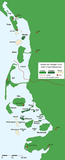
The North Frisian Islands are the Frisian Islands off the coast of North Frisia.

Westerland, Germany Ortsteil of Gemeinde Sylt in Schleswig-Holstein, Germany

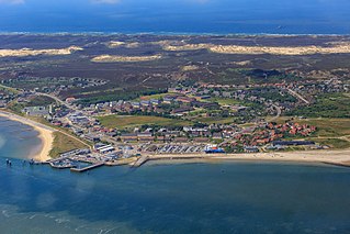
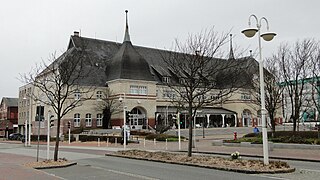
Westerland is a seaside resort and a former municipality located on the German North Sea island of Sylt. Since 1 January 2009, Westerland has been part of the municipality Gemeinde Sylt. Westerland is part of the Nordfriesland district in Schleswig-Holstein. It is the largest resort on the island, the local transportation hub and the centre of Sylt's tourist industry.

Landschaft Sylt Amt in Germany

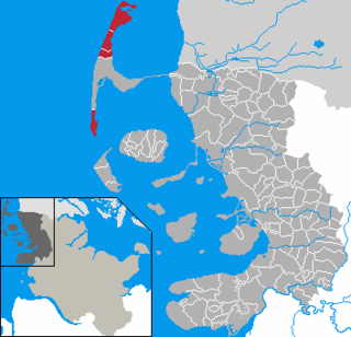
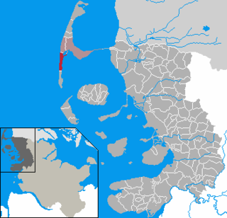
Landschaft Sylt is an Amt in the district of Nordfriesland, in Schleswig-Holstein, Germany. It covers the island of Sylt, in the North Sea, about 65 km northwest of Husum. Its administrative seat is in the town Westerland - which is not, however, a part of the Amt.

Hindenburgdamm

The Hindenburgdamm or Hindenburg Dam is an 11 km-long causeway joining the North Frisian island of Sylt to mainland Schleswig-Holstein. Its coordinates are 54°53′N8°33′E. It was opened on 1 June 1927 and is exclusively a railway corridor. The companies that built the Hindenburgdamm, a job that took four years, were Philipp Holzmann AG of Frankfurt, working from the mainland, and Peter Fix Söhne of Duisburg working from Sylt. A train trip along the causeway takes about 10 minutes, and the time between the auto terminals at Niebüll on the mainland and Westerland on Sylt is about 30 minutes. The Hindenburgdamm is part of the railway line known as the Marschbahn, which is double-tracked along much of the route, although there as yet exists a single-tracked stretch. On the causeway is a signal box.

List on Sylt Municipality in Germany

List auf Sylt is the northernmost municipality in Germany, located on the North Sea island of Sylt close to Denmark in the district of Nordfriesland in the state of Schleswig-Holstein.

Hörnum Municipality in Schleswig-Holstein, Germany

Hörnum  is a municipality in the district of Nordfriesland, in Schleswig-Holstein, Germany. It is located on the southern headland of the island of Sylt. The municipality is part of the Amt Landschaft Sylt. The economy is dominated by tourism.

Kampen (Sylt) Municipality in Schleswig-Holstein, Germany

Kampen  is a municipality and seaside resort on the island Sylt, in the district of Nordfriesland, in Schleswig-Holstein, Germany. It is located north of the island's main town, Westerland. The municipality is part of the AmtLandschaft Sylt. The local economy is dominated by tourism.

Rantum Ortsteil of Sylt in Schleswig-Holstein, Germany

Rantum is a village and a former municipality on the island of Sylt in the district of Nordfriesland, in Schleswig-Holstein, Germany. Since 1 January 2009, it has been an Ortsteil (part) of the municipality Sylt.

Wenningstedt-Braderup Municipality in Schleswig-Holstein, Germany

Wenningstedt-Braderup is a municipality and seaside resort on the island of Sylt in the district of Nordfriesland, in Schleswig-Holstein, Germany. It is located north of the town of Westerland and is part of the Amt Landschaft Sylt. The local economy is dominated by tourism.

Sylt-Ost Municipality in Schleswig-Holstein, Germany

Sylt-Ost is a former municipality on the island of Sylt, in the district of Nordfriesland, in Schleswig-Holstein, Germany. It used to be the administrative seat of the Amt Landschaft Sylt and a municipality into which a number of villages had been amalgamated in 1970. However, following a referendum in May 2008, Sylt-Ost merged with Westerland and Rantum to form the collective municipality Gemeinde Sylt which was created on 1 January 2009. Since 2009, the seat of the Amt Landschaft Sylt has been in Westerland.

Sylt (municipality) Municipality in Schleswig-Holstein, Germany

Gemeinde Sylt is a municipality on the island of Sylt in the district of Nordfriesland, in Schleswig-Holstein, Germany. It has around 13,000 inhabitants and covers about 60% of the area of the island.

Marsh Railway

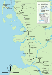
The Marsh Railway is a main line in the state of Schleswig-Holstein in Germany that links the stations of Elmshorn in the south and Westerland on the island of Sylt in the north. It is part of 237-kilometre long (147 mi) through route from Hamburg-Altona to Westerland (Sylt) and is listed in the Deutsche Bahn timetables as Kursbuchstrecke 130. The first part of it was opened in 1845 and is one of the oldest lines in Germany.

Sylt may refer to:

Eidum or Eydum was a historic place on the German island of Sylt in the North Sea. It was several hundred metres west of the present coast line of the present-day village of Westerland.

Archsum Ortsteil of Gemeinde Sylt in Schleswig-Holstein, Germany

Archsum is a village on the North Sea island of Sylt in the district of Nordfriesland in Schleswig-Holstein, Germany. Today, it is an Ortsteil of the Gemeinde Sylt.

Morsum Ortsteil of Gemeinde Sylt in Schleswig-Holstein, Germany

Morsum is a village on the North Sea island of Sylt in the district of Nordfriesland in Schleswig-Holstein, Germany. Today, it is an Ortsteil of the Gemeinde Sylt. Morsum is located close to the scientifically important geotope Morsum-Kliff and to the beginning of the Hindenburgdamm linking Sylt with the mainland.

Munkmarsch Ortsteil of Gemeinde Sylt in Schleswig-Holstein, Germany

Munkmarsch is a village on the North Sea island of Sylt in the district of Nordfriesland in Schleswig-Holstein, Germany. Today, it is an Ortsteil of the Gemeinde Sylt.

Tinnum Ortsteil of Gemeinde Sylt in Schleswig-Holstein, Germany

Tinnum is a village on the North Sea island of Sylt in the district of Nordfriesland in Schleswig-Holstein, Germany. Today, it is an Ortsteil of the Gemeinde Sylt.

Ingo Kühl German artist, draughtsperson and painter

Ingo Kühl is a German painter, sculptor and architect.

References

  1. 1 2 3 4 5 6 7 8 9 10 Kunz, Harry; Steensen, Thomas (2014). Taschenlexikon Sylt (German). Wachholtz. ISBN   978-3-529-05525-6.
  2. "Altfriesisches Haus (Sylt) (German)". Museen in SH. Retrieved 30 April 2015.
  3. "Altfriesisches Haus (German)". Gemeinde Sylt. Retrieved 30 April 2015.
  4. "Sylter Heimatmuseum (German)". Gemeinde Sylt. Retrieved 30 April 2015.
  5. "Tisch am Kliff". www.gemeinde-sylt.de. 18 June 2019.
  6. "Die Metropole der Insel heißt jetzt Sylt (German)". Hamburger Abendblatt. Retrieved 7 April 2015.