Kermanshah Province Persian: استان کرمانشاه | |
---|---|
Coordinates: 34°33′N46°43′E / 34.550°N 46.717°E | |
Country | Iran |
Region | 4th Region |
Capital | Kermanshah |
Counties | 14 |
Government | |
• Governor-general | Mohammad-Tayyeb Sahraee |
• MPs of Assembly of Experts | Aman Narimani and Mohammad Mohammadi Araghi |
• Representative of the Supreme Leader | Mostafa Olama |
Area | |
• Total | 24,998 km2 (9,652 sq mi) |
Population (2016) [1] | |
• Total | 1,952,434 |
• Density | 78/km2 (200/sq mi) |
Demonym | Kermanshahi |
Time zone | UTC+03:30 (IRST) |
ISO 3166 code | IR-05 |
Main language(s) | Kurdish local Persian official [2] [3] |
HDI (2017) | 0.796 [4] high · 14th |
Year | Pop. | ±% |
---|---|---|
1996 | 1,778,596 | — |
2006 | 1,879,385 | +5.7% |
2011 | 1,945,227 | +3.5% |
2016 | 1,952,434 | +0.4% |
amar.org.ir |
Kermanshah Province (Persian : استان كرمانشاه, romanized: Ostân-e Kermânšâh, Kurdish : پارێزگای کرماشان, romanized: Parêzgeha Kirmaşan [5] [6] ) is one of the 31 provinces of Iran and one of the provinces which border Iraq. The province was known from 1969 to 1986 as Kermanshahan, and from 1986 to 1995 as Bakhtaran (Persian : استان باختران). [7] The capital of the province is the city of Kermanshah. According to a 2014 segmentation by the Ministry of Interior, it is the center of Region 4, [8] with the region's central secretariat located in Kermanshah. A majority of people in Kermanshah Province are Shia, and there are Sunni and Yarsani minority groups. [9] [10] [11]
At the time of the National Census conducted in 2006, the population of Kermanshah province was 1,842,457 in 444,185 households. [12] By the time of the following census in 2011, there were 1,945,227 people in 530,911 households. [13] At the latest census in 2016, Kermanshah had a population of 1,952,434 in 576,861 households. [1]
Kermanshah province is located in western Iran. It shares borders with the provinces of Kurdistan, Hamadan, Lorestan, and Ilam within Iran. [14] It also shares borders with the Iraqi governorates of Halabja, Sulaymaniyah and Diyala. [15] Major cities and towns besides the capital include Eslamabad-e Gharb, Gilan-e Gharb, Harsin, Javanrud, Kangavar, Paveh, Qasr-e Shirin, Ravansar, Sahneh, Sarpol-e Zahab, and Sonqor.
As it is situated between two cold and warm regions, Kermanshah province enjoys a moderate and mountainous climate. It rains most in winter and is moderately warm in summer. The annual rainfall is 500 mm. The average temperature in the hottest months is above 22 °C.[ citation needed ]
The province has a rich Paleolithic heritage. Many caves with Paleolithic remains have been surveyed or excavated there. some of these cave sites are located in Bisetun and north of Kermanshah. The first known physical remains of Neanderthal man in Iran was discovered in Bisitun Cave. Do-Ashkaft Cave, Kobeh, Warwasi, and Mar Tarik are some of the Middle Paleolithic sites in the region. Kermanshah also has many Neolithic sites, of which the most well-known are Ganj Dareh, Sarab, and Asiab. At Ganj Dareh, the earliest evidence for goat domestication have been documented. In May 2009, based on a research conducted by the University of Hamedan and UCL, the head of Archeology Research Center of Iran's Cultural Heritage and Tourism Organization announced that the oldest prehistoric village in the Middle East dating back to 9800 B.C., was discovered in Sahneh, located in west of Kermanshah. [16] [17]
The monuments found in Kermanshah show two glorious periods, the Achaemenid and Sassanid eras. The mythical ruler of the Pishdadian is described as founding the city while Tahmores Divband built it. An alternative narrative is that the construction was by Bahram IV of the Sassanid dynasty during the 4th century CE. Kermanshah reached a peak during the reign of Hormizd IV and Khosrau I of Sassanids, before being demoted to a secondary royal residence.
The city suffered major damage during the Arab invasions but recovered in the Safavid period to make great progress. Concurrent with the Afghan attack and the fall of Isfahan, Kermanshah was almost completely destroyed by the Ottoman invasion.
During the Iran–Iraq War the province suffered heavy fighting. Most towns and cities were badly damaged and some like Sar-e Pol-e Zahab and Qhasr-e-Shirin were almost completely destroyed.
The November 2017 Iran–Iraq earthquake killed more than 600 people.
On 28 December 2017, Kermanshah became one of several Iranian provinces to break out into protests. The Supreme Leader of Iran has blamed western interference. Some female organizations such as The National Council of Resistance of Iran (NCRI) have taken partial credit for the organization of these protests. [18] [19]
Administrative Divisions | 2006 [12] | 2011 [13] | 2016 [1] |
---|---|---|---|
Dalahu County | 42,310 | 39,837 | 35,987 |
Eslamabad-e Gharb County | 149,376 | 151,473 | 140,876 |
Gilan-e Gharb County | 60,671 | 62,858 | 57,007 |
Harsin County | 90,452 | 86,342 | 78,350 |
Javanrud County | 62,259 | 71,235 | 75,169 |
Kangavar County | 80,215 | 81,051 | 76,216 |
Kermanshah County | 950,400 | 1,030,978 | 1,083,833 |
Paveh County | 51,755 | 56,837 | 60,431 |
Qasr-e Shirin County | 19,821 | 25,517 | 23,929 |
Ravansar County | 44,983 | 46,395 | 47,657 |
Sahneh County | 75,827 | 76,678 | 70,757 |
Salas-e Babajani County | 37,056 | 38,475 | 35,219 |
Sarpol-e Zahab County | 81,428 | 85,616 | 85,342 |
Sonqor County | 95,904 | 91,935 | 81,661 |
Total | 1,842,457 | 1,945,227 | 1,952,434 |
According to the 2016 census, 1,468,615 people (over 75% of the population of Kermanshah province) live in the following cities: Banevreh 3,187, Bayangan 1,513, Bisotun 4,942, Eslamabad-e Gharb 90,559, Ezgeleh 1,502, Gahvareh 4,050, Gilan-e Gharb 22,331, Gowdin 2,629, Halashi 804, Harsin 44,146, Homeyl 1,317, Javanrud 54,354, Kangavar 51,352, Kerend-e Gharb 7,798, Kermanshah 946,651, Kuzaran 4,007, Miyan Rahan 695, Nowdeshah 3,683, Nowsud 1,949, Paveh 25,771, Qasr-e Shirin 18,473, Ravansar 24,527, Robat 823, Sahneh 35,508, Sarmast 2,913, Sarpol-e Zahab 45,481, Satar 1,048, Shahrak-e Rijab 3,907, Shahu 3,558, Sonqor 44,256, Sumar 180, and Tazehabad 14,701. [1]
The province's capital is Kermanshah, located in the middle of the western part of Iran. The population of the city is 946,651 as of 2016. [1] It is built on the slopes of Mt. Sefid Kooh and extended toward south during last two decades. The built-up areas run alongside Sarab River and Sarab Valley. The city's elevation averages about 1,350 meters above sea level.[ citation needed ]
The distance between Kermanshah and Tehran is 525 km. It is the trade center of rich agricultural region that produces grain, rice, vegetable, fruits, and oilseeds, and there are many industrial centers, oil and sugar refineries, and cement, textile and flour factories, etc. The airport (Shahid Ashrafi Esfahani Airport) is located in north east of the city, and the distance from Tehran is 413 km by air.
Kermanshah province has 371 km of common border with Iraq.There are five official border markets in the province. Three of these neighbor the Kurdish part of Iraq and the other two the Iraqi central government (Khosravi, Sumar). Based on figures from 9 November 2021, with a share of 5.7 to 6 percent Kermanshah province is among the first five exporters of non-oil products of Iran. Around 30 to 35 percent of theses exports were from the province's own products. The highest share of exports belong to Parviz border which neighbors Iraqi Kurdistan followed by Khosravi and Sumar. [20] [21]
Exports from Kermanshah Province hit $2.7 billion in the fiscal year 2021-22 (ending 20 March), registering a 15% growth compared with the previous year, according to a local official.
The province's share in Iran's total exports during the period stood at 10% in terms of tonnage and 12% in value.
Kermanshah's share in total exports to Iraq stood at 53% and share in non-oil goods reached 43%.
Non-oil exports from Kermanshah mainly include tomato and tomato paste, air conditioners, cheese, industrial oil and their derivatives, biscuit, different types of melon, watermelon, tile and ceramic, plastic bags, marble, yogurt, milk, cream, cucumber, eggplant, apple and melamine dishes. [21]
Kermanshah lends its name to a type of Persian carpet named after the region. It also has famous sweets made of rice, locally known as Nan-e berenji. [22] The other famous Kermanshahi good is a special kind of oil, locally known as Rüne Dân and globally in Iran known as Roghan Kermanshahi. The Giveh of Kermanshah known as Klash is the highest quality Giveh.
Various attractions exist that date from the pre-Islamic era, such as the Kohneh Bridge, to contemporary parks and museums. Some of the more popular sites are:
Kermanshah province is one of those provinces of Iran where different ethnic and religious groups live. Kurds, Persian speakers, Lurs, Arabs are among the most important ethnic groups that live in this province. Another anthropological feature of this province is the presence of followers of different religions such as Shiites, Sunnis and Yarsans in this province. [25] [26] [27]
One of the renowned scientists and writers of this region is Al-Dinawari who was born at Dinawar north-east of Kermanshah. He lived in the 9th century and has written many books in astronomy, botany and history. Notable people born in Kermansha include British author, Nobel prize winner, Doris Lessing, whose father, a British Army officer, was stationed there at the time of her birth. Mirza Ahmad Khan Motazed-Dowleh Vaziri created the first printing office and founded the first private school of Kermanshahan. Guity Novin a painter and a graphic designer who has founded the Transpressionism movement was born in Kermanshah. The famous Sufi Scholar, Abdul Qader Gailani, was born in the region.
Tehran province is one of the 31 provinces of Iran. It covers an area of 18,814 square kilometres (7,264 sq mi) and is located to the north of the central plateau of Iran.
Ilam Province is one of the 31 provinces of Iran. It is located in the western part of the country in Region 4 and covers 20,164.11 km2 (7,785.41 sq mi). It shares 425 km (264 mi) of the border with Iraq, and also bordering on the provinces of Kermanshah, Lorestan, and Khuzestan. The largest city and also the provincial capital is Ilam.
Khuzestan province is one of the 31 provinces of Iran. Located in the southwest of the country, the province borders Iraq and the Persian Gulf. Its capital is Ahvaz and it covers an area of 63,238 square kilometres (24,416 sq mi). Since 2014, it has been part of Iran's Region 4.
Kurdistan or Kordestan province is one of the 31 provinces of Iran. The province is 28,817 km2 in area and its capital is the city of Sanandaj. Other counties with their major cities are Saqqez, Baneh, Marivan, Qorveh, Bijar, Kamyaran, Dehgolan, Diwandarreh and Sarvabad.
Laki is a vernacular that consists of two dialects; Pish-e Kuh Laki and Posht-e Kuh Laki. Laki is considered a Kurdish dialect, by most linguists and is spoken chiefly in the area between Khorramabad and Kermanshah in Iran by about 680,000 native speakers.
Kermanshah, is the capital of Kermanshah Province, located 525 kilometres from Tehran in the western part of Iran. According to the 2016 census, its population is 946,651.
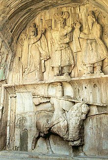
Taq-e Bostan is a site with a series of large rock reliefs from the era of the Sassanid Empire of Persia (Iran), carved around the 4th century CE.
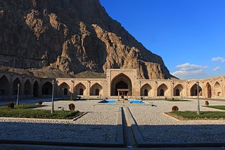
The Anahita Temple is the name of one of two archaeological sites in Iran popularly thought to have been attributed to the ancient Iranian deity Anahita. The larger and more widely known of the two is located at Kangāvar in Kermanshah Province. The other is located at Bishapur.
Kurds in Iran constitute a large minority in the country with a population of around 9 and 10 million people.
Kangavar, also Romanized as Kangāvar, is a city in the Central District of Kangavar County, Kermanshah province, Iran, serving as capital of both the county and the district.
Qasr-e Shirin also Romanized as Qasr-e Širin and Qasr-e-Shīrīn; also known as Ghasr-ī-Shīrīn and Ghasr-Shīrīn; Kurdish: قەسری شیرین, romanized: Qesrî Şîrîn, is a city in the Central District of Qasr-e Shirin County, Kermanshah province, Iran, serving as capital of both the county and the district. Its population in 2016 was 18,473. It is a Free-trade zone (FTZ) and is populated by Kurds.
Bisotun, also Romanized as Bīsotūn; also known as Bīsītan and Bīsītūn, is a city in, and the capital of, Bisotun District of Harsin County, Kermanshah province, Iran. It also serves as the administrative center for Chamchamal Rural District.
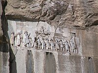
Behistun palace is a ruined Sassanid palace located in Bisotun, 20 kilometres (12 mi) from Kermanshah, Iran. It faces the cliff with the much older Behistun inscription and rock relief, across the ancient road running between Behistun mountain and Behistun lake. The palace has long been regarded in Persian tradition as a residence of Shirin, queen of Khosrau II, the Sassanid Shah of Persia who reigned from 590 to 628, shortly before the Muslim conquest of Persia. This connection is first documented, in surviving records, by early Islamic geographers, and is elaborated in various later stories and myths, as a fictionalized Shirin became an important heroine of later Persian literature, such as the Shahnameh. It is included in the UNESCO World Heritage Site of Bisotun.
Khosravi, also Romanized as Khosravī and Khosrovī; also known as Khosrowvī, Khūsrawī, and Khūsrovī, is a village in, and the capital of, Alvand Rural District of the Central District of Qasr-e Shirin County, Kermanshah province, Iran. The village is populated by Kurds.
The Anubanini petroglyph, also called Sar-e Pol-e Zohab II or Sarpol-i Zohab relief, is a rock relief from the Akkadian Empire period or the Isin-Larsa period and is located in Kermanshah Province, Iran. The rock relief is believed to belong to the Lullubi culture and is located 120 kilometers away from the north of Kermanshah, close to Sarpol-e Zahab. Lullubi reliefs are the earliest rock reliefs of Iran, later ones being the Elamite reliefs of Eshkaft-e Salman and Kul-e Farah.
Zangana is a Kurdish tribe in Kermanshah province and some parts of Iraqi Kurdistan. They speak a distinct dialect. However, in recent years they have linguistically assimilated into the language practice of Sorani speakers in the area in which they live.
On 12 November 2017 at 18:18 UTC, an earthquake with a moment magnitude of 7.3 occurred on the Iran–Iraq border, with the Iraqi Kurdish city of Halabja, and the Kurdish dominated places of Ezgeleh, Salas-e Babajani County, Kermanshah Province in Iran, closest to the epicentre, 30 kilometres (19 mi) south of the city of Halabja, Iraqi Kurdistan.
Kameel Ahmady is a British-Iranian scholar working in the field of social anthropology, with a particular focus on gender, children, ethnic minorities, and child labour. Kameel Ahmady, born in 1972 in Naghadeh, West Azerbaijan Province, is an Iranian-British researcher and social anthropologist known for his research and activities in the fields of social anthropology and harmful traditional practices. He is the coordinator and developer of more than 11 research study books and 20 scientific articles in Persian, English, Turkish, and Kurdish on subjects such as child marriage, temporary marriage, White marriage, female genital mutilation/cutting (FGM/C), Male circumcision, child labour and children's scavenging, LGBTQ+ issues and identity and ethnicity.
Rahahane Gharb or Iran's west railway is a partially finished railway corridor in western Iran.
Kermanshah Nabi Akram Corps is a military unit under IRGC and Basij. Their headquarters are located in Kermanshah, and they are the main unit in Kermanshah and are responsible for commanding all Corps and Basij units located in Kermanshah province.
{{cite journal}}
: Cite journal requires |journal=
(help)