
Limerick is a city in County Limerick, Ireland. It is located in the Mid-West Region and is also part of the province of Munster. With a population of 94,192 at the 2016 census, Limerick is the third-most populous urban area in the state, and the fourth-most populous city on the island of Ireland at the 2011 census. The city lies on the River Shannon, with the historic core of the city located on King's Island, which is bounded by the Shannon and Abbey Rivers. Limerick is also located at the head of the Shannon Estuary, where the river widens before it flows into the Atlantic Ocean. Limerick City and County Council is the local authority for the city.

The River Shannon is the longest river in the Republic of Ireland and on the island of Ireland at 360.5 km. It drains the Shannon River Basin which has an area of 16,865 km2 (6,512 sq mi), one fifth of the area of the island.

County Limerick is a county in Ireland. It is located in the province of Munster, and is also part of the Mid-West Region. It is named after the city of Limerick. Limerick City and County Council is the local council for the county. The county's population at the 2016 census was 194,899 of whom 94,192 lived in Limerick City, the county capital.

Ireland is an island in Northwestern Europe in the north Atlantic Ocean. The island lies on the European continental shelf, part of the Eurasian Plate. The island's main geographical features include low central plains surrounded by coastal mountains. The highest peak is Carrauntoohil, which is 1,041 meters (3,415 ft) above sea level. The western coastline is rugged, with many islands, peninsulas, headlands and bays. The island is bisected by the River Shannon, which at 360.5 km (224 mi) with a 102.1 km (63 mi) estuary is the longest river in Ireland and flows south from County Cavan in Ulster to meet the Atlantic just south of Limerick. There are a number of sizeable lakes along Ireland's rivers, of which Lough Neagh is the largest.

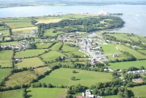
Foynes is a town and major port in County Limerick in the midwest of Ireland, located at the edge of hilly land on the southern bank of the Shannon Estuary. The population of the town was 520 as of the 2016 census.

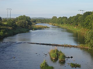
Askeaton, is a town in County Limerick, Ireland. The town on the N69, the road between Limerick and Tralee, is built on the banks of the River Deel some 3 km upstream from the estuary of the River Shannon.
Waterford Harbour is a natural harbour at the mouth of the Three Sisters; the River Nore, the River Suir and the River Barrow in Ireland. It is navigable for shipping to both Waterford and New Ross. The Port of Waterford is capable of accommodating vessels up to 32,000 tons dwt. It separates County Waterford from County Wexford on the eastern side of the estuary.

Fenit is a small village in County Kerry, Ireland, located on north side of Tralee Bay about 10 km (6 mi) west of Tralee town, just south of the Shannon Estuary. The bay is enclosed from the Atlantic by the Maharee spit which extends northwards from the Dingle peninsula. Fenit harbour is a mixed function sea port, where fishing, freight import and export, and a 136 berth marina are the main forms of business. The population was 527 in the 2011 CSO census compared to 427 in 2006.
The River Feale rises near Rockchapel in the Mullaghareirk Mountains of County Cork in the southwest of Ireland and flows northwestwards for 75 kilometres through Abbeyfeale in County Limerick and Listowel in County Kerry before finally emptying into Cashen Bay, a wide estuary north of Ballyduff. Then it flows out through the Shannon's estuary and joins with the Atlantic Ocean with a flow rate of 34.6 m2/s. The river, along with its tributaries, combine to add to over 160 km of waterways. For the final 10km stretch it is known as the Cashen River. The river contains a large salmon and sea trout population.
Dingle Bay is a bay located in County Kerry, western Ireland. The outer parts of the Dingle Peninsula and Dingle Bay mark one of the westernmost points of mainland Ireland. The harbour town of Dingle lies on the north side of the bay.
Tarbert is a town in the north of County Kerry, with woodland to the south and the Shannon estuary to the north. It lies on the N69 coast road that runs along the estuary from Limerick before turning inland at Tarbert towards Listowel, and has two schools Tarbert Primary and Tarbert Comprehensive.

Tralee Bay is located in on the west coast of County Kerry, Ireland. It is situated between Kerry Head on the north side and the Maharees on the west and extends eastwards as far as the bridge at Blennerville. Several small rivers feed into the bay through the town of Tralee. Villages around the bay include; Ballyheigue, Fenit, Kilfinora, Spa, Blennerville, Camp and Castlegregory.
Kilrush Marina is a locked marina in Kilrush Harbour, Kilrush, County Clare, Ireland. It has a well equipped marina services building, with an extensive boatyard, including a large indoor boat storage and repair facility. Many boats from other leisure boating centres on the West Coast of Ireland winter in Kilrush. Originally funded by Shannon Development the marina has grown to be an integral part of the local economy. The marina is used as a base for day trips to Scattery Island and for Dolphin Watch cruises.

Loop Head, is a headland on the north side of the mouth of the River Shannon, in County Clare in the west of Ireland.
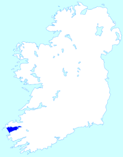
The Shannon Estuary is a large estuary where the River Shannon flows into the Atlantic Ocean. The estuary has Limerick City at its head and its seaward limits are marked by Loop Head to the north and Kerry Head to the south. The estuary defines the main boundary between County Kerry/County Limerick to the south and County Clare to the north.

The River Fergus is a river within the Shannon River Basin which flows in County Clare, Ireland. The river begins at Lough Fergus in north Clare and flows into the Shannon Estuary. The source is at Lough Fergus in the townland of Kilmore North. At Knockroe, the river is joined by a tributary stream called the Clooneen River. The Fergus flows underground for about a kilometre in Cahermacon, near Kilnaboy. The river then flows through Lough Inchiquin. Just after this lake, a tributary which has its source at Loughnagowan joins the Fergus. The river then flows along by the village of Corofin. After Corofin, the river flows through Lough Atedaun, Ballyteige Lough, Dromore Lake and Ballyallia Lake. The river then flows through the town of Ennis, where it is crossed by six road bridges, a pedestrian bridge and a railway bridge. There is also a small branch which splits off just north of Ennis and rejoins the main flow to the east of the town. Another tributary, a stream known as the Inch River or Claureen River, also joins at Ennis. The river then flows through the village of Clarecastle, where there was a port in former times. After Clarecastle, the river widens into an estuary which then joins the Shannon Estuary. There are several islands in the Fergus Estuary, including Deer Island, Coney Island, Trummer Island, Inishmacowney, Canon Island and Inishloe. Some of these islands were once inhabited, and there were schools on Coney Island and Inishloe.
Ireland is an island surrounded by water, with a 7,500 kilometres (4,700 mi) coastline. This list catalogues about 400 of the coastal landforms of the island including bays, estuaries, harbours, headlands, and many others. Most offshore features such as islands, stags (stacks), and rocks are omitted but are presented at List of islands of Ireland. A list of beaches is available at List of beaches in Ireland.

Aughinish is a former island in the Shannon estuary, in County Limerick, Ireland, near Foynes.
Shannon Foynes Port is a port operating company managing the operations of cargo facilities within the Shannon Estuary. It is the second largest port in Ireland. It is operated and managed by the Shannon Foynes Port Company (SFPC), whose main operating office is based in Foynes, County Limerick. SFPC has statutory jurisdiction over all marine activities in the estuary between a line drawn from Kerry Head to Loop Head, and Limerick.

The Shannon River Basin consists of the area containing Ireland's longest river, the River Shannon, and all of its tributaries and lakes. The official Ordnance Survey Ireland length of the Shannon from its Shannon Pot source is 224 miles (360 km) made up of 63.5 miles (102.2 km) tidal water flow and 160.5 miles (258.3 km) freshwater flow.
