Kettle River Range

Last updated
Kettle River Range
Kettle-River-Range NASA-MODIS 11Aug2001.jpg
NASA satellite image of north central Washington state and southern British Columbia with the Kettle River Range outlined in red
(photo: MODIS Jacques Descloitres, 2001)
Highest point
Peak Copper Butte (U.S.)
Elevation 2,177 m (7,142 ft)
Coordinates 48°42′09″N118°27′55″W / 48.70250°N 118.46528°W / 48.70250; -118.46528
Dimensions
Area2,700 sq mi (7,000 km2)
Geography
Map of Washington highlighting Ferry County.svg
The Kettle River Range defines the eastern and southern borders of Ferry County, Washington
Country Canada/United States
Region Boundary Country: Washington & British Columbia
Range coordinates 49°0′N118°25′W / 49.000°N 118.417°W / 49.000; -118.417
Parent range Monashee Mountains,
parent range: Columbia Mountains

The Kettle River Range, often called the Kettle Range, is the southernmost range of the Monashee Mountains, located in far southeastern British Columbia, Canada and Ferry County, Washington, in the United States. [1] Most of the northern half of the range is protected by the Colville National Forest [2] and the southern half of the range is located on the Colville Indian Reservation. [3] The highest peak is Copper Butte, which reaches 2,177 metres (7,142 ft). [4] The range is crossed by Washington State Route 20 at Sherman Pass.

Contents

Geography

The Kettle River Range encompasses an area of 2,700 square miles (7,000 km2) and is a subrange of the Monashee Mountains, which in turn form part of the Columbia Mountains. [5] The range runs north to south, bordered on the east by the Kettle River and the Columbia River, and on the west by the Kettle River, the Curlew Valley and the San Poil River. The mountainous region begins immediately north of the Canada–US border, at Grand Forks, British Columbia, extending 110 miles (177 km) south to the bend of the Columbia River and Lake Roosevelt, formed by Grand Coulee Dam, where it terminates. The Okanogan Highlands are adjacent to the range on the west, and the Selkirk Mountains are adjacent on the east.

The Sherman Pass Scenic Byway runs 40 miles (64 km) east from the town of Republic, Washington across the center of the Kettle River Range and reaches its highest point at Sherman Pass, 5,575 feet (1,699 m), the highest mountain pass open all year in Washington state. [6] The route is named for American Civil War General William Tecumseh Sherman, who crossed the range in 1883. [7]

History

Prospectors and low-paid Chinese miners working claims in the Kettle River Range produced more than 839,000 ounces of gold between 1896 and 1959. [8] The largest amounts came from the Republic District although 6,000 ounces of gold came from the Danville and Columbia River Districts. [8] Terrace deposits 30 and 100 feet above the Columbia River at Keller also produced gold. [8] Records state that during this time period, 164 lode mines, where thick mineral veins were worked with pick axes and shovels, and 35 placer mines, where minerals exposed by erosion were recovered from rivers and loose surface soil, operated in Ferry County. [8] —From 1904 to 1928, the Kettle River Range was the largest producer of gold in the state. [8] Mining operations yielded silver, copper, lead, zinc, platinum, nickel, cobalt, tungsten, iron, and iron pyrite ("fool’s gold"), as well. [8]

Today, the Kettle River Range is a popular, all-season recreation area for hiking, sport and aided climbing, snowshoeing, and cross-country skiing. The Kettle Crest National Recreation Trail follows the backbone of the range, and may be accessed at the Kettle Crest Trailhead on the north or the Deer Creek Summit South/Sno-Park Trailhead on the south. [9]

Wildfires

The White Mountain fire burnt and destroyed 21,000 acres of timber in the southern half of the range in 1988, including all but the easternmost flanks of White Mountain, Edds Mountain, Bald Mountain, and Snow Peak, north to Sherman Peak. The State of Washington installed several interpretive sites and pull-outs along roads in the region that explain the causes and effects of the fire. [10]

on August 13, 2001 a series of major wildfires and complexes were ignited by regional lightning storms passing over eastern Washington. [11] Among them was the Mount Leona Fire which burned for several weeks and encompasses over 6,000 acres in the central Kettle River range northeast of Curlew Lake. [12]

The Kettle Complex fires occurred in late summer of 2015. The complex included three fires – the Stickpin, Renner and Graves Mountain fires – burning south of the Canada–US border, west of Highway 395, north of State Route 20 and east of Highway 21. An estimated 73,392 acres were burned. [13]

Major summits

See also

Related Research Articles

<span class="mw-page-title-main">Cascade Range</span> Mountain range in western North America

The Cascade Range or Cascades is a major mountain range of western North America, extending from southern British Columbia through Washington and Oregon to Northern California. It includes both non-volcanic mountains, such as many of those in the North Cascades, and the notable volcanoes known as the High Cascades. The small part of the range in British Columbia is referred to as the Canadian Cascades or, locally, as the Cascade Mountains. The highest peak in the range is Mount Rainier in Washington at 14,411 feet (4,392 m).

<span class="mw-page-title-main">Ferry County, Washington</span> County in Washington, United States

Ferry County is a county located on the northern border of the U.S. state of Washington. As of the 2020 census, the population was 7,178, making it the fourth-least populous county in Washington. The county seat and largest city is Republic. The county was created out of Stevens County in February 1899 and is named for Elisha P. Ferry, the state's first governor.

<span class="mw-page-title-main">Colville Indian Reservation</span> Indian reservation in Washington, United States

The Colville Indian Reservation is an Indian reservation in the Northwestern United States, in north central Washington, inhabited and managed by the Confederated Tribes of the Colville Reservation, which are federally recognized.

<span class="mw-page-title-main">Wenatchee Mountains</span> Mountain range in Washington, United States

The Wenatchee Mountains are a range of mountains in central Washington State, United States of America. A major subrange of the Cascade Range, extending east 50 miles (80 km) from the Cascade crest, the Wenatchee Mountains separate the drainage basins of the Yakima River from the Wenatchee River. The crest of the range forms part of the boundary between Chelan and Kittitas Counties.

<span class="mw-page-title-main">Kettle Falls</span> Historical waterfall on the Columbia River in Washington (state), United States

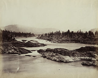
Kettle Falls was an ancient and important salmon fishing site on the upper reaches of the Columbia River, in what is today the U.S. state of Washington, near the Canada–US border. The falls consisted of a series of rapids and cascades where the river passed through quartzite rocks deposited by prehistoric floods on a substrate of Columbia River basalt. The river dropped nearly 50 feet (15 m), and the sound of the falls could be heard for miles away. Kettle Falls was inundated in 1940, as the waters of the reservoir Lake Roosevelt rose behind Grand Coulee Dam, permanently flooding the site.

<span class="mw-page-title-main">Washington State Route 20</span> East-west state highway in Washington, US

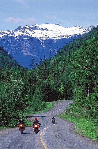
State Route 20 (SR 20), also known as the North Cascades Highway, is a state highway that traverses the U.S. state of Washington. It is the state's longest highway, traveling 436 miles (702 km) across the northern areas of Washington, from U.S. Route 101 (US 101) at Discovery Bay on the Olympic Peninsula to US 2 near the Idaho state border in Newport. The highway travels across Whidbey Island, North Cascades National Park, the Okanagan Highland, the Kettle River Range, and the Selkirk Mountains. SR 20 connects several major north–south state highways, including Interstate 5 (I-5) in Burlington, US 97 through the Okanogan–Omak area, SR 21 in Republic, and US 395 from Kettle Falls to Colville.

<span class="mw-page-title-main">Monashee Mountains</span> Mountain range in the country of Canada

The Monashee Mountains are a mountain range lying mostly in British Columbia, Canada, extending into the U.S. state of Washington. They stretch 530 km (329 mi) from north to south and 150 km (93 mi) from east to west. They are a sub-range of the Columbia Mountains. The highest summit is Mount Monashee, which reaches 3,274 m (10,741 ft). The name is from the Scottish Gaelic monadh and sìth, meaning "moor" and "peace".

<span class="mw-page-title-main">Colville National Forest</span> U.S. National Forest in northeastern Washington state

The Colville National Forest is a U.S. National Forest located in northeastern Washington state. It is bordered on the west by the Okanogan–Wenatchee National Forest and the Kaniksu National Forest to the east. The forest also borders Little Pend Oreille National Wildlife Refuge and the Lake Roosevelt National Recreation Area.

There are over 30 lakes named Mud Lake within the U.S. state of Washington.

<span class="mw-page-title-main">Okanagan Highland</span> Geographical region in North America

The Okanagan Highland is an elevated hilly plateau area in British Columbia, Canada, and the U.S. state of Washington. Rounded mountains with elevations up to 8,000 ft (2,400 m) above sea level and deep, narrow valleys are characteristic of the region.

<span class="mw-page-title-main">St. Paul's Mission</span> United States historic place

St. Paul's Mission was a Jesuit mission church established in the Hudson's Bay Company's (HBC) Columbia District, in the Pacific Northwest region of North America, in the 1830s. The mission was built near the HBC's Fort Colville, on the bluff then overlooking Kettle Falls on the Columbia River. The building still stands today.

Sherman Pass is a high mountain pass that crosses the Kettle River Range in the state of Washington. It is the highest pass in the state maintained all year. The pass is located on the Sherman Pass Scenic Byway which traverses the Colville National Forest. The pass is surrounded by the aftermath of the 1988 White Mountain Fire. The pass was named after American Civil War General William Tecumseh Sherman who traveled across the pass in 1883.

The Colville River is a 60-mile (100 km) long tributary of the Columbia River in northeastern Washington in the United States. The Colville River begins in southern Stevens County, Washington at the confluence of Sheep Creek and Deer Creek. It flows northwest past Colville and into the Columbia River near Kettle Falls.

<span class="mw-page-title-main">Sanpoil River</span> River in Okanagan Highlands, United States

The Sanpoil River is a tributary of the Columbia River, in the U.S. state of Washington. The river is named for the Sanpoil, the Interior Salish people who live along the river course. The name is from the Okanagan term [snpʕʷílx], meaning "people of the gray country", or "gray as far as one can see".

The Colville people, are a Native American people of the Pacific Northwest. The name Colville comes from association with Fort Colville, named after Andrew Colvile of the Hudson's Bay Company. Earlier, outsiders often called them Scheulpi, Chualpay, or Swhy-ayl-puh; the French traders called them Les Chaudières in reference to Kettle Falls. The neighboring Coeur d'Alene called them Sqhwiyi̱'ɫpmsh and the Spokane knew them as Sxʷyelpetkʷ. Their name in nselxcin, sx̌ʷýʔłpx, refers to "sharp pointed trees".

<span class="mw-page-title-main">Chief Tonasket Log Cabin</span> Log cabin in Okanogan County, Washington

Chief Tonasket Log Cabin is a log cabin in Okanogan County, Washington, once the home of Chief Tonasket, born 1822. It is along Washington State Route 21 near Curlew, Washington. Tonasket moved to the Colville Indian Reservation, now the Old North Half in the Curlew area, after signing the 1883 treaty with the United States. Tonasket died in 1891, and the structure was operated as the "Curlew Store" for a period of time by G.S. Helphry and J. Walters, beginning in 1896, supplying prospectors coming to the Okanogan gold rush.

The Spokane Falls & Northern (SF&N) is a historic railroad that operated in northeast Washington state. The SF&N initially connected the city of Spokane with the Canada–United States border at Waneta, British Columbia.

References

  1. U.S. Geological Survey Geographic Names Information System: Kettle River Range
  2. USDA Forest Service, Colville National Forest
  3. Nez Perce Tribe and Confederated Tribes of the Colville Reservation, map
  4. Peakbagger.com, Peaks List, Copper Butte, Washington
  5. Kettle River Range in the Canadian Mountain Encyclopedia
  6. "America's Byways, Sherman Pass Scenic Byway". Archived from the original on 2007-03-20. Retrieved 2012-03-04.
  7. Heafield, Reginald. "The Official History of the Washington National Guard". Washington National Guard. Retrieved 24 April 2015.
  8. 1 2 3 4 5 6 WashingtonGold.net. "Ferry County Washington Gold" . Retrieved 11 April 2014.
  9. USDA Forest Service, Kettle Crest (North) National Recreation Trail
  10. Washington Tourism Alliance, White Mountain Fire Interpretive Site, official state site
  11. "Nine wildfires since Aug. 14". Ellensburg Daily Record. Ellensburg, WA. Aug 25, 2001.
  12. Associated Press. "Fire crews keep their eyes on the winds in 4 states: Washington Burns". The Herald. Everett, WA. p. A10.
  13. "Kettle Complex". InciWeb the Incident Information System. Archived from the original on 2015-08-20.