Twentynine Palms is a city in San Bernardino County, California. It serves as one of the entry points to Joshua Tree National Park.

Spring Mountain Ranch State Park is a public recreation area located within the Red Rock Canyon National Conservation Area in Nevada's Cottonwood Valley, five miles (8.0 km) northwest of Blue Diamond, Nevada. The state park preserves the historic Sandstone Ranch, which was entered into the National Register of Historic Places as a historic district in 1976.

The Ford River Rouge complex is a Ford Motor Company automobile factory complex located in Dearborn, Michigan, along the River Rouge, upstream from its confluence with the Detroit River at Zug Island. Construction began in 1917, and when it was completed in 1928, it was the largest integrated factory in the world, surpassing Buick City, built in 1904.

The Morongo Basin is an endorheic basin and valley region located in eastern San Bernardino County, in Southern California.
Loleta is a ghost town in Elk County, Pennsylvania, United States. The town was founded in 1889, and at its peak contained 600 inhabitants, a saw mill, a shingle mill, and a broom factory. A railway connected the town with Sheffield, where the products of the factories were sold. After the timber supply was exhausted in 1913, the mills shut down and the town was deserted. The site is now a recreational area within Allegheny National Forest. Its altitude is 1,348 feet (411 m).

The following are all the contributing resources to the Saint Anthony Falls Historic District in Minneapolis, Minnesota, United States. The District is listed on the National Register of Historic Places, thus these properties are on the NRHP. The "period of significance" of the District was 1858–1941. The district's archaeological record is considered to be one of the most-endangered historic sites in Minnesota.

The Bridgeport Covered Bridge is located in Bridgeport, Nevada County, California, southwest of French Corral and north of Lake Wildwood. It is used as a pedestrian crossing over the South Yuba River. The bridge was built in 1862 by David John Wood. Its lumber came from Plum Valley in Sierra County, California. The bridge was closed to vehicular traffic in 1972 and pedestrian traffic in 2011 due to deferred maintenance and "structural problems".

The Hubert H. Bancroft Ranch House is a historic house museum at 9050 Memory Lane in Spring Valley, California. Built in 1856, it is the oldest Anglo-American building in the town. From 1885 until his death in 1918, it was home to Hubert Howe Bancroft, a pioneering historian of the western United States, Mexico, and Central America. Now managed by the local historical society as a museum, it was designated a National Historic Landmark in 1962 for its association with Bancroft, and was registered as a California Historical Landmark in 1958.

Joshua Tree National Park is an American national park in southeastern California, east of San Bernardino and Los Angeles and north of Palm Springs. It is named after the Joshua trees native to the Mojave Desert. Originally declared a national monument in 1936, Joshua Tree was redesignated as a national park in 1994 when the U.S. Congress passed the California Desert Protection Act. Encompassing a total of 795,156 acres – slightly larger than the state of Rhode Island – the park includes 429,690 acres of designated wilderness. Straddling San Bernardino and Riverside Counties, the park includes parts of two deserts, each an ecosystem whose characteristics are determined primarily by elevation: the higher Mojave Desert and the lower Colorado Desert. The Little San Bernardino Mountains traverse the southwest edge of the park.

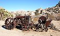
The Desert Queen Mine in the Colorado Desert was one of the more long-lived gold mines of Southern California's high desert region. The abandoned mine is located in Riverside County, California within the boundaries of the Joshua Tree National Park and is included on the National Register of Historic Places. A hiking trail leads to the mine.
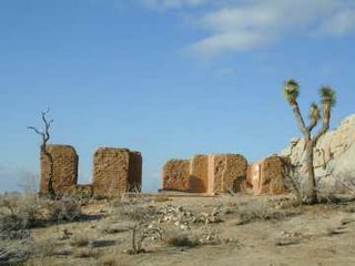
The Ryan House and Lost Horse Well are historic ruins in Joshua Tree National Park, California, United States. It was established by the family of J.D. Ryan, the later developers of the Lost Horse Mine, which became the most profitable mine in the area. The Lost Horse Well at the Ryan Ranch supplied water to the Lost Horse Mine, 3 miles (5 km) south and 750 feet (230 m), by pipeline. The popular park destination Ryan Mountain is named after him.

Cow Camp, located in Joshua Tree National Park, was associated with cattle rustling in the 1880s and 1890s. It was then later used as a line camp for cattle ranching. A stone chimney, two small dams, watering troughs and a well remain. One dam was built by local rancher and character William F. Keys.
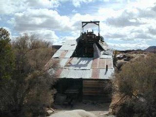
The Wall Street Mill in Joshua Tree National Park was a complete and operable gold ore crushing mill featuring late-19th century two-stamp mill machinery. Consequently, the significance encompasses the mill machinery, the building which houses it, the well which supplied water for the mill's operation, and the well pump. It is the only gold ore crushing mill in the region that retains integrity.
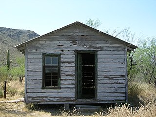
The Bates Well Ranch, also known as the Bates Well, Growler Well, Gray Ranch and El Veit, was one of the fifteen ranches and line camps in the Gray family cattle business in the Sonoran Desert country north of the US-Mexico border in Pima County, Arizona. Operating for nearly 60 years, the ranch is now part of Organ Pipe Cactus National Monument.

Mill City Museum is located in the ruins of the Washburn "A" Mill next to Mill Ruins Park on the banks of the Mississippi River in Minneapolis. The museum, an entity of the Minnesota Historical Society that opened in 2003, focuses on the founding and growth of Minneapolis, especially flour milling and the other industries that used hydropower from Saint Anthony Falls. The mill complex that the museum is within, dates from the 1870s and is listed on the National Register of Historic Places. It is also part of the St. Anthony Falls Historic District and within the Mississippi National River and Recreation Area.
The Twenty-Nine Palms Band of Mission Indians of California is a federally recognized tribe of Mission Indians with a reservation consisting of two sections, one located near the cities of Indio and Coachella in Riverside County, and the other in the city of Twentynine Palms in San Bernardino County, California. While many scholars regard the tribe as being Luiseño, the tribe itself identifies as being Chemehuevi.
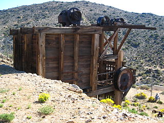
Lost Horse Mine is a historic gold and silver mine in the Lost Horse Valley of Joshua Tree National Park. Between 1894 and 1931, it produced 10,000 ounces of gold and 16,000 ounces of silver. It was first developed by Johnny Lang, then by J.D. Ryan. Scarce resources for steam powered pumps and mining equipment, led to denuding the local mountains of trees, which is still clearly visible in 2014.
Elizabeth Campbell (1893–1971) was an American archeologist, notable for proposing a much earlier date for the presence of man in the desert Southwest than was generally accepted. She worked with her husband William (Bill) Campbell and first proposed that artifacts found along the shores of Lake Mojave and other Pleistocene lakes and rivers of the desert West were contemporaneous with the presence of water. They showed that there were virtually no sites that were not associated with archaic water sources. They hypothesized that the geologic features associated with the artifacts could be used to date the period of human habitation. This is the first use of what has become known as environmental archaeology.